File:1932_Chinese_Map_of_Tientsin_(Tianjin_or_Tienjin),_China_-_Geographicus_-_Tienjin-showa7-1932.jpg
維基百科,自由的 encyclopedia
預覽大小:403 × 599 像素。 其他解析度:161 × 240 像素 | 323 × 480 像素 | 516 × 768 像素 | 689 × 1,024 像素 | 1,377 × 2,048 像素 | 3,000 × 4,460 像素。
原始檔案 (3,000 × 4,460 像素,檔案大小:3.22 MB,MIME 類型:image/jpeg)
| Tientsin. | |||||||
|---|---|---|---|---|---|---|---|
| 作家 | |||||||
| 標題 |
Tientsin. |
||||||
| 描述 |
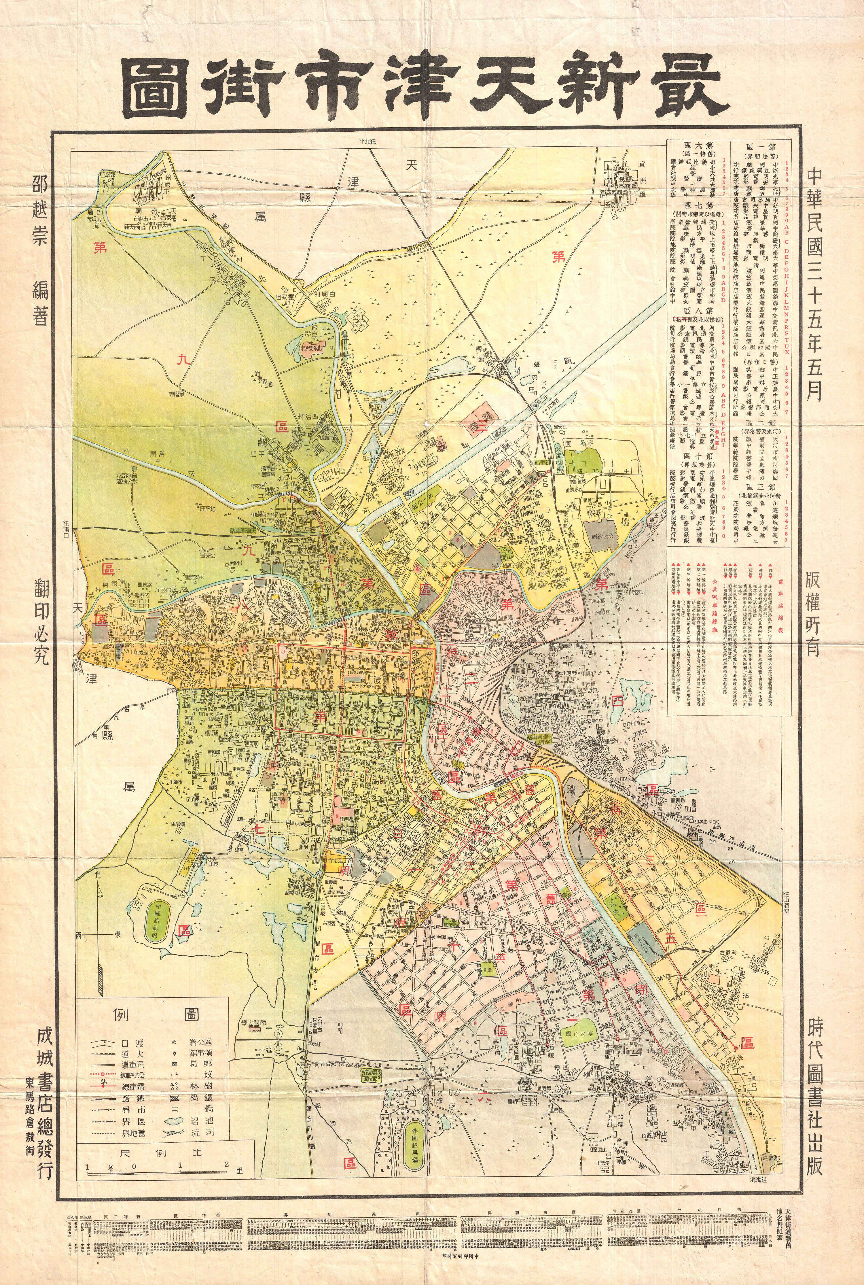
English: A highly uncommon map of Tianjin (Chinese: ??; pinyin: Tianjin; Wade-Giles: T'ien-chin; [t?i??n?? t??in??]; Postal map spelling: Tientsin), China dating to 1932. Tientsin was a major trading center in Northern China and, like Shanghai, had administrative concessions to several foreign nations including England, Italy, France, Austria-Hungary, Belgium, Japan, Germany and Russia. Curiously none of the foreign concessions are noted on this map, suggesting it was issued by an isolationist anti-trade element. It does however identify streets, rail lines, administrative buildings, parks, and public centers. All text in Chinese. |
||||||
| 日期 | 1932年 (dated) | ||||||
| 尺寸 |
高度:29英寸(73.6釐米);寬度:20英寸(50.8釐米) dimensions QS:P2048,29U218593 dimensions QS:P2049,20U218593 |
||||||
| 登錄號 |
Geographicus link: Tienjin-showa7-1932 |
||||||
| 來源/攝影者 |
|
||||||
| 授權許可 (重用此檔案) |
|
||||||
說明
添加單行說明來描述出檔案所代表的內容
在此檔案描寫的項目
描繪內容
多媒體型式 繁體中文 (已轉換拼寫)
image/jpeg
3,376,777 位元組
4,460 像素
3,000 像素
檔案歷史
點選日期/時間以檢視該時間的檔案版本。
| 日期/時間 | 縮圖 | 尺寸 | 用戶 | 備註 | |
|---|---|---|---|---|---|
| 目前 | 2011年3月24日 (四) 12:30 | | 3,000 × 4,460(3.22 MB) | BotMultichillT | {{subst:User:Multichill/Geographicus |link=http://www.geographicus.com/P/AntiqueMap/Tienjin-showa7-1932 |product_name=1932 Chinese Map of Tientsin (Tianjin or Tienjin), China |map_title=Tientsin. |description=A highly uncommon map of Tianjin (Chinese: ??; |
,_China_-_Geographicus_-_Tienjin-showa7-1932.jpg)