File:Dissolution_of_Austria-Hungary.png
維基百科,自由的 encyclopedia
預覽大小:800 × 473 像素。 其他解析度:320 × 189 像素 | 640 × 378 像素 | 1,024 × 605 像素 | 1,641 × 970 像素。
原始檔案 (1,641 × 970 像素,檔案大小:182 KB,MIME 類型:image/png)

|
本圖片是以PNG、GIF或JPEG格式上傳。然而,其中包含的資料或訊息,應該重新建立成可縮放向量圖形(SVG)檔案,以更有效率或更準確的方式儲存。如有可能,請上傳本圖片的SVG格式版本。在上傳之後,請修改維基各姊妹計畫中所有使用舊版圖片的條目(列在圖像連結章節中),替換為新版圖片,並在舊圖片的描述頁中加入{{Vector version available|新圖片名稱.svg}}模板,同時移除本模板。
|
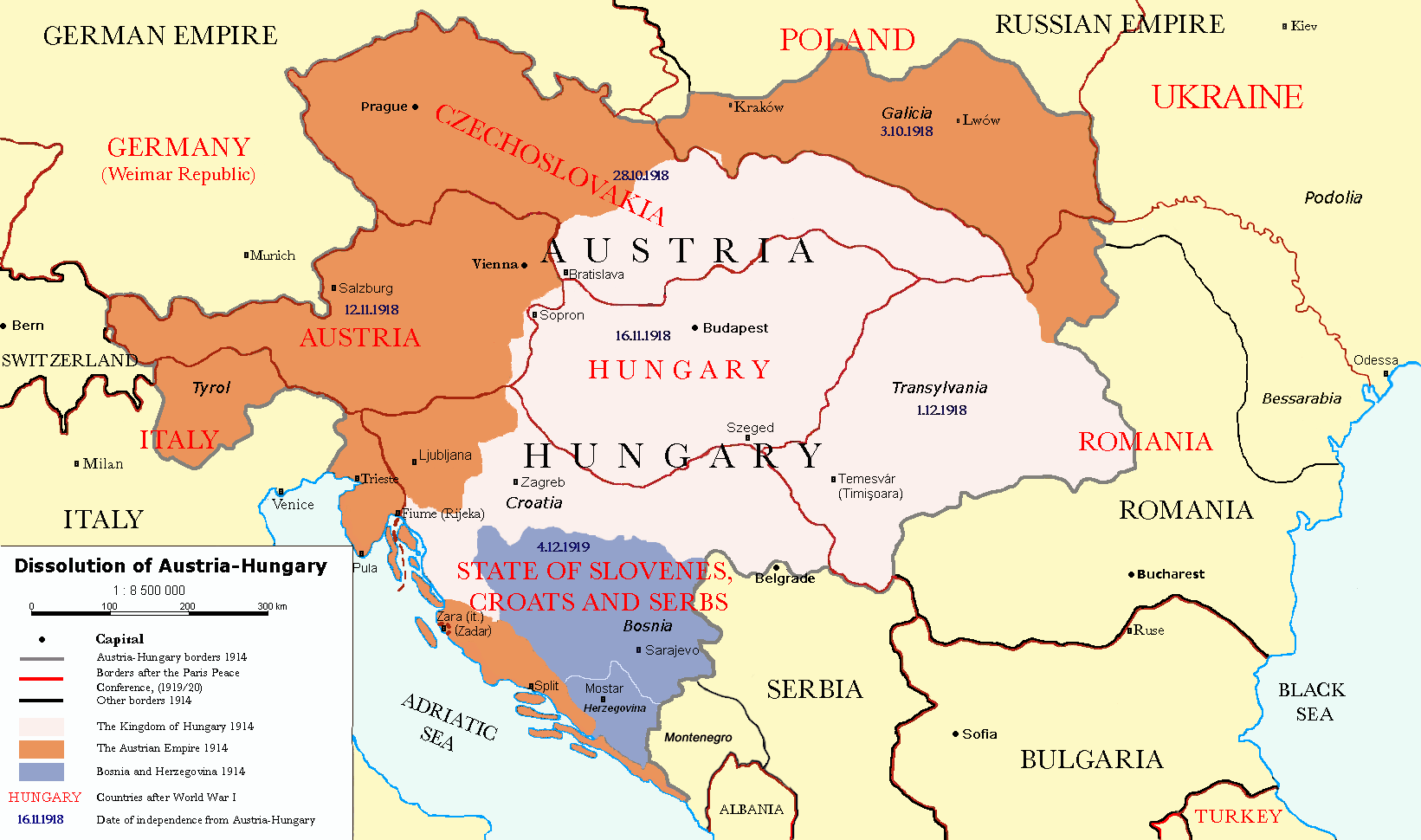
| 描述Dissolution of Austria-Hungary.png |
Čeština: Rozdělení Rakouska-Uherska po první světové válce, podle Pařížských předměstských smluv (Versailles s Německem, Saint-Germain-en-Laye s Rakouskem, Neuilly-sur-Seine s Bulharskem, Trianon s Maďarskem, Sèvres s Tureckem), dojednaných na Pařížské mírové konferenci (1919). Deutsch: Das Ende Österreich-Ungarns nach den Pariser Vorortverträgen. English: The end of Austria-Hungary after the Paris Treaty. |
| 日期 | (UTC) |
| 來源 | |
| 作者 |
|
| 其他版本 | العربيَّة |
| 這是一張修飾過的圖片,即本圖片是用軟體修改過後的版本,修改的方式或內容有:translated to english。原版圖片來源:Österreich-Ungarns Ende.png。修改者:P. S. Burton。
|
我,本作品的著作權持有者,決定用以下授權條款發佈本作品:
| 此檔案採用共享創意 姓名標示-相同方式分享 3.0 未在地化版本授權條款。 | ||
| ||
| 已新增授權條款標題至此檔案,作為GFDL授權更新的一部份。http://creativecommons.org/licenses/by-sa/3.0/CC BY-SA 3.0Creative Commons Attribution-Share Alike 3.0truetrue |

|
已授權您依據自由軟體基金會發行的無固定段落、封面文字和封底文字GNU自由文件授權條款1.2版或任意後續版本,對本檔進行複製、傳播和/或修改。該協議的副本列在GNU自由文件授權條款中。http://www.gnu.org/copyleft/fdl.htmlGFDLGNU Free Documentation Licensetruetrue |
您可以選擇您需要的授權條款。
原始上傳日誌
This image is a derivative work of the following images:
- File:Österreich-Ungarns_Ende.png licensed with Cc-by-sa-3.0-migrated, GFDL
- 2007-07-16T11:59:46Z Nihad Hamzic 1568x970 (81916 Bytes) The original image seems to had been saved as JPEG, and that some previous uploader had simply directly converted it to PNG. I have greatly optimised its size by removing JPEG artifacts, reducing color domain, etc.
- 2006-01-23T20:47:06Z AlphaCentauri 1568x970 (924912 Bytes) kleine Änderungen
- 2005-09-23T14:27:32Z AlphaCentauri 1568x970 (924912 Bytes) Laibach and Triest
- 2005-09-17T03:29:55Z Berkut 1568x970 (355556 Bytes) better file compression
- 2005-09-16T09:39:55Z Kallgan 1568x970 (438065 Bytes) Das Ende Österreich-Ungarns nach dem Pariser Vorortverträgen. Selbsterstellte Karte. {{Bild-GFDL}} (Borders between Romania and Bulgaria in Dobrogea modified)(Source: Goode's World Atlas, Rand McNally & Company, 1932 & 19
- 2005-07-04T13:39:25Z AlphaCentauri 1568x970 (924912 Bytes) verbessert
- 2005-04-28T19:29:14Z AlphaCentauri 1568x970 (924912 Bytes) so, nochmals verbessert
- 2005-04-12T18:45:25Z AlphaCentauri 1568x970 (924912 Bytes) nochmals verbessert
- 2005-04-12T15:06:42Z AlphaCentauri 1568x970 (924912 Bytes)
- 2005-04-12T14:47:08Z AlphaCentauri 1568x970 (924912 Bytes) verbesserte Version
- 2005-01-05T20:59:50Z AlphaCentauri 1568x970 (924912 Bytes) verbesserte Version
- 2004-12-29T10:14:48Z AlphaCentauri 1568x970 (924912 Bytes) Das Ende Österreich-Ungarns (Karte)
Uploaded with derivativeFX
說明
添加單行說明來描述出檔案所代表的內容
GNU自由文檔許可證1.2或更高版本 繁體中文 (已轉換拼寫)
23 11 2010
1914
多媒體型式 繁體中文 (已轉換拼寫)
image/png
檔案歷史
點選日期/時間以檢視該時間的檔案版本。
| 日期/時間 | 縮圖 | 尺寸 | 用戶 | 備註 | |
|---|---|---|---|---|---|
| 目前 | 2021年12月26日 (日) 17:57 | | 1,641 × 970(182 KB) | Claude Zygiel | Cosmetic and correct romanian-ukrainian border since April 9, 1918 |
| 2020年12月6日 (日) 16:27 |  | 1,568 × 970(175 KB) | Crash48 | before 1919, the Greek-Bulgarian border was far to the southwest | |
| 2020年12月3日 (四) 18:08 |  | 1,568 × 970(175 KB) | Crash48 | Lwów didn't become Lviv until 1939 | |
| 2020年12月2日 (三) 16:37 |  | 1,568 × 970(148 KB) | Crash48 | Romanian-Ukrainian border was way off; fixed according to File:Romania1901.JPG | |
| 2020年3月10日 (二) 15:20 |  | 1,568 × 970(229 KB) | Kufl | Odessa was never part of the Romania at that time | |
| 2013年10月10日 (四) 15:58 |  | 1,568 × 970(163 KB) | Lvivske | Incorrectly states that Ukraine was the Russian SFSR (Russia is not seen on the map), the area of Ukraine was the Ukraine post-WW1 and later following another war, the Ukrainian Soviet Socialist Republic, and joined ... | |
| 2010年11月24日 (三) 21:36 |  | 1,568 × 970(164 KB) | P. S. Burton | Ungarn ->Hungary etc. | |
| 2010年11月23日 (二) 21:46 |  | 1,568 × 970(163 KB) | P. S. Burton | Zara -> Zara (Zadar) | |
| 2010年11月23日 (二) 21:41 |  | 1,568 × 970(163 KB) | P. S. Burton | Black Sea ->BLACK SEA | |
| 2010年11月23日 (二) 21:39 |  | 1,568 × 970(163 KB) | P. S. Burton | {{Information |Description={{cs|Rozdělení Rakouska-Uherska po první světové válce, podle Pařížských předměstských smluv ([[:cs:Versailles|Ver |
檔案用途
下列3個頁面有用到此檔案:
全域檔案使用狀況
以下其他 wiki 使用了這個檔案:
- ar.wikipedia.org 的使用狀況
- azb.wikipedia.org 的使用狀況
- ba.wikipedia.org 的使用狀況
- ca.wikipedia.org 的使用狀況
- de.wikipedia.org 的使用狀況
- el.wikipedia.org 的使用狀況
- en.wikipedia.org 的使用狀況
- Austria-Hungary
- Nation state
- Dalmatia
- Aftermath of World War I
- Treaty of Saint-Germain-en-Laye (1919)
- World War I
- Anschluss
- Key events of the 20th century
- Wikipedia:Graphics Lab/Map workshop/Archive/Dec 2010
- Green Cadres
- Dissolution of Austria-Hungary
- Austria victim theory
- User:Lord Milner/Lord Milner Timeline
- User:Lord Milner/sandbox/Lord Milner's Life Timeline
- Draft:Timeline of Alfred Milner
- User:Falcaorib/Austria-Hungary
- fr.wikipedia.org 的使用狀況
- he.wikipedia.org 的使用狀況
- hr.wikipedia.org 的使用狀況
- hy.wikipedia.org 的使用狀況
- id.wikipedia.org 的使用狀況
- io.wikipedia.org 的使用狀況
- it.wikipedia.org 的使用狀況
- lmo.wikipedia.org 的使用狀況
- lt.wikipedia.org 的使用狀況
- no.wikipedia.org 的使用狀況
- pnb.wikipedia.org 的使用狀況
- pt.wikipedia.org 的使用狀況
- ro.wikipedia.org 的使用狀況
- sh.wikipedia.org 的使用狀況
- sv.wikipedia.org 的使用狀況
- ta.wikipedia.org 的使用狀況
檢視此檔案的更多全域使用狀況。
詮釋資料
此檔案中包含擴展的資訊。這些資訊可能是由數位相機或掃描器在建立時或數位化過程中所加入。
如果此檔案的來源檔案已被修改,一些資訊在修改後的檔案中將不能完全反映出來。
| 水平解析度 | 37.8 dpc |
|---|---|
| 垂直解析度 | 37.8 dpc |