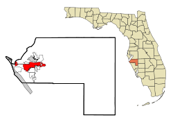
布雷登頓(英語:Bradenton)位於美國佛羅里達州中部,是馬納蒂縣的縣治所在,建立於1842年。根據美國普查局於2019年估計,該地人口為59,439人[6]。
| 布雷登頓 | |
|---|---|
| Bradenton | |
 | |
 | |
| 坐標:27°29′N 82°35′W | |
| 國家 | |
| 州 | 佛羅里達州 |
| 縣 | 馬納提縣 |
| 定居 | 1842[1] |
| 建制 | 1903 |
| 曾用名 |
|
| 政府 | |
| • 類型 | 市長-議會制 |
| • 市長 | Gene Brown[2] |
| • 城市管理員 | Rob Perry |
| 面積[3] | |
| • 城市 | 17.50 平方英里(45.32 平方公里) |
| • 陸地 | 14.34 平方英里(37.13 平方公里) |
| • 水域 | 3.16 平方英里(8.19 平方公里) 16.14% |
| 海拔 | 6 英尺(1.83 公尺) |
| 人口(2020) | |
| • 城市 | 55,698人 |
| • 密度 | 3,884.64人/平方英里(1,499.90人/平方公里) |
| • 市區 | 779,075 (US: 57th) |
| • 市區密度 | 1,927.1人/平方英里(744.0人/平方公里) |
| • 都會區 | 859,760 (US: 70th) |
| 時區 | EST(UTC-5:00) |
| • 夏時制 | EDT(UTC-4:00) |
| ZIP Codes | 34201–34212, 34280–34282 |
| 電話區號 | 941 |
| FIPS code | 12-07950[4] |
| GNIS feature ID | 0279311[5] |
| 網站 | cityofbradenton |
氣候
| 佛羅里達州布雷登頓 1991-2020 normals | |||||||||||||
|---|---|---|---|---|---|---|---|---|---|---|---|---|---|
| 月份 | 1月 | 2月 | 3月 | 4月 | 5月 | 6月 | 7月 | 8月 | 9月 | 10月 | 11月 | 12月 | 全年 |
| 平均高溫 °F(°C) | 72.0 (22.2) |
75.0 (23.9) |
78.4 (25.8) |
83.0 (28.3) |
88.2 (31.2) |
91.1 (32.8) |
92.0 (33.3) |
91.8 (33.2) |
90.0 (32.2) |
85.2 (29.6) |
78.6 (25.9) |
74.0 (23.3) |
83.3 (28.5) |
| 日均氣溫 °F(°C) | 62.1 (16.7) |
64.9 (18.3) |
68.4 (20.2) |
73.0 (22.8) |
78.4 (25.8) |
82.4 (28.0) |
83.6 (28.7) |
83.7 (28.7) |
82.1 (27.8) |
76.7 (24.8) |
69.3 (20.7) |
64.5 (18.1) |
74.1 (23.4) |
| 平均低溫 °F(°C) | 52.2 (11.2) |
54.8 (12.7) |
58.4 (14.7) |
63.0 (17.2) |
68.5 (20.3) |
73.7 (23.2) |
75.2 (24.0) |
75.5 (24.2) |
74.2 (23.4) |
68.3 (20.2) |
60.1 (15.6) |
55.0 (12.8) |
64.9 (18.3) |
| 平均降水量 英寸(mm) | 2.76 (70) |
1.99 (51) |
3.11 (79) |
2.53 (64) |
3.49 (89) |
9.03 (229) |
8.91 (226) |
10.07 (256) |
7.43 (189) |
2.88 (73) |
1.82 (46) |
2.26 (57) |
56.28 (1,430) |
| 平均降水天數(≥ 0.01 in) | 7.5 | 5.7 | 5.7 | 5.6 | 6.9 | 14.0 | 17.2 | 18.1 | 14.1 | 7.5 | 5.1 | 6.2 | 113.6 |
| 數據來源:NOAA[7][8] | |||||||||||||
參考
Wikiwand in your browser!
Seamless Wikipedia browsing. On steroids.
Every time you click a link to Wikipedia, Wiktionary or Wikiquote in your browser's search results, it will show the modern Wikiwand interface.
Wikiwand extension is a five stars, simple, with minimum permission required to keep your browsing private, safe and transparent.

