File:St_Moritz_Muottas.jpg
維基百科,自由的 encyclopedia
原始檔案 (1,920 × 1,280 像素,檔案大小:871 KB,MIME 類型:image/jpeg)
摘要
| 描述St Moritz Muottas.jpg |
Беларуская (тарашкевіца): Від на Сьв. Морыц і возера з Муотас да Шлярыгна, Грысонз. Швайцарыя.
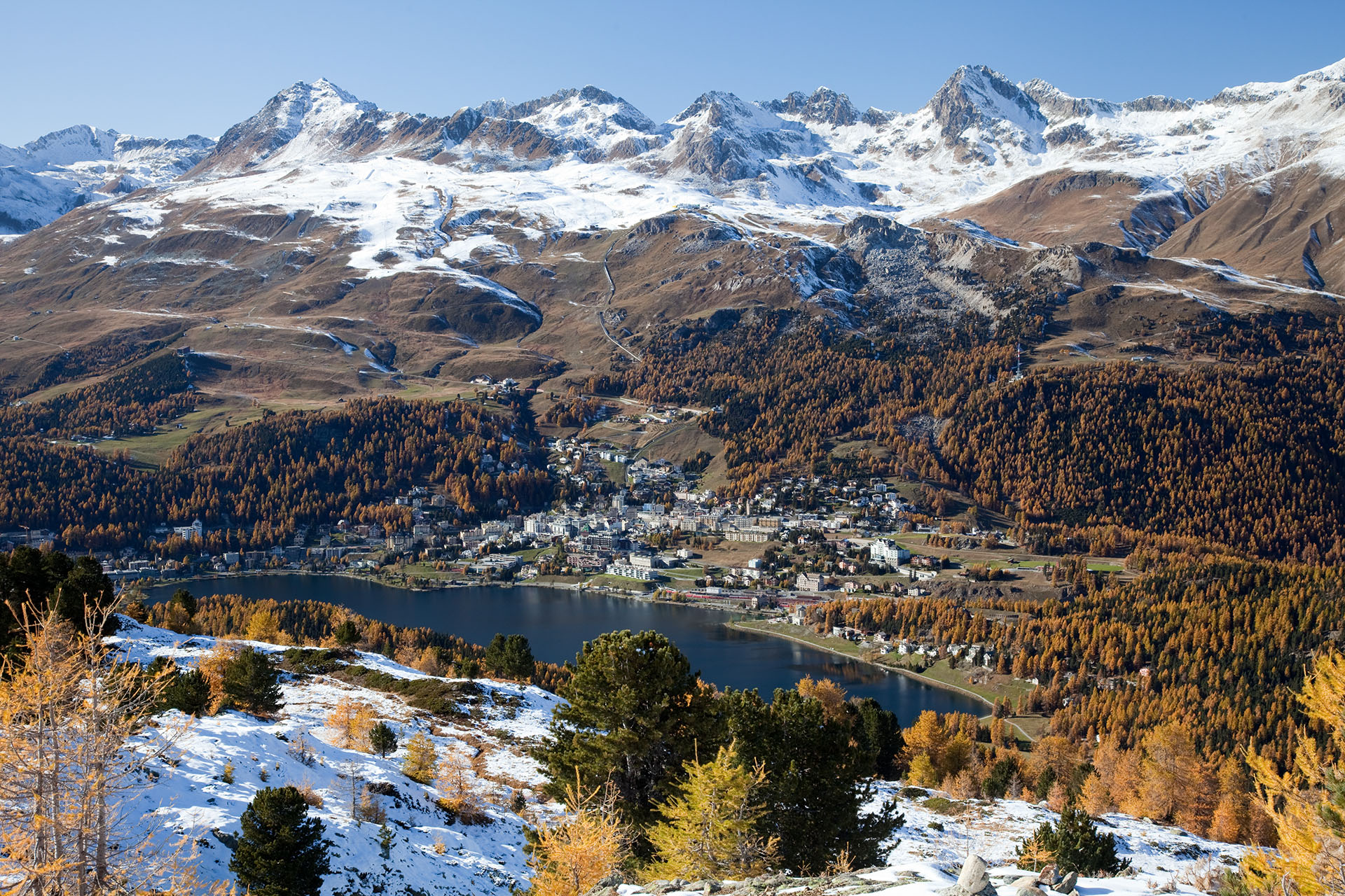
Deutsch: Blick auf St. Moritz, St. Moritzersee und Skigebiet Corviglia im Herbst von Muottas da Schlarigna – links Piz Nair (3056 m), Piz Grisch (3098 m) und Piz Corviglia (3060 m) in der Bildmitte, rechts der Piz Saluver (3159 m) und die Ausläufer des Piz Ot (3246 m) am Bildrand
English: View of St. Moritz and its lake, as seen from Muottas da Schlarigna, Grisons. Switzerland. On the left is Piz Nair (3056 m), to the right is Piz Saluver (3159 m)
Español: Vista de San Moritz y su lago. Tomado desde Muottas de Schlarigna, Grisones, Suiza.
Français : Vue sur Saint-Moritz et son lac, prise depuis Muottas da Schlarigna. Canton des Grisons (Suisse).
Rumantsch: Vista da Muottas da Schlarigna sin San Murezzan, il Lai da San Murezzan ed il territori da skis Corviglia. |
| 日期 | 2010年10月21日 (根據EXIF的資料) |
| 來源 | 自己的作品 |
| 作者 | Murdockcrc |
| 拍攝地點 | 46° 28′ 58.8″ 北, 9° 52′ 45.6″ 東 | 位於此地的本圖片與其他圖片: OpenStreetMap |
|---|
|

This image was selected as picture of the day on Wikimedia Commons for 2 April 2011. It was captioned as follows: English: View of St. Moritz and the lake, as seen from Muottas da Schlarigna, Grisons. Switzerland. Other languages:
Deutsch: Aufnahme von St. Moritz mit St. Moritzersee, vom Muottas Muragl aus gesehen (Kanton Graubünden in der Schweiz) English: View of St. Moritz and the lake, as seen from Muottas da Schlarigna, Grisons. Switzerland. Español: Vista de Sankt Moritz y el lago desde Muottas da Schlarigna (Cantón de los Grisones, Suiza). Français : Saint-Moritz et son lac, vus de Muottas da Schlarigna, Grisons. Suisse. Nederlands: Panorama van St. Moritz en het Meer van Sankt Moritz, gezien vanaf Muottas da Schlarigna, Graubünden, Zwitserland. 中文: 瑞士圣莫里茨风景 |
|
العربية ∙ جازايرية ∙ беларуская ∙ беларуская (тарашкевіца) ∙ български ∙ বাংলা ∙ català ∙ čeština ∙ Cymraeg ∙ Deutsch ∙ Schweizer Hochdeutsch ∙ Zazaki ∙ Ελληνικά ∙ English ∙ Esperanto ∙ español ∙ eesti ∙ euskara ∙ فارسی ∙ suomi ∙ français ∙ galego ∙ עברית ∙ हिन्दी ∙ hrvatski ∙ magyar ∙ հայերեն ∙ Bahasa Indonesia ∙ italiano ∙ 日本語 ∙ Jawa ∙ ქართული ∙ 한국어 ∙ kurdî ∙ Lëtzebuergesch ∙ lietuvių ∙ македонски ∙ മലയാളം ∙ मराठी ∙ Bahasa Melayu ∙ Nederlands ∙ Norfuk / Pitkern ∙ polski ∙ português ∙ português do Brasil ∙ rumantsch ∙ română ∙ русский ∙ sicilianu ∙ slovenčina ∙ slovenščina ∙ shqip ∙ српски / srpski ∙ svenska ∙ தமிழ் ∙ తెలుగు ∙ ไทย ∙ Tagalog ∙ Türkçe ∙ toki pona ∙ українська ∙ vèneto ∙ Tiếng Việt ∙ 中文 ∙ 中文(简体) ∙ 中文(繁體) ∙ +/− |
授權條款

|
已授權您依據自由軟體基金會發行的無固定段落、封面文字和封底文字GNU自由文件授權條款1.2版或任意後續版本,對本檔進行複製、傳播和/或修改。該協議的副本列在GNU自由文件授權條款中。http://www.gnu.org/copyleft/fdl.htmlGFDLGNU Free Documentation Licensetruetrue |
- 您可以自由:
- 分享 – 複製、發佈和傳播本作品
- 重新修改 – 創作演繹作品
- 惟需遵照下列條件:
- 姓名標示 – 您必須指名出正確的製作者,和提供授權條款的連結,以及表示是否有對內容上做出變更。您可以用任何合理的方式來行動,但不得以任何方式表明授權條款是對您許可或是由您所使用。
| 註解 InfoField | 該圖片含有註解:在維基媒體共享資源上查看註解 |
Piz Nair (3056 m)
Lake of St. Moritz (1768 m)
St. Moritz Train Station
Signalbahn (2130 m)
Piz Saluver (3161 m)
Sass da Muottas (2364 m)
Corviglia (2486 m)
Chantarella (2005 m)
Salastrains
Piz Grisch (3098 m)
Corn Suvretta (3072 m)
Piz Surgonda (3197 m)
Piz Bever (3230 m)
Munt da San Murezzan
Statzerwald
Piz Glüna (3102 m)
Piz Corviglia (3060 m)
Piz Grisch (3098 m)
Ils Chejels (2969 m)
Alp Giop
說明
在此檔案描寫的項目
描繪內容
沒有維基數據項目的某些值
維基共享資源特色圖片 中文 (已轉換拼寫)
維基共享資源品質形象 中文 (已轉換拼寫)
佳能 EOS 5D Mark II 中文 (已轉換拼寫)
21 10 2010
46°28'58.800"N, 9°52'45.599"E
0.03333333333333333333 秒
11
50 公釐
160
image/jpeg
檔案歷史
點選日期/時間以檢視該時間的檔案版本。
| 日期/時間 | 縮圖 | 尺寸 | 使用者 | 備註 | |
|---|---|---|---|---|---|
| 目前 | 2010年11月29日 (一) 10:09 | | 1,920 × 1,280(871 KB) | Murdockcrc | {{Information |Description={{en|1=View of St. Moritz and the lake, as seen from Muottas da Schlarigna, Grisons. Switzerland.}} {{es|1=Vista de San Moritz y su lago. Tomado desde Muottas de Schlarigna, Grisones, Suiza.}} |Source={{own}} |Author=[[User:Murd |
檔案用途
全域檔案使用狀況
以下其他 wiki 使用了這個檔案:
- ar.wikipedia.org 的使用狀況
- arz.wikipedia.org 的使用狀況
- be-tarask.wikipedia.org 的使用狀況
- bn.wikipedia.org 的使用狀況
- ceb.wikipedia.org 的使用狀況
- crh.wikipedia.org 的使用狀況
- cs.wikipedia.org 的使用狀況
- cv.wikipedia.org 的使用狀況
- da.wikipedia.org 的使用狀況
- de.wikipedia.org 的使用狀況
- en.wikipedia.org 的使用狀況
- St. Moritz
- Talk:St. Moritz
- Wikipedia:Featured pictures/Places/Landscapes
- Wikipedia:Featured pictures thumbs/26
- Wikipedia:Featured picture candidates/December-2010
- Wikipedia:Featured picture candidates/St. Moritz - Muottas da Schlarigna
- User talk:Murdockcrc
- List of Olympic venues in cross-country skiing
- Wikipedia:Picture of the day/July 2012
- Template:POTD/2012-07-28
- Wikipedia:Main Page history/2012 July 28
- Piz Saluver
- User:Mandip Si
- es.wikipedia.org 的使用狀況
- es.wikivoyage.org 的使用狀況
- fa.wikipedia.org 的使用狀況
- fi.wikipedia.org 的使用狀況
- fr.wikipedia.org 的使用狀況
- ha.wikipedia.org 的使用狀況
- he.wikipedia.org 的使用狀況
檢視此檔案的更多全域使用狀況。
詮釋資料
此檔案中包含其他資訊,這些資訊可能是由數位相機或掃描器在建立或數位化過程中所新增的。若檔案自原始狀態已被修改,一些詳細資料可能無法完整反映出已修改的檔案。
| 影像標題 | St. Moritz and the lake. On the background: Piz Nair (3056m), Piz Corviglia (3060m), Piz Saluver. |
|---|---|
| 相機製造商 | Canon |
| 相機型號 | Canon EOS 5D Mark II |
| 曝光時間 | 1/30 秒 (0.033333333333333) |
| 光圈值 | f/11 |
| ISO 速率 | 160 |
| 資料產生的日期時間 | 2010年10月21日 (四) 15:31 |
| 焦距 | 50毫米 |
| 像素合成 | RGB |
| 方位 | 標準 |
| 水平解析度 | 72 dpi |
| 垂直解析度 | 72 dpi |
| 使用軟體 | Adobe Photoshop CS4 Macintosh |
| 檔案修改日期時間 | 2010年11月29日 (一) 11:02 |
| 曝光模式 | 光圈優先 |
| Exif 版本 | 2.21 |
| 數位化的日期時間 | 2010年10月21日 (四) 15:31 |
| APEX 快門速度 | 4.9068908941756 |
| APEX 光圈 | 6.9188626907074 |
| APEX 曝光補償 | 0 |
| 最大陸地光圈 | 4 APEX(f/4) |
| 測光模式 | 模式 |
| 閃光燈 | 閃光燈未開啟、強制閃光燈關閉 |
| 時間數據亞秒數 | 81 |
| 文件建立時間數據亞秒數 | 81 |
| 文件數位化時間數據亞秒數 | 81 |
| 色彩空間 | sRGB |
| X 軸焦平面解析度 | 3,849.2115384615 |
| Y 軸焦平面解析度 | 3,908.1418439716 |
| 焦平面解析度單位 | 英寸 |
| 自訂影像處理 | 一般程序 |
| 曝光模式 | 自動曝光 |
| 白平衡 | 自動白平衡 |
| 場景拍攝類型 | 標準 |
| 對比度 | 39 |
| 飽和度 | 標準 |
| 銳利度 | 25 |
| 北緯或南緯 | 北緯 |
| 東經或西經 | 東經 |