File:Man-yi_2018_track.png
維基百科,自由的 encyclopedia
預覽大小:729 × 600 像素。 其他解析度:292 × 240 像素 | 584 × 480 像素 | 934 × 768 像素 | 1,245 × 1,024 像素 | 2,490 × 2,048 像素 | 2,700 × 2,221 像素。
原始檔案 (2,700 × 2,221 像素,檔案大小:1.77 MB,MIME 類型:image/png)
摘要
| 描述Man-yi 2018 track.png |
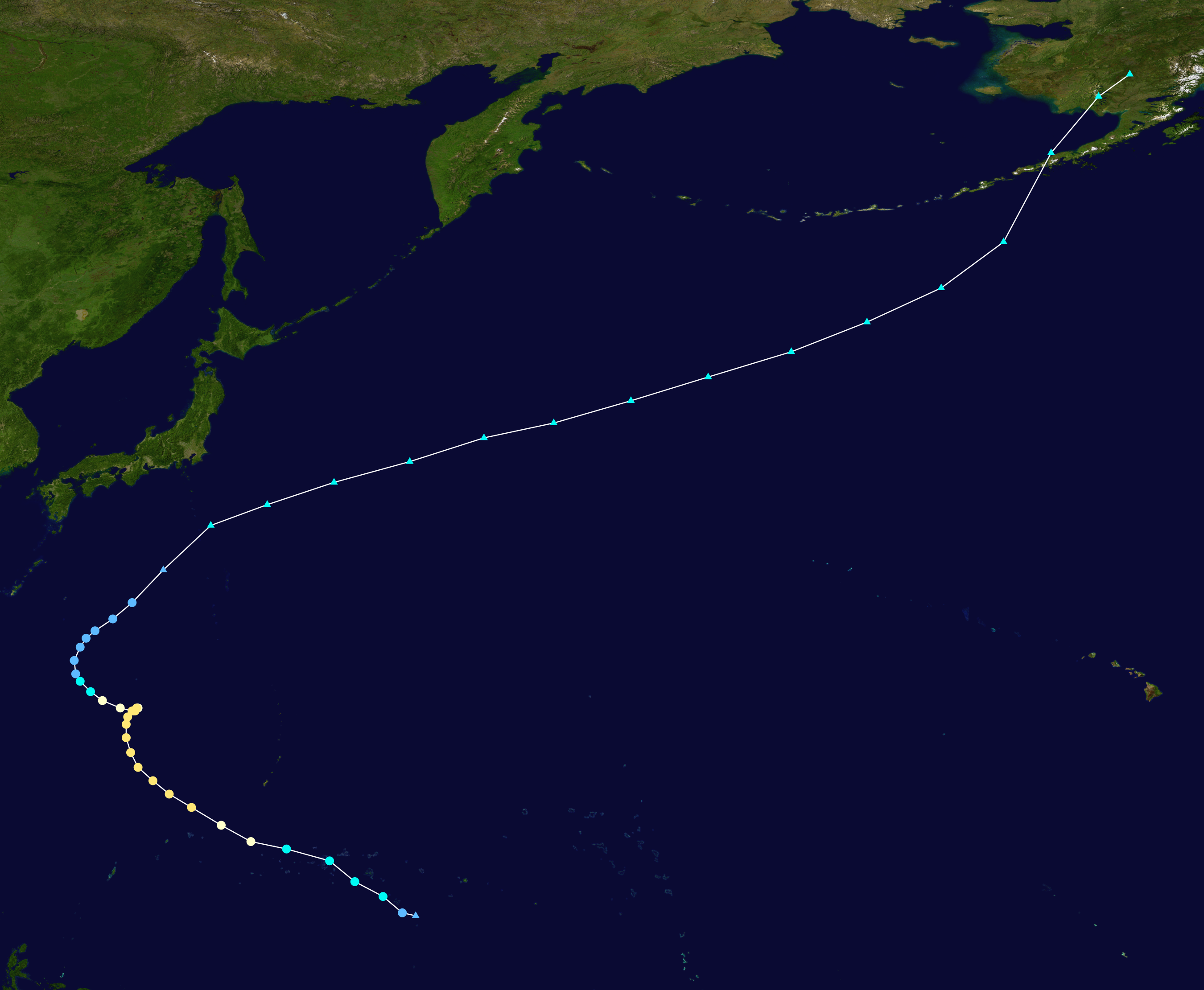
English: Track map of Typhoon Man-yi of the 2018 Pacific typhoon season. The points show the location of the storm at 6-hour intervals. The colour represents the storm's maximum sustained wind speeds as classified in the (see below), and the shape of the data points represent the nature of the storm, according to the legend below. Storm type |
||
| 日期 | 2018-11-20–2018-12-02 | ||
| 來源 | Created by Meow using Wikipedia:WikiProject Tropical cyclones/Tracks. The background image is from NASA. Tracking data is from the Joint Typhoon Warning Center[1]. | ||
| 作者 | Meow | ||
| Source code InfoField | Track map data table, if present below, is in HURDAT2 or ATCF format. See format details in [2] and [3], respectively.
|
授權條款
| Public domainPublic domainfalsefalse |
| 此作品已由其作者,Meow,釋出至公有領域。此授權條款在全世界均適用。 這可能在某些國家不合法,如果是的話: Meow授予任何人有權利使用此作品於任何用途,除受法律約束外,不受任何限制。 |
說明
添加單行說明來描述出檔案所代表的內容
在此檔案描寫的項目
描繪內容
image/png
1,853,369 位元組
2,221 像素
2,700 像素
檔案歷史
點選日期/時間以檢視該時間的檔案版本。
| 日期/時間 | 縮圖 | 尺寸 | 使用者 | 備註 | |
|---|---|---|---|---|---|
| 目前 | 2020年9月16日 (三) 18:43 | | 2,700 × 2,221(1.77 MB) | Supportstorm | Corrections |
| 2020年9月16日 (三) 18:42 |  | 2,700 × 2,221(1.77 MB) | Supportstorm | Reverted to version as of 01:24, 21 January 2020 (UTC) | |
| 2020年7月11日 (六) 06:45 |  | 2,700 × 2,221(1.76 MB) | Meow | JTWC revised the best track on 13 June 2020 | |
| 2020年1月21日 (二) 01:24 |  | 2,700 × 2,221(1.77 MB) | Supportstorm | JTWC/JMA/OPC data | |
| 2020年1月19日 (日) 03:37 |  | 2,700 × 2,220(1.77 MB) | Supportstorm | IBTrACS data + JMA/OPC map data past 180E | |
| 2019年10月6日 (日) 13:38 |  | 2,700 × 2,221(1.76 MB) | Meow | JTWC best track data | |
| 2019年1月12日 (六) 14:22 |  | 2,700 × 2,264(1.78 MB) | Meow | RSMC best track data since 11-27 00Z and OPC data from 11-30 18Z to 12-02 00Z | |
| 2018年11月28日 (三) 14:16 |  | 2,700 × 2,076(389 KB) | Meow | 11-28 06Z | |
| 2018年11月27日 (二) 14:39 |  | 2,700 × 1,812(338 KB) | Meow | 11-27 12Z | |
| 2018年11月21日 (三) 13:32 |  | 2,700 × 1,669(614 KB) | Meow | 11-21 12Z |
檔案用途
下列2個頁面有用到此檔案:
全域檔案使用狀況
以下其他 wiki 使用了這個檔案:
- de.wikipedia.org 的使用狀況
- en.wikipedia.org 的使用狀況
- ja.wikipedia.org 的使用狀況
- ko.wikipedia.org 的使用狀況
- pt.wikipedia.org 的使用狀況
- ru.wikipedia.org 的使用狀況
- th.wikipedia.org 的使用狀況
- tl.wikipedia.org 的使用狀況
- vi.wikipedia.org 的使用狀況
- www.wikidata.org 的使用狀況