File:Kelenken_holotype_site.png
維基百科,自由的 encyclopedia
無更高解析度可提供。
Kelenken_holotype_site.png (255 × 362 像素,檔案大小:47 KB,MIME 類型:image/png)
摘要
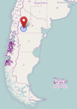
| 描述Kelenken holotype site.png |
English: Map showing the approximate location (near the village Comallo) where the holotype of Kelenken was found. Nederlands: Kaart waarop bij benadering de vindplaats (in de buurt van het dorpje Comallo) van het holotype van Kelenken te zien is. |
| 日期 | |
| 來源 | OpenStreetMap ([1]) |
| 作者 | OpenStreetMap users |
授權條款
| This work contains information from OpenStreetMap, which is made available under the Open Database License (ODbL).
The ODbL does not require any particular license for maps produced from ODbL data. Prior to 1 August 2020, map tiles produced by the OpenStreetMap Foundation were licensed under the CC-BY-SA-2.0 license. Maps produced by other people may be subject to other licences.Open Database LicenseODbLhttp://opendatacommons.org/licenses/odbl/1.0/true |
說明
添加單行說明來描述出檔案所代表的內容
在此檔案描寫的項目
描繪內容
27 5 2013
檔案歷史
點選日期/時間以檢視該時間的檔案版本。
| 日期/時間 | 縮圖 | 尺寸 | 使用者 | 備註 | |
|---|---|---|---|---|---|
| 目前 | 2022年2月11日 (五) 19:16 | | 255 × 362(47 KB) | FunkMonk | Cropped unnecessary top. |
| 2013年5月27日 (一) 18:16 |  | 255 × 534(49 KB) | Amphicoelias | User created page with UploadWizard |
檔案用途
下列頁面有用到此檔案:
全域檔案使用狀況
以下其他 wiki 使用了這個檔案:
- ar.wikipedia.org 的使用狀況
- cs.wikipedia.org 的使用狀況
- fr.wikipedia.org 的使用狀況
- he.wikipedia.org 的使用狀況
- hu.wikipedia.org 的使用狀況
- id.wikipedia.org 的使用狀況
- ja.wikipedia.org 的使用狀況
- nl.wikipedia.org 的使用狀況
- pt.wikipedia.org 的使用狀況
- www.wikidata.org 的使用狀況
詮釋資料
此檔案中包含其他資訊,這些資訊可能是由數位相機或掃描器在建立或數位化過程中所新增的。若檔案自原始狀態已被修改,一些詳細資料可能無法完整反映出已修改的檔案。
| 水平解析度 | 37.79 dpc |
|---|---|
| 垂直解析度 | 37.79 dpc |
| 檔案修改日期時間 | 2022年2月11日 (五) 19:15 |