File:Great_Salt_Lake_ISS_2003.jpg
維基百科,自由的 encyclopedia
預覽大小:612 × 600 像素。 其他解析度:245 × 240 像素 | 490 × 480 像素 | 996 × 976 像素。
原始檔案 (996 × 976 像素,檔案大小:248 KB,MIME 類型:image/jpeg)
Great Salt Lake from German Wikipedia
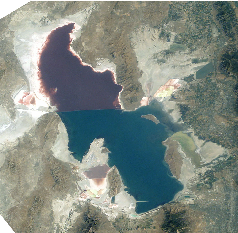
- Description:
- Great Salt Lake, Utah, to the right (east) are the Wasatch Mountains, to the lower right is Salt Lake City, Utah. This photo is taken from the International Space Station from approximately 380 km. The railway clearly separates the north and south sections of the lake, which have different salt concentrations due to the barrier. The northern section ( Gunnison Bay) is at least two times more salty than the southern one, and shows a pink or mauve color. The water level of the lake is very low: note that the northeast arm of the lake has disappeared, and that Antelope Island is no longer an island at all.
- Sequence of landforms (west-to-east), north:
en:Curlew Valley, en:Hansel Mountains, Hansel Valley, North Promontory Mountains, en:Blue Creek Valley, Blue Spring Hills, Penrose-Bothwell, Utah - Islands:
en:Stansbury Island, en:Antelope Island, en:Fremont Island-(north) - Sequence, south:
(en:Lakeside Mountains), en:Cedar Mountains (Tooele County), en:Skull Valley (Utah), en:Stansbury Mountains, Tooele Valley, en:Oquirrh Mountains, SLC - West lake: en:Hogup Mountains, (northwest), en:Lakeside Mountains, (southwest)
- Lake center: en:Promontory Mountains
- Sequence of landforms (west-to-east), north:
- Date: 19 August 2003, GMT time: 16:37
- Colors adapted: geographically coded
- Great Salt Lake, Utah, to the right (east) are the Wasatch Mountains, to the lower right is Salt Lake City, Utah. This photo is taken from the International Space Station from approximately 380 km. The railway clearly separates the north and south sections of the lake, which have different salt concentrations due to the barrier. The northern section ( Gunnison Bay) is at least two times more salty than the southern one, and shows a pink or mauve color. The water level of the lake is very low: note that the northeast arm of the lake has disappeared, and that Antelope Island is no longer an island at all.
- Source:
- NASA's Earth Observatory [1]
- License:
| Public domainPublic domainfalsefalse |
| 本作品由NASA創作,屬於公有領域。根據NASA的版權政策:“NASA的創作除非另有聲明否則不受版權保護。”(參見:Template:PD-USGov/zh,NASA版權政策或JPL圖像使用政策) | ||
 |
警告:
|
From : http://en.wikipedia.org/wiki/Image:Great_Salt_Lake_ISS_2003.JPG
| 註解 InfoField | 該圖片含有註解:在維基媒體共享資源上查看註解 |
221
442
312
42
996
976
Lucin Cutoff
666
556
125
213
996
976
Antelope Island State Park
說明
添加單行說明來描述出檔案所代表的內容
The Great Salt Lake (an endorheic lake) in Utah, taken from the International space station.
Большое Солёное Озеро , США, фото с МКС
image/jpeg
檔案歷史
點選日期/時間以檢視該時間的檔案版本。
| 日期/時間 | 縮圖 | 尺寸 | 使用者 | 備註 | |
|---|---|---|---|---|---|
| 目前 | 2005年11月11日 (五) 09:09 | | 996 × 976(248 KB) | Urban~commonswiki | Great Salt Lake from German Wikipedia * Description: ** Great Salt Lake, Utah, to the right (east) are the Wasatch Mountains, to the lower right is Salt Lake City, Utah. This photo is taken from the International Space Station from a |
檔案用途
下列頁面有用到此檔案:
全域檔案使用狀況
以下其他 wiki 使用了這個檔案:
- ar.wikipedia.org 的使用狀況
- arz.wikipedia.org 的使用狀況
- az.wikipedia.org 的使用狀況
- be.wikipedia.org 的使用狀況
- bn.wikipedia.org 的使用狀況
- br.wikipedia.org 的使用狀況
- ceb.wikipedia.org 的使用狀況
- cv.wikipedia.org 的使用狀況
- da.wikipedia.org 的使用狀況
- de.wikipedia.org 的使用狀況
- el.wikipedia.org 的使用狀況
- en.wikipedia.org 的使用狀況
- Jim Bridger
- Endorheic basin
- User:Cool Hand Luke/Photos
- Portal:United States/Selected article/2006, week 37
- Portal:United States/Selected article/2006, week 38
- Portal:United States/Selected article/2006, week 39
- Portal:United States/Selected article/2006, week 40
- Wikipedia:WikiProject Lakes/Galleries/1
- Endorheic lake
- Blue Creek Valley
- eo.wikipedia.org 的使用狀況
- es.wikipedia.org 的使用狀況
- et.wikipedia.org 的使用狀況
- fa.wikipedia.org 的使用狀況
- fi.wikipedia.org 的使用狀況
- fr.wikipedia.org 的使用狀況
- Grand Lac Salé
- Portail:États-Unis/Articles de qualité
- Lac Bonneville
- Wikipédia:Lumière sur/Juin 2008
- Wikipédia:Lumière sur/Grand Lac Salé
- Wikipédia:Sélection/Géographie
- Wikipédia:Sélection/Eau
- Wikipédia:Sélection/Utah
- Portail:Information géographique/Sélection
- Portail:Lacs et cours d'eau
- Wikipédia:Sélection/Lacs et cours d'eau
- Portail:Salt Lake City
- Wikipédia:Sélection/Salt Lake City
- Wikipédia:Sélection/États-Unis/Bons articles/Partie II
- Julie Moschelesová
- he.wikipedia.org 的使用狀況
- hi.wikipedia.org 的使用狀況
- hu.wikipedia.org 的使用狀況
檢視此檔案的更多全域使用狀況。
詮釋資料
此檔案中包含其他資訊,這些資訊可能是由數位相機或掃描器在建立或數位化過程中所新增的。若檔案自原始狀態已被修改,一些詳細資料可能無法完整反映出已修改的檔案。
| 方位 | 標準 |
|---|---|
| 水平解析度 | 300 dpi |
| 垂直解析度 | 300 dpi |
| 使用軟體 | Adobe Photoshop 7.0 |
| 檔案修改日期時間 | 2004年1月9日 (五) 11:45 |
| 色彩空間 | 顏色未校準 |