File:Gr-triple-occupation-ES.png
維基百科,自由的 encyclopedia
預覽大小:588 × 600 像素。 其他解析度:235 × 240 像素 | 471 × 480 像素 | 899 × 917 像素。
原始檔案 (899 × 917 像素,檔案大小:81 KB,MIME 類型:image/png)
| 描述Gr-triple-occupation-ES.png |
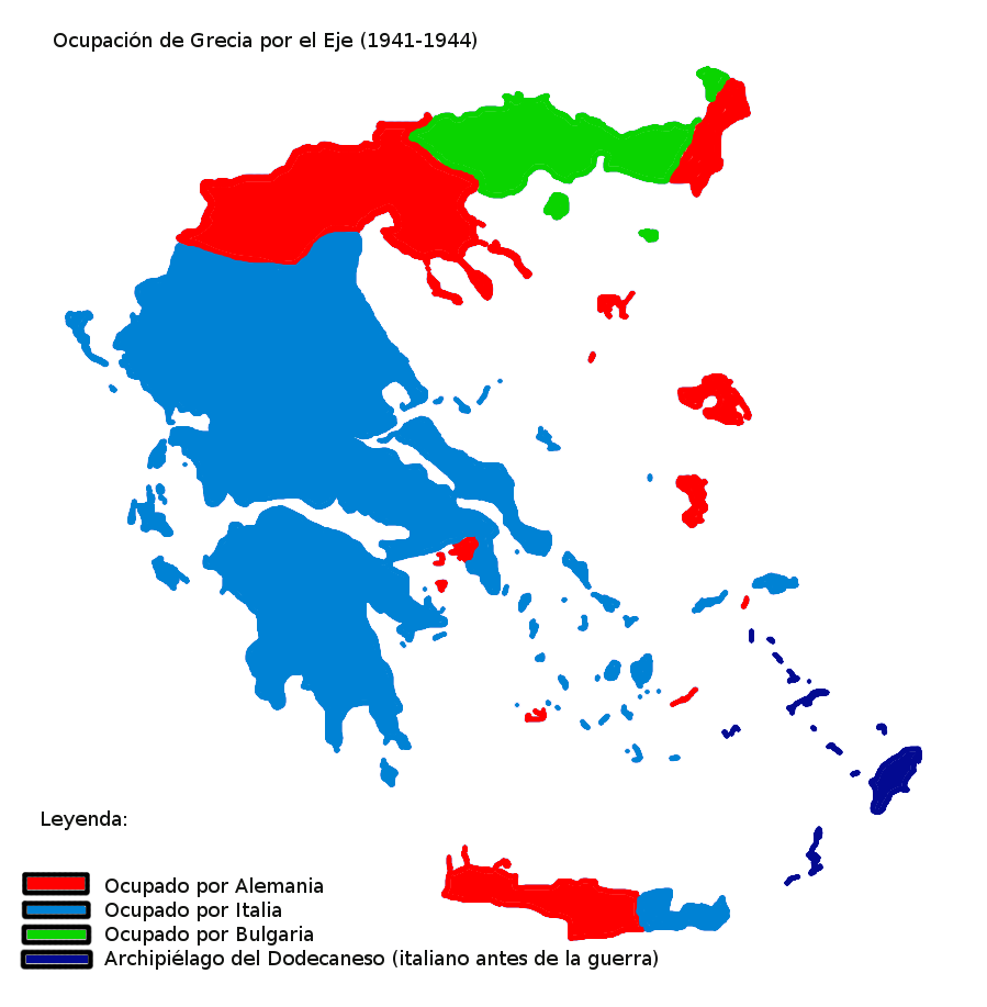
Map showning the zones of control of the three occupying powers in Greece during WW2, from 1941 to 1944. English: Map of Occupied Greece showing the German and Italian occupation zones on Crete. Svenska: Axelmakternas ockupationszoner under andra världskriget: blått Italien, grönt Bulgarien och rött Tyskland Türkçe: Üçlü işgâl sürecinde Yunanistan
Español: Mapa de las zonas de ocupación en las que se dividió Grecia durante la Segunda Guerra Mundial (1941-1944). |
| 日期 | (UTC) |
| 來源 | |
| 作者 |
|
| 其他版本 |
[編輯]
|


_-fr.png)


| 這是一張修飾過的圖片,即本圖片是用軟體修改過後的版本,修改的方式或內容有:Spanish version。原版圖片來源:Gr-triple-occupation.png。修改者:Rowanwindwhistler。
|
我,本作品的著作權持有者,決定用以下授權條款發佈本作品:
| 此檔案採用創用CC 姓名標示-相同方式分享 3.0 未在地化版本授權條款。 | ||
| ||
| 已新增授權條款標題至此檔案,作為GFDL授權更新的一部份。http://creativecommons.org/licenses/by-sa/3.0/CC BY-SA 3.0Creative Commons Attribution-Share Alike 3.0truetrue |

|
已授權您依據自由軟體基金會發行的無固定段落、封面文字和封底文字GNU自由文件授權條款1.2版或任意後續版本,對本檔進行複製、傳播和/或修改。該協議的副本列在GNU自由文件授權條款中。http://www.gnu.org/copyleft/fdl.htmlGFDLGNU Free Documentation Licensetruetrue |
您可以選擇您需要的授權條款。
原始上傳日誌
This image is a derivative work of the following images:
- File:Gr-triple-occupation.png licensed with Cc-by-sa-3.0-migrated, GFDL
- 2006-05-22T15:48:03Z GhePeU 899x917 (83492 Bytes) slightly reworked image
- 2005-07-02T16:06:06Z Michalis Famelis 899x917 (109852 Bytes) Map showning the zones of control of the three occupying powers in Greece during WW2, from 1941 to 1944. The image was created by me using another map as a template. This image was created using the Gimp. {{GFDL}}
Uploaded with derivativeFX
說明
添加單行說明來描述出檔案所代表的內容
在此檔案描寫的項目
描繪內容
27 1 2010
image/png
檔案歷史
點選日期/時間以檢視該時間的檔案版本。
| 日期/時間 | 縮圖 | 尺寸 | 使用者 | 備註 | |
|---|---|---|---|---|---|
| 目前 | 2010年1月27日 (三) 19:11 | | 899 × 917(81 KB) | Rowanwindwhistler | {{Information |Description=Map showning the zones of control of the three occupying powers in Greece during WW2, from 1941 to 1944. {{en|Map of Occupied Greece showing the German and Italian occupation zones on Crete.}} {{sv|Axelmakternas ockupationszoner |
檔案用途
沒有使用此檔案的頁面。
全域檔案使用狀況
以下其他 wiki 使用了這個檔案:
- gl.wikipedia.org 的使用狀況