File:Former_eastern_territories_of_Germany.png
維基百科,自由的 encyclopedia
預覽大小:735 × 600 像素。 其他解析度:294 × 240 像素 | 588 × 480 像素 | 794 × 648 像素。
原始檔案 (794 × 648 像素,檔案大小:63 KB,MIME 類型:image/png)

|
本圖片是以PNG、GIF或JPEG格式上傳。然而,其中包含的資料或訊息,應該重新建立成可縮放向量圖形(SVG)檔案,以更有效率或更準確的方式儲存。如有可能,請上傳本圖片的SVG格式版本。在上傳之後,請修改維基各姊妹計畫中所有使用舊版圖片的條目(列在圖像連結章節中),替換為新版圖片,並在舊圖片的描述頁中加入{{Vector version available|新圖片名稱.svg}}模板,同時移除本模板。
|
摘要
| 描述Former eastern territories of Germany.png |
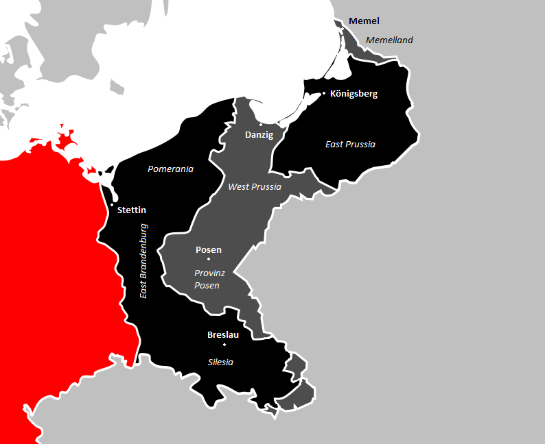
Deutsch: Ehemalige Ostgebiete Deutschlands, Nahaufnahme. Das heutige Deutschland in Rot, nach dem 2. Weltkrieg verlorenes Land in schwarz, nach dem 1. Weltkrieg verlorenes Land in dunkelgrau.
English: Former eastern territories of Germany, close-up. Present-day Germany in red, land lost after WW2 in black, land lost after WW1 in dark gray.
Español: Antiguos territorios orientales de Alemania, primer plano. La Alemania actual en rojo, la tierra perdida después de la Segunda Guerra Mundial en negro, la tierra perdida después de la Primera Guerra Mundial en gris oscuro.
|
| 日期 | |
| 來源 | 自己的作品 |
| 作者 | Ernio48 |
授權條款
我,本作品的著作權持有者,決定用以下授權條款發佈本作品:
此檔案採用創用CC 姓名標示-相同方式分享 4.0 國際授權條款。
- 您可以自由:
- 分享 – 複製、發佈和傳播本作品
- 重新修改 – 創作演繹作品
- 惟需遵照下列條件:
- 姓名標示 – 您必須指名出正確的製作者,和提供授權條款的連結,以及表示是否有對內容上做出變更。您可以用任何合理的方式來行動,但不得以任何方式表明授權條款是對您許可或是由您所使用。
- 相同方式分享 – 如果您利用本素材進行再混合、轉換或創作,您必須基於如同原先的相同或兼容的條款,來分布您的貢獻成品。
說明
添加單行說明來描述出檔案所代表的內容
Former eastern territories of Germany, close-up. Present-day Germany in red, land lost after WW2 in black, land lost after WW1 in dark gray.
Ehemalige Ostgebiete Deutschlands, Nahaufnahme. Das heutige Deutschland in Rot, nach dem 2. Weltkrieg verlorenes Land in schwarz, nach dem 1. Weltkrieg verlorenes Land in dunkelgrau.
Ex territori orientali della Germania, primo piano. La Germania di oggi in rosso, la terra perduta dopo la seconda guerra mondiale in nero, la terra perduta dopo la prima guerra mondiale in grigio scuro.
Antiguos territorios orientales de Alemania, primer plano. La Alemania actual en rojo, la tierra perdida después de la Segunda Guerra Mundial en negro, la tierra perdida después de la Primera Guerra Mundial en gris oscuro.
Voormalige oostelijke gebieden van Duitsland, close-up. Het huidige Duitsland in rood, land verloren na WO2 in zwart, land verloren na WO1 in donkergrijs.
Antigos territórios orientais da Alemanha, primeiro plano. A Alemanha de hoje em vermelho, a terra perdida após a Segunda Guerra Mundial em preto, a terra perdida após a Primeira Guerra Mundial em cinza escuro.
Tidligere østlige territorier i Tyskland, nærbillede. Dagens Tyskland i rødt, land tabt efter 2. verdenskrig i sort, land tabt efter 1. verdenskrig i mørkegrå.
在此檔案描寫的項目
描繪內容
11 2 2017
image/png
檔案歷史
點選日期/時間以檢視該時間的檔案版本。
| 日期/時間 | 縮圖 | 尺寸 | 使用者 | 備註 | |
|---|---|---|---|---|---|
| 目前 | 2018年5月19日 (六) 15:53 | | 794 × 648(63 KB) | Ernio48 | Major cities, names of regions. |
| 2018年5月1日 (二) 20:07 |  | 794 × 648(53 KB) | Ernio48 | No Austro-Hungarian/Russian boundary. | |
| 2017年2月12日 (日) 02:10 |  | 794 × 648(51 KB) | Ernio48 | Making a difference between land lost in WW1 and WW2. | |
| 2017年2月11日 (六) 22:55 |  | 726 × 592(38 KB) | Ernio48 | User created page with UploadWizard |
檔案用途
下列頁面有用到此檔案:
全域檔案使用狀況
以下其他 wiki 使用了這個檔案:
- ar.wikipedia.org 的使用狀況
- cs.wikipedia.org 的使用狀況
- de.wikipedia.org 的使用狀況
- en.wikipedia.org 的使用狀況
- eo.wikipedia.org 的使用狀況
- es.wikipedia.org 的使用狀況
- et.wikipedia.org 的使用狀況
- fa.wikipedia.org 的使用狀況
- fi.wikipedia.org 的使用狀況
- fy.wikipedia.org 的使用狀況
- he.wikipedia.org 的使用狀況
- ja.wikipedia.org 的使用狀況
- pl.wikipedia.org 的使用狀況
- pt.wikipedia.org 的使用狀況
- simple.wikipedia.org 的使用狀況
- www.wikidata.org 的使用狀況
詮釋資料
此檔案中包含其他資訊,這些資訊可能是由數位相機或掃描器在建立或數位化過程中所新增的。若檔案自原始狀態已被修改,一些詳細資料可能無法完整反映出已修改的檔案。
| 水平解析度 | 37.8 dpc |
|---|---|
| 垂直解析度 | 37.8 dpc |