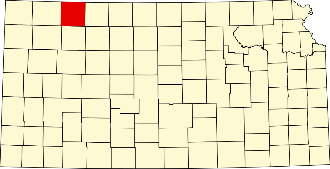
第開特縣(英語:Decatur County,簡稱DC)是美國堪薩斯州西北部的一個縣,北鄰內布拉斯加州。面積2,316平方公里。根據美國2000年人口普查,共有人口3,472人。縣治奧伯林 (Oberlin)。
成立於1873年3月20日,縣政府成立於1879年12月15日。本縣紀念1812年戰爭英雄史提芬·迪卡特 (Stephen Decatur)。[1]
鎮內分區
- 奧巴林 (Oberlin,縣治)
- 挪卡特 (Norcatur)
- 詹寧斯 (Jennings)
- 克雷頓 (Clayton)
- 德勒斯登(Dresden)
- 阿利森 (Allison)
- 賒達布魯夫斯(Cedar Bluffs)
- 卡奴拿 (Kanona)
- 里奧維爾利 (Leoville)
- 賴奧 (Lyle)
- 特尼沙 (Traer)
迪卡特縣被劃為 25 個鎮區。奧巴林屬於「政府獨立」因而沒有進行鎮區的人口普查。
| Township | FIPS | Population center |
Population | Population density /km² (/sq mi) |
Land area km² (sq mi) |
Water area km² (sq mi) |
Water % | Geographic coordinates |
|---|---|---|---|---|---|---|---|---|
| Allison | 01300 | 39 | 0 (1) | 93 (36) | 0 (0) | 0.01% | 39°35′36″N 100°12′24″W | |
| Altory | 01650 | 16 | 0 (0) | 93 (36) | 0 (0) | 0 % | 39°47′22″N 100°21′15″W | |
| Bassettville | 04475 | 26 | 0 (1) | 93 (36) | 0 (0) | 0 % | 39°41′12″N 100°40′38″W | |
| Beaver | 05050 | 86 | 1 (2) | 92 (36) | 0 (0) | 0.11% | 39°58′42″N 100°34′2″W | |
| Center | 11650 | 60 | 1 (2) | 93 (36) | 0 (0) | 0.03% | 39°47′5″N 100°27′38″W | |
| Cook | 15375 | 44 | 0 (1) | 93 (36) | 0 (0) | 0.08% | 39°36′16″N 100°40′32″W | |
| Custer | 16850 | 27 | 0 (1) | 93 (36) | 0 (0) | 0.04% | 39°41′17″N 100°26′59″W | |
| Dresden | 18625 | 141 | 2 (4) | 92 (36) | 0 (0) | 0.01% | 39°36′39″N 100°27′5″W | |
| Finley | 23425 | 39 | 0 (1) | 93 (36) | 0 (0) | 0 % | 39°57′42″N 100°41′20″W | |
| Garfield | 25525 | 41 | 0 (1) | 92 (36) | 0 (0) | 0 % | 39°46′38″N 100°14′44″W | |
| Grant | 27600 | 31 | 0 (1) | 92 (36) | 0 (0) | 0.07% | 39°57′36″N 100°14′11″W | |
| Harlan | 30050 | 51 | 1 (1) | 92 (36) | 0 (0) | 0.05% | 39°56′50″N 100°20′56″W | |
| Jennings | 35400 | 173 | 2 (5) | 93 (36) | 0 (0) | 0.34% | 39°40′35″N 100°18′56″W | |
| Liberty | 39975 | 48 | 1 (1) | 91 (35) | 0 (0) | 0.03% | 39°53′2″N 100°33′31″W | |
| Lincoln | 40600 | 203 | 2 (6) | 92 (36) | 0 (0) | 0.02% | 39°50′58″N 100°12′21″W | |
| Logan | 41825 | 52 | 1 (1) | 93 (36) | 0 (0) | 0 % | 39°52′38″N 100°42′42″W | |
| Lyon | 43450 | 24 | 0 (1) | 93 (36) | 0 (0) | 0 % | 39°36′52″N 100°21′8″W | |
| Oberlin | 52025 | 91 | 1 (3) | 89 (34) | 0 (0) | 0.08% | 39°47′32″N 100°34′20″W | |
| Olive | 52675 | 68 | 1 (2) | 92 (35) | 1 (0) | 0.65% | 39°51′43″N 100°28′18″W | |
| Pleasant Valley | 56525 | 46 | 0 (1) | 93 (36) | 0 (0) | 0.05% | 39°41′53″N 100°13′59″W | |
| Prairie Dog | 57475 | 50 | 1 (1) | 93 (36) | 0 (0) | 0.01% | 39°36′33″N 100°33′49″W | |
| Roosevelt | 61025 | 32 | 0 (1) | 93 (36) | 0 (0) | 0.07% | 39°53′1″N 100°21′43″W | |
| Sappa | 63050 | 43 | 0 (1) | 93 (36) | 0 (0) | 0.04% | 39°45′57″N 100°41′48″W | |
| Sherman | 64900 | 25 | 0 (1) | 92 (36) | 0 (0) | 0.01% | 39°57′5″N 100°28′7″W | |
| Summit | 69075 | 22 | 0 (1) | 93 (36) | 0 (0) | 0.09% | 39°41′27″N 100°34′37″W | |
| Sources: Census 2000 U.S. Gazetteer Files. U.S. Census Bureau, Geography Division. [2007-11-21]. (原始內容存檔於2012-04-26). | ||||||||
人口

參考文獻
Wikiwand in your browser!
Seamless Wikipedia browsing. On steroids.
Every time you click a link to Wikipedia, Wiktionary or Wikiquote in your browser's search results, it will show the modern Wikiwand interface.
Wikiwand extension is a five stars, simple, with minimum permission required to keep your browsing private, safe and transparent.


