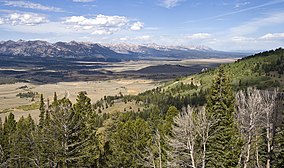
锯齿国家森林
来自维基百科,自由的百科全书
锯齿国家森林(英语:Sawtooth National Forest)是一座美国国家森林,占地面积2,110,408英亩(8,540.52平方千米),其中有约96%位于爱达荷州,4%位于犹他州。森林由美国农业部下属的美国国家森林局管理,原在1905年5月29日、西奥多·罗斯福美国总统签署法令设立保护区时曾名“锯齿森林保护区”(Sawtooth Forest Reserve)。1972年8月22日,部分森林被划为锯齿国家休闲区。
此条目可参照英语维基百科相应条目来扩充,此条目在对应语言版为高品质条目。 |
参考资料
外部链接
Wikiwand in your browser!
Seamless Wikipedia browsing. On steroids.
Every time you click a link to Wikipedia, Wiktionary or Wikiquote in your browser's search results, it will show the modern Wikiwand interface.
Wikiwand extension is a five stars, simple, with minimum permission required to keep your browsing private, safe and transparent.


