File:World_in_820.png
维基百科,自由的 encyclopedia
本预览的尺寸:800 × 400像素。 其他分辨率:320 × 160像素 | 640 × 320像素。
原始文件 (1,200 × 600像素,文件大小:42 KB,MIME类型:image/png)
摘要
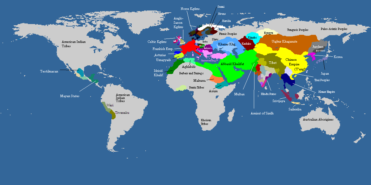
| 描述World in 820.png |
Deutsch: Weltkarte, ca. um 820 n.Chr. Farbige Gebiete zeigen den Einfluss von grösseren Mächten in dieser Zeit, die Kontrolle über manche dieser Gebiete sind z.T. nur nominell vorhanden. Graue Gebiete waren entweder vorwiegend von Ureinwohnern besiedelt oder unbewohnt.
English: Map of the world, c. AD 820. Colored areas show the extent of influence for the major empires of the period; control over some areas may have been purely nominal. Gray areas showed areas that are mainly inhabited by Indigineous populations, or completely uninhabited.
한국어: 서기 820년의 세계지도입니다. 색깔이 있는 지역은 이 시대의 현존했던 왕국과 제국의 영향력을 보여주는 것입니다. 회색지역은 인디언이나 국가가 없던 지역이거나 혹은 사람이 살지 않은 곳입니다. |
||
| 日期 | not stated | ||
| 来源 | from academic sources | ||
| 作者 | multiple authors | ||
| 其他版本 |
|

| Maps of world history | |
| BC | |
|
| |
| AD |
1 · 50 · 100 · 200 · 250 · 300 · 400 · 500 · 700 · 750 · 820 · 900 · 1200 · 1500 · 1556 · 1648 · 1700 · 1750 · 1815 · 1859 · 1871 · 1914 · 1935 · 1954 · 1989 · 2000 · |
|
Maps of colonization history | |
|
see also: Eastern Hemisphere only maps template (1300BC-1500AD) | |
| (this template: · view · discuss ) | |
.jpg)
._LOC_2001620596.jpg)

|
此historical map图片可使用矢量图形重新创建为SVG文件。这具有很多好处;更多信息请参见共享资源:待清理媒体。如果存在此图片的SVG格式,请将其上传,然后将此模板替换为
{{vector version available|新图片名称}}。
建议您将SVG命名为“World in 820.svg”,这样在使用Vector version available(或Vva)模板时就不需要填写新图片名称参数。 |
许可协议
| 本文件采用知识共享署名-相同方式共享 3.0 未本地化版本许可协议授权。 受免責聲明的約束。 | ||
| ||
| 本许可协议标签作为GFDL许可协议更新的组成部分被添加至本文件。http://creativecommons.org/licenses/by-sa/3.0/CC BY-SA 3.0Creative Commons Attribution-Share Alike 3.0truetrue |

|
已授权您依据自由软件基金会发行的无固定段落及封面封底文字(Invariant Sections, Front-Cover Texts, and Back-Cover Texts)的GNU自由文件许可协议1.2版或任意后续版本的条款,复制、传播和/或修改本文件。该协议的副本请见“GNU Free Documentation License”。 受免責聲明的約束。http://www.gnu.org/copyleft/fdl.htmlGFDLGNU Free Documentation Licensetruetrue |
说明
添加一行文字以描述该文件所表现的内容
此文件中描述的项目
描绘内容
文件历史
点击某个日期/时间查看对应时刻的文件。
| 日期/时间 | 缩略图 | 大小 | 用户 | 备注 | |
|---|---|---|---|---|---|
| 当前 | 2022年11月20日 (日) 10:06 | | 1,200 × 600(42 KB) | Roy17 | Reverted to version as of 15:56, 11 May 2009 (UTC) Commons:Overwriting existing files ✘ Major changes (e.g. a radical crop) |
| 2019年11月16日 (六) 12:52 |  | 4,974 × 2,519(629 KB) | Anchuhu | [[Media:]] | |
| 2016年8月10日 (三) 12:44 |  | 646 × 408(27 KB) | Garam | Reverted to version as of 13:11, 11 July 2012 (UTC) | |
| 2013年12月14日 (六) 14:28 |  | 1,170 × 486(40 KB) | Billinghurst | Reverted to version as of 00:40, 7 June 2009, prior to expansion to other areas | |
| 2012年7月11日 (三) 13:11 |  | 646 × 408(27 KB) | Runehelmet | updated | |
| 2011年4月11日 (一) 08:30 |  | 644 × 408(15 KB) | Garam | Fix. (The northern area of Taedong River is Balhae territory. Now version border is Goryeo territory.) | |
| 2011年4月10日 (日) 09:21 |  | 644 × 408(15 KB) | Garam | Fix the name (Goryeo - A.D. 918 ~ A.D. 1392, Silla - B.C. 57 ~ A.D. 935, Later Three Kingdoms - A.D. 892 ~ A.D. 936) | |
| 2010年3月19日 (五) 17:19 |  | 644 × 408(10 KB) | Aiyizo | compressed with pngout | |
| 2010年1月17日 (日) 19:29 |  | 644 × 408(30 KB) | Ecthelion83 | Reverted to version as of 19:28, 17 January 2010 | |
| 2010年1月17日 (日) 19:29 |  | 644 × 408(30 KB) | Ecthelion83 | Reverted to version as of 19:27, 17 January 2010 |
文件用途
没有页面使用本文件。
全域文件用途
以下其他wiki使用此文件:
- en.wikipedia.org上的用途
- es.wikipedia.org上的用途