File:WW2-Holocaust-Europe_DE.png
维基百科,自由的 encyclopedia
本预览的尺寸:721 × 600像素。 其他分辨率:289 × 240像素 | 577 × 480像素 | 923 × 768像素 | 1,231 × 1,024像素 | 1,310 × 1,090像素。
原始文件 (1,310 × 1,090像素,文件大小:802 KB,MIME类型:image/png)
| 描述WW2-Holocaust-Europe DE.png |
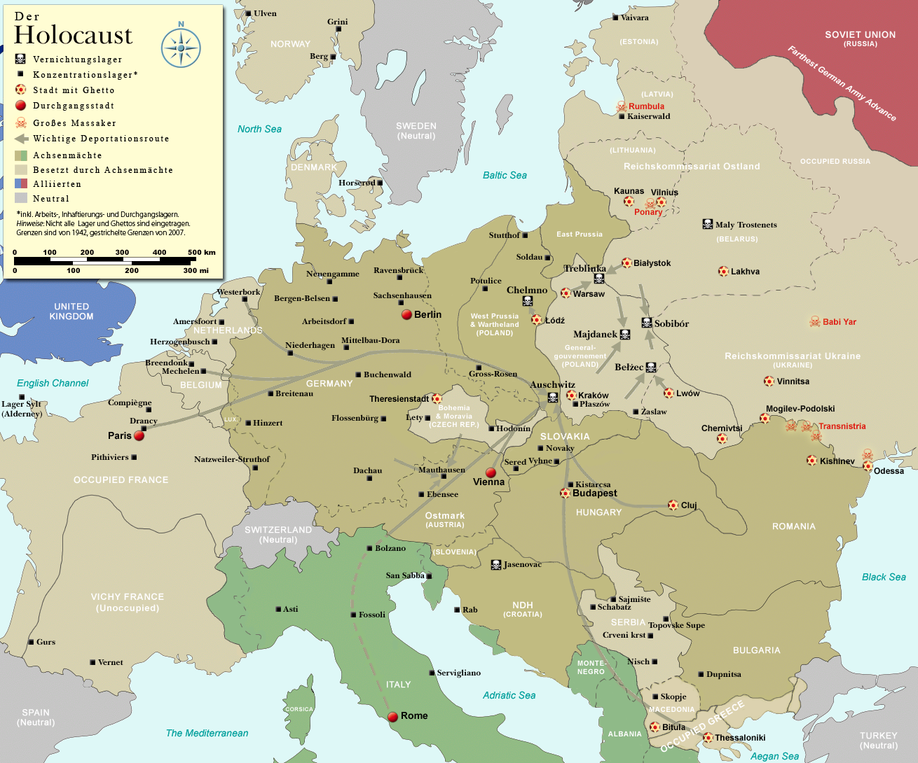
English: Map of the Holocaust in Europe during World War II, 1939-1945. This map shows all extermination camps (or death camps), most major concentration camps, labor camps, prison camps, ghettos, major deportation routes and major massacre sites. Notes: 1. Extermination camps were dedicated death camps, but all camps and ghettos took a toll of many, many lives. 2. Concentration camps include labor camps, prison camps & transit camps. 3. Not all camps & ghettos are shown. 4. Borders are at the height of Axis domination (1942). 5. Some regions have German designations (e.g. "Ostland"), with the present country name denoted in uppercase letters in parenthesis below the German designation (e.g. "(AUSTRIA)"). 6. Present (2007) borders are dotted. |
| 日期 | (UTC) |
| 来源 | |
| 作者 |
|
| 其他版本 |
[编辑]
|


.png)


.png)


| 这是一张修改过的图片,这意味着它已在原版本的基础上通过软件进行了编辑,改动内容:german legend。其原始版本为:WW2-Holocaust-Europe.png。修改者:Emdee。
|
我,本作品著作权人,特此采用以下许可协议发表本作品:
本文件采用知识共享署名 3.0 未本地化版本许可协议授权。
- 您可以自由地:
- 共享 – 复制、发行并传播本作品
- 修改 – 改编作品
- 惟须遵守下列条件:
- 署名 – 您必须对作品进行署名,提供授权条款的链接,并说明是否对原始内容进行了更改。您可以用任何合理的方式来署名,但不得以任何方式表明许可人认可您或您的使用。
原始上传日志
This image is a derivative work of the following images:
- File:WW2-Holocaust-Europe.png licensed with Cc-by-3.0
- 2007-12-20T03:41:38Z Dna-webmaster 1310x1090 (845818 Bytes) new version without "Axis cooperating" in legend
- 2007-12-20T02:00:30Z Dna-webmaster 1310x1090 (844034 Bytes) Now entire West Prussia and Wartheland is included in the Third Reich
- 2007-12-19T16:42:15Z Dna-webmaster 1310x1090 (847461 Bytes) still not Da Vinci, but errors have been corrected (Germany borders West/East), West & East Prussia borders/coloring and Poland General Government corrected borders.
- 2007-12-17T10:46:28Z Dna-webmaster 1310x1090 (844633 Bytes) new map with 1942 borders, not Da Vinci, but here it goes...
- 2007-10-19T13:32:25Z Dna-webmaster 1310x1090 (784727 Bytes) and another update
- 2007-10-19T12:21:52Z Dna-webmaster 1310x1090 (789383 Bytes) quick fix
- 2007-10-19T12:11:07Z Dna-webmaster 1310x1090 (789413 Bytes) {{Information |Description=Map of the Holocaust in Europe during World War II, 1939-1945. This map shows all extermination camps (or ''death camps''), most major concentration camps, work camps, prison camps, ghettos, major
Uploaded with derivativeFX
说明
添加一行文字以描述该文件所表现的内容
此文件中描述的项目
描绘内容
21 7 2009
文件历史
点击某个日期/时间查看对应时刻的文件。
| 日期/时间 | 缩略图 | 大小 | 用户 | 备注 | |
|---|---|---|---|---|---|
| 当前 | 2009年7月21日 (二) 21:54 | | 1,310 × 1,090(802 KB) | Emdee | argh |
| 2009年7月21日 (二) 21:44 |  | 1,310 × 1,090(802 KB) | Emdee | {{Information |Description={{en|Map of the Holocaust in Europe during World War II, 1939-1945. <br /> This map shows all extermination camps (or ''death camps''), most major concentration camps, labor camps, prison camps, ghettos, major deportation routes |
文件用途
没有页面使用本文件。
全域文件用途
以下其他wiki使用此文件:
- de.wikipedia.org上的用途
- uk.wikipedia.org上的用途