File:NPS_jewel-cave-layout-map.pdf
维基百科,自由的 encyclopedia
此PDF文件的JPG预览的大小:671 × 599像素。 其他分辨率:269 × 240像素 | 538 × 480像素 | 739 × 660像素。
原始文件 (739 × 660像素,文件大小:7.21 MB,MIME类型:application/pdf)
摘要
| 描述NPS jewel-cave-layout-map.pdf |
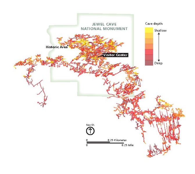
English: Jewel Cave underground map, showing the passageways, tunnels, and chambers that make up the Jewel Cave complex . |
| 日期 | |
| 来源 | U.S. National Park Service (http://npmaps.com/wp-content/uploads/jewel-cave-layout-map.pdf) |
| 作者 | U.S. National Park Service, restoration/cleanup by Matt Holly |
| 其他版本 |
 |
许可协议
| Public domainPublic domainfalsefalse |
| This image or media file contains material based on a work of a National Park Service employee, created as part of that person's official duties. As a work of the U.S. federal government, such work is in the public domain in the United States. See the NPS website and NPS copyright policy for more information. |
说明
添加一行文字以描述该文件所表现的内容
此文件中描述的项目
描绘内容
22 4 2016
文件历史
点击某个日期/时间查看对应时刻的文件。
| 日期/时间 | 缩略图 | 大小 | 用户 | 备注 | |
|---|---|---|---|---|---|
| 当前 | 2017年5月17日 (三) 00:17 |  | 739 × 660(7.21 MB) | RKBot | =={{int:filedesc}}== {{Information |description= {{en|1=Jewel Cave underground map, showing the passageways, tunnels, and chambers that make up the Jewel Cave complex .}} |date= 2016-04-22 |source= U.S. National Park Service (http://npmaps.com/wp-conte... |
文件用途
以下页面使用本文件:
元数据
此文件含有额外信息,这些信息可能是创建或数字化该文件时使用的数码相机或扫描仪所添加的。如果文件已从其原始状态修改,某些详细信息可能无法完全反映修改后的文件。
| 简短标题 |
|
|---|---|
| 使用软件 | Adobe Illustrator CC 2015 (Macintosh) |
| 数字化日期时间 | 2016年3月1日 (二) 10:16 |
| 文件修改日期时间 | 2016年3月1日 (二) 10:17 |
| 元数据最后修改日期 | 2016年3月1日 (二) 10:17 |
| 原始文件唯一ID | uuid:371CA28B97F411DB98E8DD0A81278AD8 |
| 转换程序 | Adobe PDF library 15.00 |
| 加密 | no |
| 页面大小 | 355.333 x 317.333 pts |
| PDF格式的版本 | 1.5 |