File:Karte_Adelaide_MKL1888.png
维基百科,自由的 encyclopedia
没有更高的分辨率。
Karte_Adelaide_MKL1888.png (365 × 539像素,文件大小:51 KB,MIME类型:image/png)
摘要
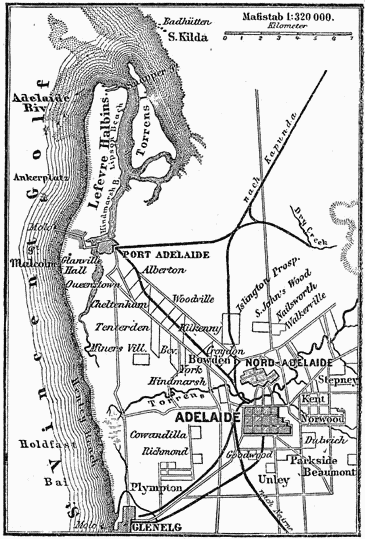
| 描述Karte Adelaide MKL1888.png |
Deutsch: Plan von Adelaide (1 : 320.000)
English: Map of Adelaide (1:320,000 scale) |
|||
| 日期 |
约1885年 date QS:P,+1885-00-00T00:00:00Z/9,P1480,Q5727902 |
|||
| 来源 |
|
|||
| 作者 | 未知Unknown author |

许可协议
| Public domainPublic domainfalsefalse |
| This image comes from the 4th edition of Meyers Konversationslexikon (1885–90). The copyrights have expired and this image is in the public domain. |
| Public domainPublic domainfalsefalse |
|
本作品在其来源国以及其他著作权期限是作者逝世后100年或以下的国家和地区属于公有领域。 | |
| 本文件已被确认为免除已知的著作权法限制(包括所有相关权利)。 | |
https://creativecommons.org/publicdomain/mark/1.0/PDMCreative Commons Public Domain Mark 1.0falsefalse
文件历史
点击某个日期/时间查看对应时刻的文件。
| 日期/时间 | 缩略图 | 大小 | 用户 | 备注 | |
|---|---|---|---|---|---|
| 当前 | 2004年12月11日 (六) 17:33 | | 365 × 539(51 KB) | ¡0-8-15! | {{Template:PD-Meyers}} |
文件用途
以下页面使用本文件:
全域文件用途
以下其他wiki使用此文件:
- ckb.wikipedia.org上的用途
- da.wikipedia.org上的用途
- de.wikipedia.org上的用途
- de.wikisource.org上的用途
- en.wikipedia.org上的用途
- fa.wikipedia.org上的用途
- fi.wikipedia.org上的用途
- lb.wikipedia.org上的用途
- ms.wikipedia.org上的用途