File:India_Red_Corridor_map.png
维基百科,自由的 encyclopedia
没有更高的分辨率。
India_Red_Corridor_map.png (530 × 599像素,文件大小:369 KB,MIME类型:image/png)
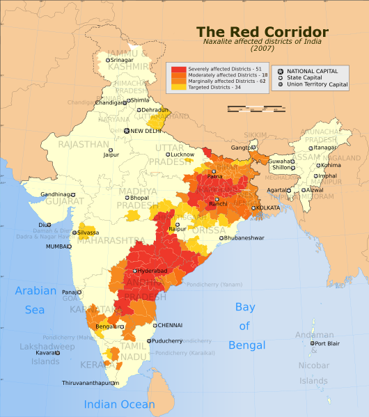
| 描述India Red Corridor map.png | The Red Corridor in 2007. A relatively underdeveloped region in eastern India that has w:Naxalite communist militant activity. |
| 日期 | (UTC) |
| 来源 | |
| 作者 |
|
| 这是一张修改过的图片,这意味着它已在原版本的基础上通过软件进行了编辑。其原始版本为:India Naxal affected districts map.svg。
|
我,本作品著作权人,特此采用以下许可协议发表本作品:
本文件采用知识共享署名-相同方式共享 3.0 未本地化版本许可协议授权。
- 您可以自由地:
- 共享 – 复制、发行并传播本作品
- 修改 – 改编作品
- 惟须遵守下列条件:
- 署名 – 您必须对作品进行署名,提供授权条款的链接,并说明是否对原始内容进行了更改。您可以用任何合理的方式来署名,但不得以任何方式表明许可人认可您或您的使用。
- 相同方式共享 – 如果您再混合、转换或者基于本作品进行创作,您必须以与原先许可协议相同或相兼容的许可协议分发您贡献的作品。

|
已授权您依据自由软件基金会发行的无固定段落及封面封底文字(Invariant Sections, Front-Cover Texts, and Back-Cover Texts)的GNU自由文件许可协议1.2版或任意后续版本的条款,复制、传播和/或修改本文件。该协议的副本请见“GNU Free Documentation License”。http://www.gnu.org/copyleft/fdl.htmlGFDLGNU Free Documentation Licensetruetrue |
您可以选择您需要的许可协议。
原始上传日志
This image is a derivative work of the following images:
- Image:India_Naxal_affected_districts_map.svg licensed with Cc-by-sa-3.0, GFDL
- 2007-03-27T09:04:49Z PlaneMad 1639x1852 (923243 Bytes) {{WikiProject_India_Maps |Title=Naxal Affected districts Map |Description=Map showing the districts in India affected by [[w:Naxals]]. |Source=CNN-IBN[http://www.ibnlive.com/news/naxals-vow-to-renew-red-terror/35121-3.html Na
Uploaded with derivativeFX
说明
添加一行文字以描述该文件所表现的内容
Marathi madhe oahije
此文件中描述的项目
描绘内容
27 10 2008
文件历史
点击某个日期/时间查看对应时刻的文件。
| 日期/时间 | 缩略图 | 大小 | 用户 | 备注 | |
|---|---|---|---|---|---|
| 当前 | 2008年10月27日 (一) 17:01 | | 530 × 599(369 KB) | Hunnjazal | {{Information |Description=The Red Corridor. A relatively underdeveloped region in eastern India that has w:Naxalite communist militant activity. |Source=*Image:India_Naxal_affected_districts_map.svg |Date=2008-10-27 16:58 (UTC) |Author=*derivat |
文件用途
没有页面使用本文件。
全域文件用途
以下其他wiki使用此文件:
- bn.wikipedia.org上的用途
- ca.wikipedia.org上的用途
- en.wikipedia.org上的用途
- es.wikipedia.org上的用途
- fr.wikipedia.org上的用途
- ta.wikipedia.org上的用途