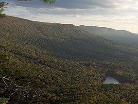
塔拉迪加国家森林
来自维基百科,自由的百科全书
塔拉迪加国家森林(英语:Talladega National Forest)位于美国亚拉巴马州阿巴拉契亚山脉南端,面积392,567英亩(158,866公顷)。[2]在被联邦政府收购前,森林曾一度遭滥砍滥伐。目前,这片土地长出了郁郁葱葱的松树林,也有着多种多样的生态系统。
| 塔拉迪加国家森林 | |
|---|---|
IUCN分类VI(资源管理保护区) | |
 亚拉巴马州的最高点——契哈山位于塔拉迪加国家森林内。 | |
| 位置 | |
| 最近城市 | 塔拉迪加 |
| 坐标 | 33°11′46″N 86°27′45″W |
| 面积 | 392,567英亩(1,588.66平方千米) |
| 建立 | 1936年7月17日[1] |
| 管理机构 | 美国国家森林局 |
| 网站 | http://www.fs.usda.gov/alabama |
参考资料
外部链接
Wikiwand in your browser!
Seamless Wikipedia browsing. On steroids.
Every time you click a link to Wikipedia, Wiktionary or Wikiquote in your browser's search results, it will show the modern Wikiwand interface.
Wikiwand extension is a five stars, simple, with minimum permission required to keep your browsing private, safe and transparent.

