File:WWII_Europe_1941-1942_Map_EN.png
维基百科,自由的 encyclopedia

本预览的尺寸:654 × 600像素。 其他分辨率:262 × 240像素 | 523 × 480像素 | 837 × 768像素 | 1,090 × 1,000像素。
原始文件 (1,090 × 1,000像素,文件大小:99 KB,MIME类型:image/png)

|
此military map图片可使用矢量图形重新创建为SVG文件。这具有很多好处;更多信息请参见共享资源:待清理媒体。如果存在此图片的SVG格式,请将其上传,然后将此模板替换为
{{vector version available|新图片名称}}。
建议您将SVG命名为“WWII Europe 1941-1942 Map EN.svg”,这样在使用Vector version available(或Vva)模板时就不需要填写新图片名称参数。 |
摘要
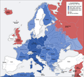
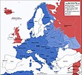
Ελληνικά: Εδαφικές κατακτήσεις του Ράιχ
Español: Conquistas territoriales del Reich
A map of German front of the Second World War circa 1941-1942. The original German-language map was created by User:San Jose on 17 April 2005. It can be found here.
This image is a translation of the original, created and released under the terms of the GNU Free Documentation License. It was created and uploaded by User:ArmadniGeneral on 22 December 2005.
| 这是一张修改过的图片,这意味着它已在原版本的基础上通过软件进行了编辑,改动内容:altered colors to reflect other map color schemes on the wiki page Nazi_Germany。其原始版本为:Second world war europe 1941-1942 map en.png。修改者:Ianjameslyon。
|
[编辑]
-
 Deutsch
 -
 English
 -
 English (alt)
 -
 polski
 -
 українська
 -
 հայերեն
 -
 中文(简体)
 -
 中文(繁體)


_en.png)
.png)
.jpg)
许可协议

|
已授权您依据自由软件基金会发行的无固定段落及封面封底文字(Invariant Sections, Front-Cover Texts, and Back-Cover Texts)的GNU自由文件许可协议1.2版或任意后续版本的条款,复制、传播和/或修改本文件。该协议的副本请见“GNU Free Documentation License”。http://www.gnu.org/copyleft/fdl.htmlGFDLGNU Free Documentation Licensetruetrue |
| 本文件采用知识共享署名-相同方式共享 3.0 未本地化版本许可协议授权。 | ||
| ||
| 本许可协议标签作为GFDL许可协议更新的组成部分被添加至本文件。http://creativecommons.org/licenses/by-sa/3.0/CC BY-SA 3.0Creative Commons Attribution-Share Alike 3.0truetrue |
说明
添加一行文字以描述该文件所表现的内容
此文件中描述的项目
描绘内容
知识共享署名-相同方式共享3.0未本地化版本 简体中文(已转写)
GNU自由文档许可证1.2或更高版本 简体中文(已转写)
image/png
文件历史
点击某个日期/时间查看对应时刻的文件。
| 日期/时间 | 缩略图 | 大小 | 用户 | 备注 | |
|---|---|---|---|---|---|
| 当前 | 2009年9月23日 (三) 09:37 | | 1,090 × 1,000(99 KB) | Ianjameslyon | == Summary == {{SVG|map}} {{el|Εδαφικές κατακτήσεις του Ράιχ}} {{es|Conquistas territoriales del Reich}} A map of German front of the Second World War circa 1941-1942. The original German-language map was created by [[User:San Jo |
文件用途
没有页面使用本文件。
全域文件用途
以下其他wiki使用此文件:
- cs.wikipedia.org上的用途
- pt.wikipedia.org上的用途
- rm.wikipedia.org上的用途
元数据
此文件中包含有扩展的信息。这些信息可能是由数码相机或扫描仪在创建或数字化过程中所添加。
如果此文件的源文件已经被修改,一些信息在修改后的文件中将不能完全反映出来。
| 使用软件 |
|---|