File:Saint_Kitts_and_Nevis-CIA_WFB_Map.png
维基百科,自由的 encyclopedia
此为最大尺寸。
Saint_Kitts_and_Nevis-CIA_WFB_Map.png (326 × 350像素,文件大小:6 KB,MIME类型:image/png)
| 描述Saint Kitts and Nevis-CIA WFB Map.png |
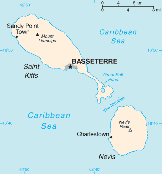
English: Map of the Saint Kitts and Nevis |
| 来源 |
The World Factbook The Central Intelligence Agency, Langley, Virginia, USA |
| 作者 | 未知Unknown author |
| 其他版本 | Image:Basseterre_Map_1.png |
| Public domainPublic domainfalsefalse |
|
Bahasa Indonesia ∙ čeština ∙ Deutsch ∙ eesti ∙ English ∙ español ∙ Esperanto ∙ français ∙ galego ∙ hrvatski ∙ italiano ∙ Nederlands ∙ norsk nynorsk ∙ polski ∙ português ∙ sicilianu ∙ slovenščina ∙ suomi ∙ Türkçe ∙ Zazaki ∙ беларуская (тарашкевіца) ∙ македонски ∙ русский ∙ српски / srpski ∙ українська ∙ ქართული ∙ বাংলা ∙ தமிழ் ∙ മലയാളം ∙ 한국어 ∙ 日本語 ∙ 中文 ∙ 中文(简体) ∙ 中文(繁體) ∙ العربية ∙ +/− |
 |
| date/time | username | edit summary |
|---|---|---|
| 01:08, 4. Nov 2004 | de:Benutzer:Zenogantner | |
| 23:47, 20. Okt 2003 | de:Benutzer:Head | (Karte Saint Kitts und Nevis, public domain aus dem CIA World Factbook: https://www.cia.gov/library/publications/the-world-factbook/geos/sc.html) |
原始上传日志
Legende: (Aktuell) = dies ist das aktuelle Bild, (Löschen) = lösche diese alte Version, (Zurücksetzen) = verwende wieder diese alte Version.
- (Löschen) (Aktuell) 18:13, 1. Mär 2004 . . de:Benutzer:Raymond Raymond ( de:Benutzer_Diskussion:Raymond Diskussion) . . 330 x 355 (5252 Byte) (Karte ins Deutsche übersetzt)
- (Löschen) (Zurücksetzen) 23:47, 20. Okt 2003 . . de:Benutzer:Head Head ( de:Benutzer_Diskussion:Head Diskussion) . . 330 x 355 (6028 Byte) (Karte Saint Kitts und Nevis, public domain aus dem CIA World Factbook: https://www.cia.gov/library/publications/the-world-factbook/geos/sc.html archive copy at the Wayback Machine)
文件历史
点击某个日期/时间查看对应时刻的文件。
| 日期/时间 | 缩略图 | 大小 | 用户 | 备注 | |
|---|---|---|---|---|---|
| 当前 | 2010年8月14日 (六) 13:12 | | 326 × 350(6 KB) | Ras67 | cropped |
| 2006年2月18日 (六) 02:18 |  | 327 × 352(8 KB) | Hoshie | Updated map of Saint Kitts and Nevis from the CIA World Factbook, 10 Jan 06 rev: http://www.cia.gov/cia/publications/factbook/maps/sc-map.gif | |
| 2005年3月27日 (日) 09:17 |  | 330 × 355(6 KB) | Wolfman~commonswiki | {{CIA-map}} |
文件用途
以下3个页面使用本文件:
全域文件用途
以下其他wiki使用此文件:
- af.wikipedia.org上的用途
- als.wikipedia.org上的用途
- ar.wikipedia.org上的用途
- ay.wikipedia.org上的用途
- azb.wikipedia.org上的用途
- az.wikipedia.org上的用途
- be-tarask.wikipedia.org上的用途
- bg.wikipedia.org上的用途
- bn.wikipedia.org上的用途
- br.wikipedia.org上的用途
- ca.wikipedia.org上的用途
- da.wikipedia.org上的用途
- de.wikipedia.org上的用途
- de.wiktionary.org上的用途
- el.wikipedia.org上的用途
- en.wikipedia.org上的用途
- Saint Kitts and Nevis
- Sandy Point Town
- The Narrows (Saint Kitts and Nevis)
- User:Jannizz/SKN
- Great Salt Pond
- Pinney's Beach
- Outline of Saint Kitts and Nevis
- Index of Saint Kitts and Nevis–related articles
- User:Benjamin Trovato/sandbox
- Module:Location map/data/Saint Kitts and Nevis/doc
- Module:Location map/data/Saint Kitts and Nevis
- COVID-19 pandemic in Saint Kitts and Nevis
- en.wikisource.org上的用途
- eo.wikipedia.org上的用途
- es.wikipedia.org上的用途
- eu.wikipedia.org上的用途
- fa.wikipedia.org上的用途
- fi.wikipedia.org上的用途
- fr.wikipedia.org上的用途
查看此文件的更多全域用途。