File:Lunae_Palus_map.JPG
维基百科,自由的 encyclopedia
此为最大尺寸。
Lunae_Palus_map.JPG (638 × 427像素,文件大小:47 KB,MIME类型:image/jpeg)
摘要
| 描述Lunae Palus map.JPG |
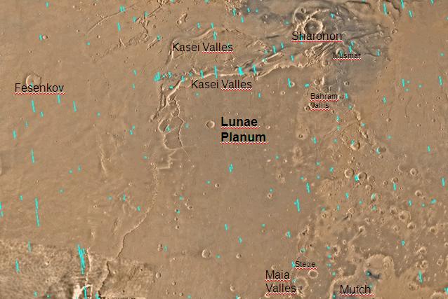
English: Map of Lunae Palus quadrangle with labels. The small, colored rectangles represent image footprints for the narrow angle camera on the Mars Global Surveyor. Some are about 1 mile wide, the otheers are about 2 miles wide. Português: Mapa do quadrângulo de Lunae Plus, em Marte |
| 日期 | |
| 来源 | http://www.msss.com/moc_gallery/s05_s10/mc10.html |
| 作者 | The map was made by the U.S. Geological survey for NASA. Jim Secosky (Jimmarsmars at en.wikipedia) modified. |
许可协议
| Public domainPublic domainfalsefalse |
| 本文件完全由NASA创作,在美国属于公有领域。根据NASA的版权方针,NASA的材料除非另有声明否则不受版权保护。(参见Template:PD-USGov/zh、NASA版权方针页面或JPL图片使用方针。) | ||
 |
警告:
|
原始上传日志
The original description page was here. All following user names refer to en.wikipedia.
- 2008-12-29 19:57 Jimmarsmars 638×427× (48204 bytes) {{Information |Description=Map of Lunae Palus map with labels |Source=http://www.msss.com/moc_gallery/s05_s10/mc10.html |Date=December 29, 2008 |Author=Jim Secosky modified NASA map. |Permission= |other_versions= }}
说明
添加一行文字以描述该文件所表现的内容
此文件中描述的项目
描绘内容
29 12 2008
文件历史
点击某个日期/时间查看对应时刻的文件。
| 日期/时间 | 缩略图 | 大小 | 用户 | 备注 | |
|---|---|---|---|---|---|
| 当前 | 2011年1月21日 (五) 14:52 | | 638 × 427(47 KB) | Romullo | {{Information |Description= Mapa do quadrângulo de Lunae Plus, em Marte |Source= Wiki:en |Date=21/01/11 |Author=NASA |Permission= |other_versions=http://upload.wikimedia.org/wikipedia/en/2/29/Lunae_Palus_map.JPG }} |
文件用途
全域文件用途
以下其他wiki使用此文件:
- en.wikipedia.org上的用途
- es.wikipedia.org上的用途
- hi.wikipedia.org上的用途
- ja.wikipedia.org上的用途
- ml.wikipedia.org上的用途
- pt.wikipedia.org上的用途
- ru.wikipedia.org上的用途
- tr.wikipedia.org上的用途
- uk.wikipedia.org上的用途
元数据
此文件中包含有扩展的信息。这些信息可能是由数码相机或扫描仪在创建或数字化过程中所添加。
如果此文件的源文件已经被修改,一些信息在修改后的文件中将不能完全反映出来。
| _error | 0 |
|---|