File:ESI_map.png
维基百科,自由的 encyclopedia
此为最大尺寸。
ESI_map.png (270 × 319像素,文件大小:56 KB,MIME类型:image/png)

|
此transport map图片可使用矢量图形重新创建为SVG文件。这具有很多好处;更多信息请参见共享资源:待清理媒体。如果存在此图片的SVG格式,请将其上传,然后将此模板替换为
{{vector version available|新图片名称}}。
建议您将SVG命名为“ESI map.svg”,这样在使用Vector version available(或Vva)模板时就不需要填写新图片名称参数。 |
| Datasource (reference to visualized facts) is not provided for the data that is visualized in this self-made work. |
摘要
| 描述ESI map.png |
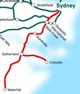
This is a map of the Eastern Suburbs & Illawarra Line in Sydney, Australia, traced on this public domain map. Original edit by NE2 |
| 日期 | 2007年1月24日 (原始上传日期) |
| 来源 | 无法识别来源。根据版权声明推断为其自己的作品。 |
| 作者 | 无法识别作者。根据版权声明推断作者为NE2。 |
许可协议
| Public domainPublic domainfalsefalse |
| 我,本作品著作权人,释出本作品至公有领域。这适用于全世界。 在一些国家这可能不合法;如果是这样的话,那么: 我无条件地授予任何人以任何目的使用本作品的权利,除非这些条件是法律规定所必需的。 |
说明
添加一行文字以描述该文件所表现的内容
此文件中描述的项目
描绘内容
受版权保护,并由版权所有者释出于公有领域 简体中文(已转写)
著作权持有者释出至公有领域 简体中文(已转写)
24 1 2007
文件历史
点击某个日期/时间查看对应时刻的文件。
| 日期/时间 | 缩略图 | 大小 | 用户 | 备注 | |
|---|---|---|---|---|---|
| 当前 | 2007年8月11日 (六) 11:16 | | 270 × 319(56 KB) | Vicer | This is a map of the Eastern Suburbs & Illawarra Line in Sydney, Australia, traced on this public domain map. Original edit by NE2. |
| 2007年1月24日 (三) 17:25 |  | 278 × 334(59 KB) | NE2 | Cropped. | |
| 2007年1月24日 (三) 17:22 |  | 850 × 850(162 KB) | NE2 | This is a map of the Eastern Suburbs & Illawarra Line in Sydney, Australia, traced on this public domain map. Category:maps |
文件用途
以下8个页面使用本文件:
全域文件用途
以下其他wiki使用此文件:
- en.wikipedia.org上的用途