File:Dissolution_of_Austria-Hungary.png
维基百科,自由的 encyclopedia
本预览的尺寸:800 × 473像素。 其他分辨率:320 × 189像素 | 640 × 378像素 | 1,024 × 605像素 | 1,641 × 970像素。
原始文件 (1,641 × 970像素,文件大小:182 KB,MIME类型:image/png)

|
此map图片可使用矢量图形重新创建为SVG文件。这具有很多好处;更多信息请参见共享资源:待清理媒体。如果存在此图片的SVG格式,请将其上传,然后将此模板替换为
{{vector version available|新图片名称}}。
建议您将SVG命名为“Dissolution of Austria-Hungary.svg”,这样在使用Vector version available(或Vva)模板时就不需要填写新图片名称参数。 |
| 描述Dissolution of Austria-Hungary.png |
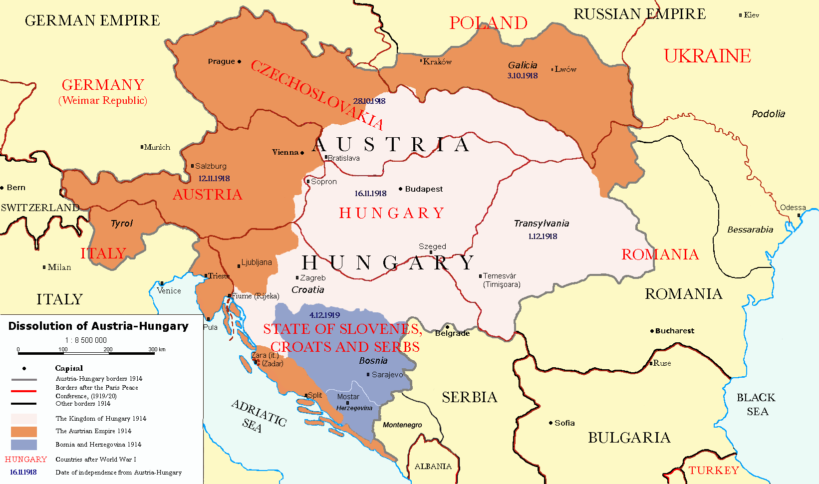
Čeština: Rozdělení Rakouska-Uherska po první světové válce, podle Pařížských předměstských smluv (Versailles s Německem, Saint-Germain-en-Laye s Rakouskem, Neuilly-sur-Seine s Bulharskem, Trianon s Maďarskem, Sèvres s Tureckem), dojednaných na Pařížské mírové konferenci (1919). Deutsch: Das Ende Österreich-Ungarns nach den Pariser Vorortverträgen. English: The end of Austria-Hungary after the Paris Treaty. |
| 日期 | (UTC) |
| 来源 | |
| 作者 |
|
| 其他版本 | العربيَّة |
| 这是一张修改过的图片,这意味着它已在原版本的基础上通过软件进行了编辑,改动内容:translated to english。其原始版本为:Österreich-Ungarns Ende.png。修改者:P. S. Burton。
|
我,本作品著作权人,特此采用以下许可协议发表本作品:
| 本文件采用知识共享署名-相同方式共享 3.0 未本地化版本许可协议授权。 | ||
| ||
| 本许可协议标签作为GFDL许可协议更新的组成部分被添加至本文件。http://creativecommons.org/licenses/by-sa/3.0/CC BY-SA 3.0Creative Commons Attribution-Share Alike 3.0truetrue |

|
已授权您依据自由软件基金会发行的无固定段落及封面封底文字(Invariant Sections, Front-Cover Texts, and Back-Cover Texts)的GNU自由文件许可协议1.2版或任意后续版本的条款,复制、传播和/或修改本文件。该协议的副本请见“GNU Free Documentation License”。http://www.gnu.org/copyleft/fdl.htmlGFDLGNU Free Documentation Licensetruetrue |
您可以选择您需要的许可协议。
原始上传日志
This image is a derivative work of the following images:
- File:Österreich-Ungarns_Ende.png licensed with Cc-by-sa-3.0-migrated, GFDL
- 2007-07-16T11:59:46Z Nihad Hamzic 1568x970 (81916 Bytes) The original image seems to had been saved as JPEG, and that some previous uploader had simply directly converted it to PNG. I have greatly optimised its size by removing JPEG artifacts, reducing color domain, etc.
- 2006-01-23T20:47:06Z AlphaCentauri 1568x970 (924912 Bytes) kleine Änderungen
- 2005-09-23T14:27:32Z AlphaCentauri 1568x970 (924912 Bytes) Laibach and Triest
- 2005-09-17T03:29:55Z Berkut 1568x970 (355556 Bytes) better file compression
- 2005-09-16T09:39:55Z Kallgan 1568x970 (438065 Bytes) Das Ende Österreich-Ungarns nach dem Pariser Vorortverträgen. Selbsterstellte Karte. {{Bild-GFDL}} (Borders between Romania and Bulgaria in Dobrogea modified)(Source: Goode's World Atlas, Rand McNally & Company, 1932 & 19
- 2005-07-04T13:39:25Z AlphaCentauri 1568x970 (924912 Bytes) verbessert
- 2005-04-28T19:29:14Z AlphaCentauri 1568x970 (924912 Bytes) so, nochmals verbessert
- 2005-04-12T18:45:25Z AlphaCentauri 1568x970 (924912 Bytes) nochmals verbessert
- 2005-04-12T15:06:42Z AlphaCentauri 1568x970 (924912 Bytes)
- 2005-04-12T14:47:08Z AlphaCentauri 1568x970 (924912 Bytes) verbesserte Version
- 2005-01-05T20:59:50Z AlphaCentauri 1568x970 (924912 Bytes) verbesserte Version
- 2004-12-29T10:14:48Z AlphaCentauri 1568x970 (924912 Bytes) Das Ende Österreich-Ungarns (Karte)
Uploaded with derivativeFX
说明
添加一行文字以描述该文件所表现的内容
GNU自由文档许可证1.2或更高版本 简体中文(已转写)
知识共享署名-相同方式共享3.0未本地化版本 简体中文(已转写)
23 11 2010
1914
image/png
文件历史
点击某个日期/时间查看对应时刻的文件。
| 日期/时间 | 缩略图 | 大小 | 用户 | 备注 | |
|---|---|---|---|---|---|
| 当前 | 2021年12月26日 (日) 17:57 | | 1,641 × 970(182 KB) | Claude Zygiel | Cosmetic and correct romanian-ukrainian border since April 9, 1918 |
| 2020年12月6日 (日) 16:27 |  | 1,568 × 970(175 KB) | Crash48 | before 1919, the Greek-Bulgarian border was far to the southwest | |
| 2020年12月3日 (四) 18:08 |  | 1,568 × 970(175 KB) | Crash48 | Lwów didn't become Lviv until 1939 | |
| 2020年12月2日 (三) 16:37 |  | 1,568 × 970(148 KB) | Crash48 | Romanian-Ukrainian border was way off; fixed according to File:Romania1901.JPG | |
| 2020年3月10日 (二) 15:20 |  | 1,568 × 970(229 KB) | Kufl | Odessa was never part of the Romania at that time | |
| 2013年10月10日 (四) 15:58 |  | 1,568 × 970(163 KB) | Lvivske | Incorrectly states that Ukraine was the Russian SFSR (Russia is not seen on the map), the area of Ukraine was the Ukraine post-WW1 and later following another war, the Ukrainian Soviet Socialist Republic, and joined ... | |
| 2010年11月24日 (三) 21:36 |  | 1,568 × 970(164 KB) | P. S. Burton | Ungarn ->Hungary etc. | |
| 2010年11月23日 (二) 21:46 |  | 1,568 × 970(163 KB) | P. S. Burton | Zara -> Zara (Zadar) | |
| 2010年11月23日 (二) 21:41 |  | 1,568 × 970(163 KB) | P. S. Burton | Black Sea ->BLACK SEA | |
| 2010年11月23日 (二) 21:39 |  | 1,568 × 970(163 KB) | P. S. Burton | {{Information |Description={{cs|Rozdělení Rakouska-Uherska po první světové válce, podle Pařížských předměstských smluv ([[:cs:Versailles|Ver |
文件用途
以下3个页面使用本文件:
全域文件用途
以下其他wiki使用此文件:
- ar.wikipedia.org上的用途
- azb.wikipedia.org上的用途
- ba.wikipedia.org上的用途
- ca.wikipedia.org上的用途
- de.wikipedia.org上的用途
- el.wikipedia.org上的用途
- en.wikipedia.org上的用途
- Austria-Hungary
- Nation state
- Dalmatia
- Aftermath of World War I
- Treaty of Saint-Germain-en-Laye (1919)
- World War I
- Anschluss
- Key events of the 20th century
- Wikipedia:Graphics Lab/Map workshop/Archive/Dec 2010
- Green Cadres
- Dissolution of Austria-Hungary
- Austria victim theory
- User:Lord Milner/Lord Milner Timeline
- User:Lord Milner/sandbox/Lord Milner's Life Timeline
- Draft:Timeline of Alfred Milner
- User:Falcaorib/Austria-Hungary
- fr.wikipedia.org上的用途
- he.wikipedia.org上的用途
- hr.wikipedia.org上的用途
- hy.wikipedia.org上的用途
- id.wikipedia.org上的用途
- io.wikipedia.org上的用途
- it.wikipedia.org上的用途
- lmo.wikipedia.org上的用途
- lt.wikipedia.org上的用途
- no.wikipedia.org上的用途
- pnb.wikipedia.org上的用途
- pt.wikipedia.org上的用途
- ro.wikipedia.org上的用途
- sh.wikipedia.org上的用途
- sv.wikipedia.org上的用途
- ta.wikipedia.org上的用途
查看此文件的更多全域用途。
元数据
此文件中包含有扩展的信息。这些信息可能是由数码相机或扫描仪在创建或数字化过程中所添加。
如果此文件的源文件已经被修改,一些信息在修改后的文件中将不能完全反映出来。
| 水平分辨率 | 37.8 dpc |
|---|---|
| 垂直分辨率 | 37.8 dpc |