File:Sunda_strait_map_v4.png
维基百科,自由的 encyclopedia
此为最大尺寸。
Sunda_strait_map_v4.png (487 × 351像素,文件大小:176 KB,MIME类型:image/png)
摘要
| 描述Sunda strait map v4.png |
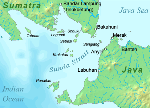
Deutsch: Karte der Sundastraße, Indonesien
English: Map of the Sunda Strait, Indonesia |
||||||
| 日期 | |||||||
| 来源 | 自己的作品 | ||||||
| 作者 | Telim tor | ||||||
| 授权 (二次使用本文件) |
|
||||||
| 其他版本 |
|

说明
添加一行文字以描述该文件所表现的内容
此文件中描述的项目
描绘内容
受版权保护,并由版权所有者释出于公有领域 简体中文(已转写)
著作权持有者释出至公有领域 简体中文(已转写)
23 1 2011
文件历史
点击某个日期/时间查看对应时刻的文件。
| 日期/时间 | 缩略图 | 大小 | 用户 | 备注 | |
|---|---|---|---|---|---|
| 当前 | 2011年1月23日 (日) 11:37 | | 487 × 351(176 KB) | Telim tor | == {{int:filedesc}} == {{Information |Description={{en|Map of the Sunda Strait, Indonesia}} |Source={{own}} |Date=2011-01-23 |Author=Telim tor |Permission={{PD-Demis}} |other_versions=={{Extracted from|Sunda_strait_map_v3.png}} }} [[Ca |
文件用途
没有页面使用本文件。
全域文件用途
以下其他wiki使用此文件:
- ar.wikipedia.org上的用途
- de.wikipedia.org上的用途
- en.wikipedia.org上的用途
- id.wikipedia.org上的用途
- it.wikipedia.org上的用途
- ka.wikipedia.org上的用途
- nl.wikipedia.org上的用途
- no.wikipedia.org上的用途
- sh.wikipedia.org上的用途
- uk.wikipedia.org上的用途
- zh-yue.wikipedia.org上的用途