File:Adams_onis_map.png
维基百科,自由的 encyclopedia
本预览的尺寸:733 × 599像素。 其他分辨率:294 × 240像素 | 587 × 480像素。
原始文件 (800 × 654像素,文件大小:226 KB,MIME类型:image/png)

|
File:Adams-Onís treaty map-en.svg是此文件的矢量版本。 如果此文件质量不低于原点阵图,就应该将这个PNG格式文件替换为此文件。
File:Adams onis map.png → File:Adams-Onís treaty map-en.svg
更多信息请参阅Help:SVG/zh。
|
 |
摘要
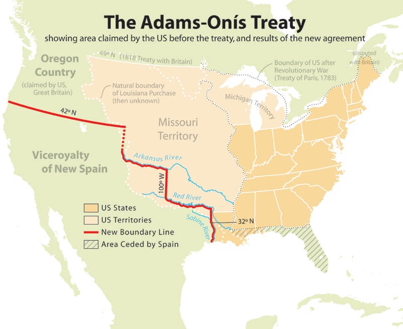
English: Map showing the results of the Adams-Onís Treaty of 1819.
Please state the map from which this was traced, or the other cartographic sources that provided the information allowing you to create the boundaries show.[citation needed]
en:User:Citynoise is the creator at stated at source: I, Citynoise, am the creator of this map and hereby release it per the ShareAlike Attribution license. See www.radicalcartography.net for more.
许可协议
本文件采用知识共享署名-相同方式共享 2.5 通用许可协议授权。
- 您可以自由地:
- 共享 – 复制、发行并传播本作品
- 修改 – 改编作品
- 惟须遵守下列条件:
- 署名 – 您必须对作品进行署名,提供授权条款的链接,并说明是否对原始内容进行了更改。您可以用任何合理的方式来署名,但不得以任何方式表明许可人认可您或您的使用。
- 相同方式共享 – 如果您再混合、转换或者基于本作品进行创作,您必须以与原先许可协议相同或相兼容的许可协议分发您贡献的作品。
说明
添加一行文字以描述该文件所表现的内容
A map showing the results of the Adams-Onis treaty, featuring the land exchanged with Spain
此文件中描述的项目
描绘内容
知识共享署名-相同方式共享2.5通用 简体中文(已转写)
image/png
数据大小 简体中文(已转写)
231,585 字节
654 像素
800 像素
文件历史
点击某个日期/时间查看对应时刻的文件。
| 日期/时间 | 缩略图 | 大小 | 用户 | 备注 | |
|---|---|---|---|---|---|
| 当前 | 2012年7月18日 (三) 18:56 | | 800 × 654(226 KB) | Kmusser | rm Russian claim to Oregon (was dropped by the timeframe of this map - see Adams-Onis talk page) |
| 2006年7月10日 (一) 19:42 |  | 800 × 654(227 KB) | JMPerez~commonswiki | == Summary == Map showing the results of the Adams-Onís Treaty of 1819. I, Citynoise, am the creator of this map and hereby release it per the ShareAlike Attribution license. See www.radicalcartography.net for more. From English Wikipedia. == Licensin |
文件用途
以下页面使用本文件:
全域文件用途
以下其他wiki使用此文件:
- ar.wikipedia.org上的用途
- ca.wikipedia.org上的用途
- cs.wikipedia.org上的用途
- da.wikipedia.org上的用途
- de.wikipedia.org上的用途
- en.wikipedia.org上的用途
- John Quincy Adams
- James Monroe
- Adams–Onís Treaty
- Moses Austin
- Spanish Canadians
- Spanish Texas
- Presidency of James Monroe
- User:Esemono/British
- Territorial evolution of the Caribbean
- List of territorial claims and designations in Colorado
- Early history of the Arkansas Valley in Colorado
- History of U.S. foreign policy, 1801–1829
- Long's Expedition of 1820
- User:Falcaorib/Canada, United States and Mexico
- eu.wikipedia.org上的用途
- fa.wikipedia.org上的用途
- fi.wikipedia.org上的用途
- he.wikipedia.org上的用途
- hu.wikipedia.org上的用途
- id.wikipedia.org上的用途
- it.wikipedia.org上的用途
- ja.wikipedia.org上的用途
- ko.wikipedia.org上的用途
- nl.wikipedia.org上的用途
- no.wikipedia.org上的用途
- pl.wikipedia.org上的用途
- pnb.wikipedia.org上的用途
- pt.wikipedia.org上的用途
- ro.wikipedia.org上的用途
- ru.wikipedia.org上的用途
- simple.wikipedia.org上的用途
- sr.wikipedia.org上的用途
- sv.wikipedia.org上的用途
- th.wikipedia.org上的用途
- uk.wikipedia.org上的用途
- ur.wikipedia.org上的用途
查看此文件的更多全域用途。
元数据
此文件中包含有扩展的信息。这些信息可能是由数码相机或扫描仪在创建或数字化过程中所添加。
如果此文件的源文件已经被修改,一些信息在修改后的文件中将不能完全反映出来。
| 水平分辨率 | 28.35 dpc |
|---|---|
| 垂直分辨率 | 28.35 dpc |