布里恩茨红峰
来自维基百科,自由的百科全书

布里恩茨红峰(德语:Brienzer Rothorn,意即为“布里恩茨的红色山峰”)是瑞士的山峰,位于该国中北部,横跨卢塞恩州、上瓦尔登州和伯尔尼州,属于埃默河谷山的一部分,海拔高度2,350米,山体由石灰岩组成。

图片
-
 Steam train (Brienzer Rothorn Bahn) on the Planalp near Mittler Stafel
 -
 Approaching the summit near Ober Stafel
 -
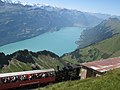 View of Lake Brienz and Interlaken in the background
 -
 The summit station over the clouds ("sea of fog") during a day in August


参考资料
Wikiwand in your browser!
Seamless Wikipedia browsing. On steroids.
Every time you click a link to Wikipedia, Wiktionary or Wikiquote in your browser's search results, it will show the modern Wikiwand interface.
Wikiwand extension is a five stars, simple, with minimum permission required to keep your browsing private, safe and transparent.