File:OttomanEmpireIn1683tr.png
From Wikipedia, the free encyclopedia
全幅 (微格一九六六矩一八五〇,度:三二七 KB,多用網際網路副檔名之型:image/png)
此檔為維基共享資源之共傳,可另策用也。 於共庫上檔述之示。
概
| 述OttomanEmpireIn1683tr.png |
English: Map depicting the Ottoman Empire at its greatest extent, in 1683.
Türkçe: 1683 yılına gelindiğinde Osmanlı İmparatorluğu haritası |
| 期 | |
| 碼 | Self drawn, mainly based on Robert Mantran (ed.), Histoire de l'Empire Ottoman, Paris: Fayard (1989), also en:List of Ottoman Empire dominated territories, Image:Ottoman 1683.png, [1], and [2]. Background map modified from Image:A large blank world map with oceans marked in blue.svg. |
| 作者 | Atilim Gunes Baydin yapımı, Osmanlı98 Türkçeye çevirdi. |
| 其他版本 |
[纂]
|


權
| Public domainPublic domainfalsefalse |
| 我,此作品的版權所有人,釋出此作品至公共領域。此授權條款在全世界均適用。 這可能在某些國家不合法,如果是的話: 我授予任何人有權利使用此作品於任何用途,除受法律約束外,不受任何限制。 |
說明
添加單行說明來描述出檔案所代表的內容
在此檔案描寫的項目
描繪內容 繁體中文
著作權狀態 繁體中文
保有知識產權並由其所有者公開於公有領域 繁體中文
授權條款 繁體中文
著作權持有者釋出至公有領域 繁體中文
成立或建立時間 繁體中文
七 二 2010
檔誌
揀日尋檔。
| 日時 | 縮 | 度 | 用戶 | 註 | |
|---|---|---|---|---|---|
| 今 | 二〇一六年一一月一四日 (一) 二二時一五分 | 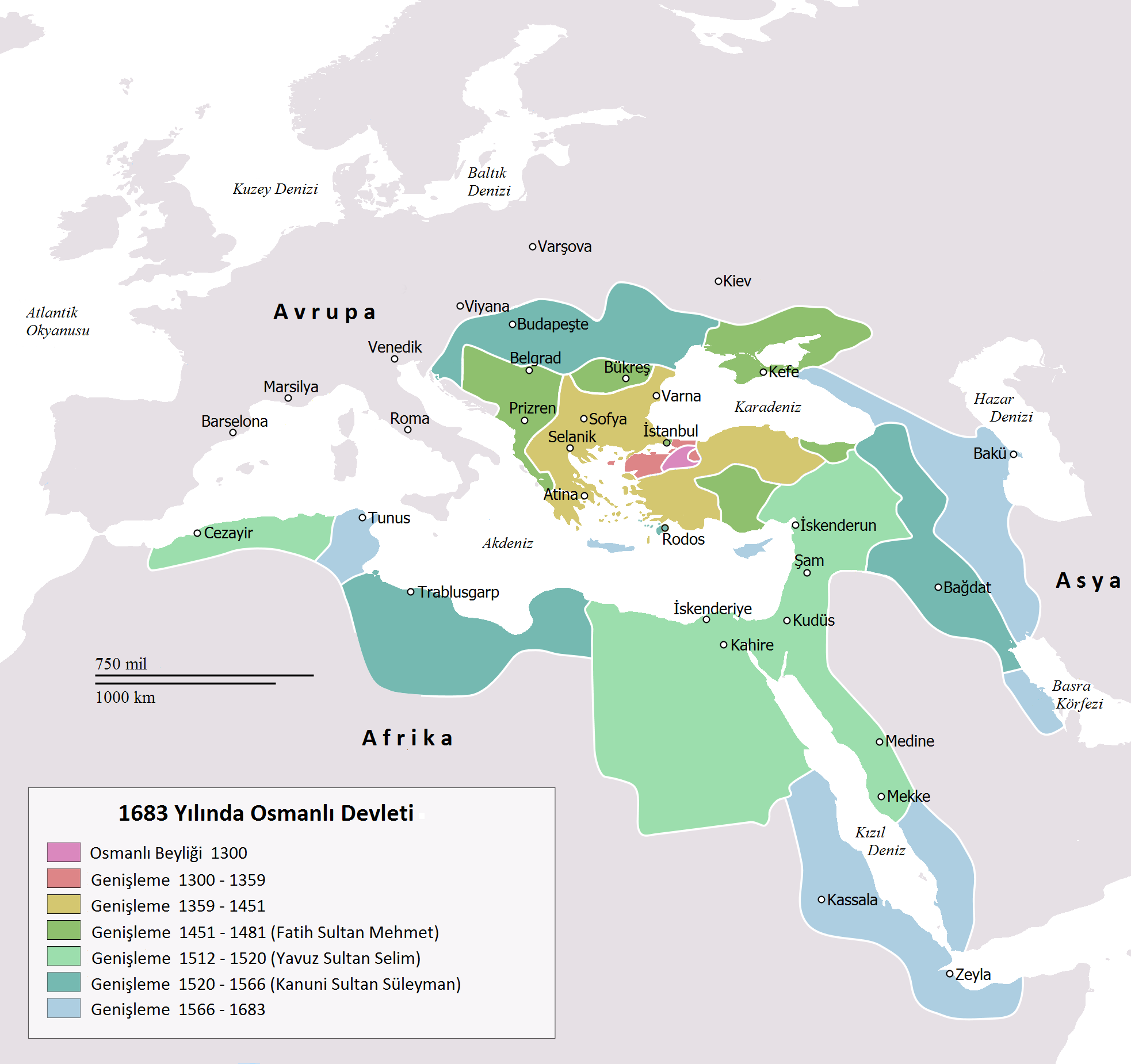 | 一九六六矩一八五〇(三二七 KB) | Gündoğdu | New version.High image quality |
| 二〇一〇年二月二八日 (日) 一六時二三分 |  | 六三七矩五九九(一〇一 KB) | Osmanlı98 | Cezayir=Trablus | |
| 二〇一〇年二月七日 (日) 一三時〇四分 |  | 六三七矩五九九(一〇〇 KB) | Osmanlı98 | {{Information |Description={{en|1=Map depicting the Ottoman Empire at its greatest extent, in 1683.}} {{tr|1=1683 yılına gelindiğinde Osmanlı İmparatorluğu haritası}} |Source=Self drawn, mainly based on ''Robert Mantran (ed.), Histoire de l'Empire |
檔所繫者
無頁連本檔也。
總文之用
下他共筆連本檔:
- az.wikipedia.org上之用
- tr.wikipedia.org上之用
- ug.wikipedia.org上之用
補註
此檔補註,製者所添,如相機、掃描之器;後若更檔,補註不誠也。
| 水平解析度 | 三七點八 dpc |
|---|---|
| 垂直解析度 | 三七點八 dpc |