File:China-Inner-Mongolia.png
From Wikipedia, the free encyclopedia
无更高分辨率可提供。
China-Inner-Mongolia.png (268×218像素,文件大小:15 KB,MIME类型:image/png)
箇文件维基共享资源里个,作兴会畀别个项目使用。渠个描述页里个说明显示如下。
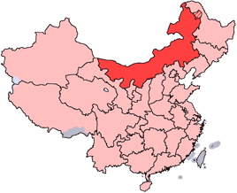
en: Location of Inner Mongolia Autonomous Region in the People's Republic of China. See Locator maps of province-level divisions of the People's Republic of China for more information. The striped area is nominally part of Inner Mongolia, but it is administered by Daxing'anling Prefecture of Heilongjiang Province.
zh: 内蒙古自治區在中華人民共和國的位置。另見Locator maps of province-level divisions of the People's Republic of China。加斜杠的地區由黑龍江省大興安嶺地區所管轄,僅在名義上為内蒙古的一部分。

|
已授权复制、传播搭/或修改本文档,依据自由软件基金会发布个GNU自由文档许可证1.2版或任何后续版本个条款;呒不弗可变章节,也呒不封面封底文字。许可证个副本包括勒GNU Free Documentation License章节当中。http://www.gnu.org/copyleft/fdl.htmlGFDLGNU Free Documentation Licensetruetrue |
| 本文件用知识共享“署名-相同方式共享 3.0 未本地化版本”许可协议授权。 | ||
| ||
| 本许可协议标签作为GFDL许可协议更新的组成部分被添加至本文件。http://creativecommons.org/licenses/by-sa/3.0/CC BY-SA 3.0Creative Commons Attribution-Share Alike 3.0truetrue |
说明
添加一行文字以描述该文件所表现的内容
此文件中描述的项目
描绘内容 简体中文
许可协议 简体中文
GNU自由文档许可证1.2或更高版本 简体中文
媒体类型 简体中文
image/png
数据大小 简体中文
15,782 字节
高度 简体中文
218 像素
宽度 简体中文
268 像素
文件历史
揿一个日脚/辰光来望当时出现过个文件。
| 日脚 / 辰光 | 微缩图 | 维度 | 用户 | 备注 | |
|---|---|---|---|---|---|
| 当前 | 2005年7月15号 (五) 22:44 | | 268 × 218(15 KB) | Schaengel89~commonswiki | transparent background |
| 2005年6月5号 (日) 05:42 |  | 268 × 218(9 KB) | Ran | '''en''': Location of Inner Mongolia in the People's Republic of China. See Category:Locator maps of province-level divisions of the People's Republic of China for more information. '''zh''': 内蒙古自治區在中華人民共和國的位置。另 |
文件用法
下向许1张用着箇文件:
全域文件用场
下底个其他wiki使用箇只文件:
- da.wikipedia.org上个用途
- de.wikipedia.org上个用途
- en.wikipedia.org上个用途
- Wikipedia:WikiProject Chinese provinces/Locator maps
- Fengzhen
- Yin Mountains
- Hanggai (village)
- Tengger Desert
- Liaobei
- Dolon Nor
- Oroqen Autonomous Banner
- Solun, Horqin Right Front Banner
- Bailingmiao
- Dongsheng District
- Chifeng Yulong Airport
- Hulunbuir Hailar Airport
- Tongliao Airport
- Xilinhot Airport
- Template:InnerMongolia-geo-stub
- Lang Mountains
- Tsondol
- Xar Moron River
- Honggor Sum, Siziwang Banner
- Baochang, Taibus Banner
- Hobor
- Honggor Sum, Sonid Left Banner
- Hongort
- Shangdu County
- Xuejiawan, Jungar Banner
- Dashuigou Formation
- Bayin-Gobi Formation
- Jalaid Banner
- Hexigten Banner
- Horinger County
- Xincheng, Hohhot
- Wuyuan County, Inner Mongolia
- Dengkou County
查看本文件个更多全域用途。