File:Black_Sea_map-sv.png
From Wikipedia, the free encyclopedia
Kadako hin nga pahiuna nga pagawas: 786 × 599 nga mga pixel. Iba nga mga resolusyon: 315 × 240 nga mga pixel | 630 × 480 nga mga pixel | 1,007 × 768 nga mga pixel | 1,200 × 915 nga mga pixel.
Orihinal nga paypay (1,200 × 915 nga pixel, kadako han fayl: 315 nga KB, MIME nga tipo: image/png)
An fayl in tikang ha Wikimedia Commons ngan puydi mahigamitan para han iba nga mga proyekto. An paglaladawan han iya fayl han paglaladawan nga pakli didto in ginpapakita ha sirong.
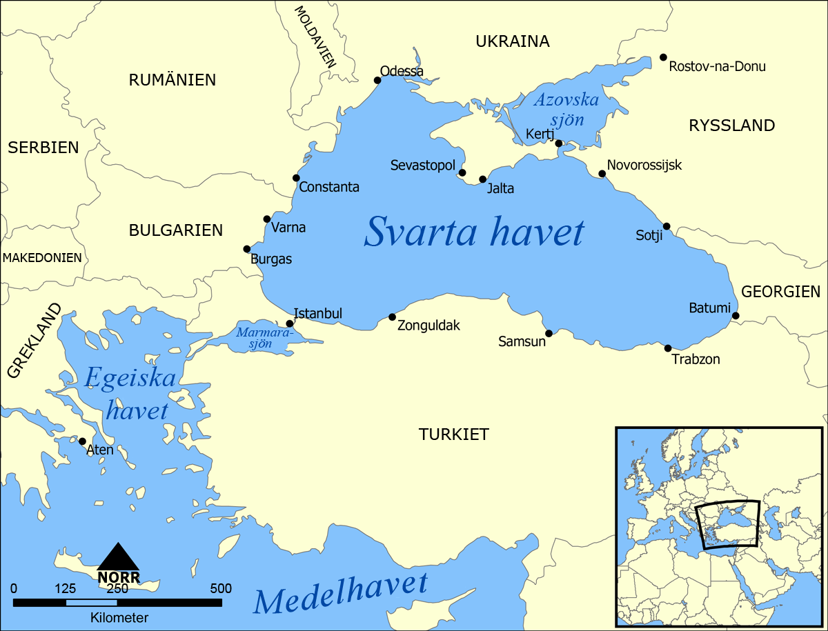
| TigtulidongBlack Sea map-sv.png | A map showing the location of the Black Sea and some of the large or prominent ports around it. The Sea of Azov and Sea of Marmara are also labelled. |
| Petsa | (UTC) |
| Ginkuhaan | |
| Awtor |
|
| Other versions |
[igliwat]
|


.png)


| This is a retouched picture, which means that it has been digitally altered from its original version. The original can be viewed here: Black Sea map.png:
|
I, the copyright holder of this work, hereby publish it under the following licenses:
| Ini nga file in nakalisensya ha ilarom han Creative Commons Attribution-Share Alike 3.0 Unported license. | ||
| ||
| This licensing tag was added to this file as part of the GFDL licensing update.http://creativecommons.org/licenses/by-sa/3.0/CC BY-SA 3.0Creative Commons Attribution-Share Alike 3.0truetrue |

|
An permiso in ginhatag ha pagkopya, pagpakalat ngan/o pagliwat hinin nga dokumento ha ilarom han mga termino han GNU Free Documentation License, Version 1.2 o mas uruurhi nga version nga ginmantala han Free Software Foundation; nga may-ada waray Invariant Sections, waray Front-Cover Texts, ngan waray Back-Cover Texts. May-ada kopya hin lisensya nga ginlalakip ha seksyon nga may-ada pamagat nga GNU Free Documentation License.http://www.gnu.org/copyleft/fdl.htmlGFDLGNU Free Documentation Licensetruetrue |
Puydi ka pumili hin lisenysa nga karuyag mo.
Original upload log
This image is a derivative work of the following images:
- File:Black_Sea_map.png licensed with Cc-by-sa-3.0-migrated, GFDL
- 2007-07-10T18:10:36Z NormanEinstein 1200x915 (382990 Bytes) Updated maps to add Russian city of Sochi.
- 2007-05-07T19:11:11Z NormanEinstein 1200x912 (378400 Bytes) Corrected city name typo.
- 2006-05-29T13:10:42Z NormanEinstein 1200x914 (136455 Bytes) Reduced image size.
- 2005-07-25T14:54:05Z NormanEinstein 1200x916 (487643 Bytes) A map showing the location of the Black Sea and some of the large or prominent ports around it. The Sea of Azov and Sea of Maramara are also labelled. Created by NormanEinstein, July 25, 2005. {{GFDL-self}} [[Category:Maps
Uploaded with derivativeFX
Captions
Add a one-line explanation of what this file represents
Items portrayed in this file
depicts English
copyright status English
copyrighted English
media type English
image/png
checksum English
cb3a0346d98e696f9b90db4ad6139c72228fde36
data size English
322,217 Byte
height English
915 pixel
width English
1,200 pixel
Kaagi han paypay
Pidlita an adlaw/oras para makit-an an fayl nga naggawas hito nga oras.
| Pitsa/Oras | Thumbnail | Mga dimensyon | Gumaramit | Komento | |
|---|---|---|---|---|---|
| waray pa kasasapawi | 18:22, 21 Abril 2010 | | 1,200 × 915 (315 nga KB) | Inteloutside2 | {{Information |Description=A map showing the location of the Black Sea and some of the large or prominent ports around it. The Sea of Azov and Sea of Marmara are also labelled. |Source=*File:Black_Sea_map.png |Date=2010-04-21 18:22 (UTC) |Author=*[[ |
Mga Sumpay
Waray pakli nga nagamit hinin nga file.
Global file usage
An masunod nga iba nga mga wiki in nagamit hini nga file:
- Paggamit ha ka.wiktionary.org
- Paggamit ha sv.wikipedia.org
Ginkuha tikang ha "https://war.wikipedia.org/wiki/Paypay:Black_Sea_map-sv.png"