File:Colonisation_1885.png
From Wikipedia, the free encyclopedia
File orixenałe (1 200 × 526 pixel, dimension del file: 206 KB, tipo MIME: image/png)
Sto file el vien da Wikimedia Commons e se połe dopararlo in altri projeti. Sto cuà vien mostrà ła descrision prexente in te ła pajina de descrision del file.
| References for this description (or part of this) or for the depiction in the file are not provided. |
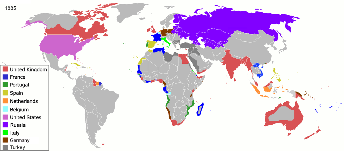
| DescrisionColonisation 1885.png |
Map of major world powers by year, derived from public domain animated map on wikipedia.
As the orriginal licence of the animation was Public Domain, this image which has been derived from it is too:
|
|||||||||||||||||||
| Data | ||||||||||||||||||||
| Provenjiensa | public domain animated map by ArdadN here | |||||||||||||||||||
| Autore | ArdadN | |||||||||||||||||||
.jpg)
._LOC_2001620596.jpg)

|
Questa immagine (categorizzazione automatica: historical map) o tutte le immagini in questa categoria o galleria dovrebbero essere ricreate usando grafica vettoriale come file SVG. Questo offre diversi vantaggi: vedi Commons:Media for cleanup per maggiori informazioni. Se è disponibile una versione in formato SVG di questa immagine, per favore caricala. Dopo aver caricato un file SVG, sostituisci questo avviso con il template {{Vector version available|nome_immagine.svg}}.
|
Didascalie
Elementi ritratti in questo file
raprezenta a
22 mar 2007
image/png
checksum italian
831fd10c262a996a3291205f48ebb3278f0cca4d
dimensione dati italian
210 626 byte
526 pixel
1 200 pixel
Istoria del file
Schicia so on grupo data/or pa vedare el file come che el se presentava in tel momento indegà.
| Data/Ora | Miniadura | Dimension | Utente | Comento | |
|---|---|---|---|---|---|
| In ultima | 11:05, 8 nov 2021 | | 1 200 × 526 (206 KB) | Randomastwritter | jubaland |
| 11:52, 5 avr 2020 |  | 1 200 × 526 (206 KB) | Ориенталист | South Sakhalin was part of Russia in 1885 | |
| 13:17, 2 maj 2015 |  | 1 425 × 625 (49 KB) | Chrischerf | German Empire and colonies in 1885; Sudan under control of the Mahdi | |
| 04:57, 3 ago 2014 |  | 1 425 × 625 (54 KB) | Alvin Lee | correcting the boundaries of Russia and China | |
| 15:54, 3 nov 2013 |  | 1 425 × 625 (78 KB) | McZusatz | Reverted to version as of 00:22, 24 January 2011 [corrupt file?] | |
| 17:24, 3 nov 2012 |  | 1 425 × 625 (67 KB) | Franco310397 | Spanish presence in Micronesia (Oceania) included in the Captaincy General of the Philippines. In the Caroline Islands and the Mariana Islands. | |
| 02:22, 24 zen 2011 |  | 1 425 × 625 (78 KB) | Micsha~commonswiki | Reverted to version as of 02:17, 3 May 2010 | |
| 02:22, 24 zen 2011 |  | 506 × 326 (85 KB) | Micsha~commonswiki | Only Africa; includes map key | |
| 04:17, 3 maj 2010 |  | 1 425 × 625 (78 KB) | Kieran4 | slight edit | |
| 04:14, 3 maj 2010 |  | 1 425 × 625 (78 KB) | Kieran4 | Correct Dutch East INdies |
Doparasion del file
Nisuna pajina ła dopara sto file
Doparasion globałe del file
St'altre wiki cua le dopara sto file:
- Uxo de am.wikipedia.org inte le pàjine
- Uxo de de.wikipedia.org inte le pàjine
- Uxo de en.wikipedia.org inte le pàjine
- Uxo de es.wikipedia.org inte le pàjine
- Uxo de fr.wikipedia.org inte le pàjine
- Uxo de he.wikipedia.org inte le pàjine
- Uxo de oc.wikipedia.org inte le pàjine
- Uxo de sk.wikipedia.org inte le pàjine
Metadati
Sto file el detien informasion xontive, probabiłe che łe sia stae xontae da ła fotocamara o da el scanner doparà par farlo o dijitałixarlo. Se el file el xé sta modifegà dal so stato orixenałe, alguni detaji i podaria esare ndar perdesti.
| Rexołusion orixontałe | 47,24 punti par çentimetro (dpc) |
|---|---|
| Rexołusion verticałe | 47,24 punti par çentimetro (dpc) |
| Comento del file PNG | |
| Software |
|