File:Www.wesleyjohnston.com-users-ireland-maps-historical-map1014.gif
From Wikipedia, the free encyclopedia
Bundan kattaroq tasvir yoʻq.
Www.wesleyjohnston.com-users-ireland-maps-historical-map1014.gif (466 × 582 piksel, fayl hajmi: 10 KB, MIME tipi: image/gif)
Ushbu fayl Vikiomborga yuklangan boʻlib, boshqa loyihalarda ham qoʻllanilishi mumkin. Uning tavsif sahifasidan olingan maʼlumot quyida keltirilgan.
Qisqa izoh
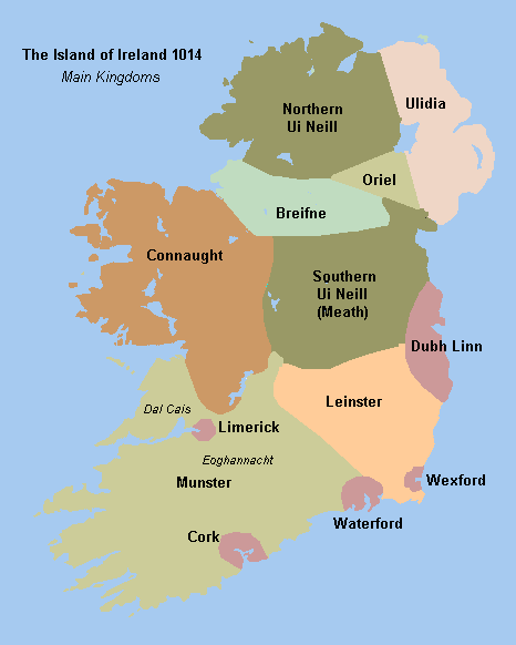
Historical map of Ireland circa 1014 from http://www.wesleyjohnston.com/users/ireland/maps/historical/map1014.gif


 | This image was uploaded as GIF, while a different format would have been more suitable. Commons discourages the use of GIF files, except for animations. See Commons:File types for more information.
If possible, please upload a PNG version (or JPEG for some photos) of this image, and mark the GIF image as {{Superseded|‹new image name›}}. If you like, encourage other Wikimedia projects using the GIF to use the new version instead. If this image is a diagram or other image suitable for vectorisation, please tag this image with {{Convert to SVG}} instead of {{BadGIF}}. If not suitable for vectorisation, use {{Convert to PNG}}. For more information, see {{BadGIF}}. беларуская (тарашкевіца) ∙ català ∙ čeština ∙ Deutsch ∙ English ∙ español ∙ فارسی ∙ suomi ∙ français ∙ עברית ∙ magyar ∙ italiano ∙ 日本語 ∙ македонски ∙ മലയാളം ∙ Plattdüütsch ∙ Nederlands ∙ português ∙ русский ∙ sicilianu ∙ українська ∙ 中文 ∙ 简体中文 ∙ 繁體中文 ∙ 台灣正體 ∙ +/− |
Litsenziyalash

|
The copyright holder of this file, The Ireland Story, allows anyone to use it for any purpose, provided that the copyright holder is properly attributed. Redistribution, derivative work, commercial use, and all other use is permitted. |
Attributsiya:
The Ireland Story Attribution |
Captions
Add a one-line explanation of what this file represents
Items portrayed in this file
tasvirlangan ob'ekt
image/gif
Fayl tarixi
Faylning biror paytdagi holatini koʻrish uchun tegishli sana/vaqtga bosingiz.
| Sana/Vaqt | Miniatura | Oʻlchamlari | Foydalanuvchi | Izoh | |
|---|---|---|---|---|---|
| joriy | 18:49, 29-Avgust 2009 | | 466 × 582 (10 KB) | The Illusional Ministry | Fixed borders and colours. |
| 18:25, 30-Noyabr 2006 |  | 466 × 582 (13 KB) | Electionworld | {{PD-because|see image}} |
Fayllarga ishoratlar
Bu faylga bogʻlangan sahifalar yoʻq.
Faylning global foydalanilishi
Ushbu fayl quyidagi vikilarda ishlatilyapti:
- ar.wikipedia.org loyihasida foydalanilishi
- be.wikipedia.org loyihasida foydalanilishi
- ca.wikipedia.org loyihasida foydalanilishi
- cs.wikipedia.org loyihasida foydalanilishi
- de.wikipedia.org loyihasida foydalanilishi
- en.wikipedia.org loyihasida foydalanilishi
- Connacht
- Battle of Clontarf
- List of Irish kingdoms
- Portal:Ireland
- Domnall Ua Lochlainn
- Muirchertach Ua Briain
- History of Ireland (1169–1536)
- Treaty of Windsor (1175)
- Talk:Ulaid
- Kingdom of Breifne
- Gaelic Ireland
- User talk:Fergananim/ArchiveIV
- Donnchad mac Briain
- Ruaidrí na Saide Buide Ua Conchobair
- User:Angusmclellan/Muirchertach Ua Briain
- Wikipedia:Reference desk/Archives/Humanities/2009 February 21
- User:Mrchris/Timeline of County Kilkenny
- History of Ireland
- Wikipedia talk:WikiProject Northern Ireland/Archive 1
- es.wikipedia.org loyihasida foydalanilishi
- eu.wikipedia.org loyihasida foydalanilishi
- fa.wikipedia.org loyihasida foydalanilishi
- fi.wikipedia.org loyihasida foydalanilishi
- fr.wikipedia.org loyihasida foydalanilishi
- ga.wikipedia.org loyihasida foydalanilishi
- gl.wikipedia.org loyihasida foydalanilishi
Ushbu faylni koʻproq global foydalanishdan koʻring.