فائل:Ktobmap.PNG
From Wikipedia, the free encyclopedia
اس سے زیادہ ریزولیوشن دستیاب نہیں۔
Ktobmap.PNG (358 × 420 پکسل، فائل کا حجم: 45 کلوبائٹ، MIME قسم: image/png)
یہ فائل ویکی ذخائر کی ہے اور دیگر منصوبوں کے زیر استعمال ہوسکتی ہے۔ فائل کے صفحہ تعارف پر موجود تعارف ذیل میں موجود ہے۔
خلاصہ
| تفصیلKtobmap.PNG |
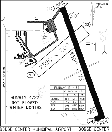
English: The airport diagram for Dodge Center Airport |
| تاریخ | 02:49, 27 July 2011 (UTC) |
| ماخذ | FAA/MnDot |
| مصنف | FAA |
اجازہ کاری
| Public domainPublic domainfalsefalse |
| This image is a work of a United States Department of Transportation employee, taken or made as part of that person's official duties. As a work of the U.S. federal government, the image is in the public domain.
|
Captions
Add a one-line explanation of what this file represents
Items portrayed in this file
عکاسی
media type انگریزی
image/png
فائل کا تاریخچہ
کسی خاص وقت یا تاریخ میں یہ فائل کیسی نظر آتی تھی، اسے دیکھنے کے لیے اس وقت/تاریخ پر کلک کریں۔
| تاریخ/وقت | تھمب نیل | ابعاد | صارف | تبصرہ | |
|---|---|---|---|---|---|
| رائج الوقت | 02:49، 27 جولائی 2011ء | | 358 × 420 (45 کلوبائٹ) | Tornado9989 | {{Information |Description = The airport diagram for Dodge Center Airport |Source = FAA/MnDot |Date = ~~~~~ |Author = FAA |Permission = |other_versions = }} |
روابط
درج ذیل صفحہ اس فائل کو استعمال کر رہا ہے:
اخذ کردہ از «https://ur.wikipedia.org/wiki/فائل:Ktobmap.PNG»