File:Mapa_Geografico_de_America_Meridional_(1790).jpg
From Wikipedia, the free encyclopedia
اصل فائل (1,059 × 1,497 پکسل، فائل کا حجم: 558 کلوبائٹ، MIME قسم: image/jpeg)
یہ فائل ویکی ذخائر کی ہے اور دیگر منصوبوں کے زیر استعمال ہوسکتی ہے۔ فائل کے صفحہ تعارف پر موجود تعارف ذیل میں موجود ہے۔
خلاصہ
| تفصیلMapa Geografico de America Meridional (1790).jpg |
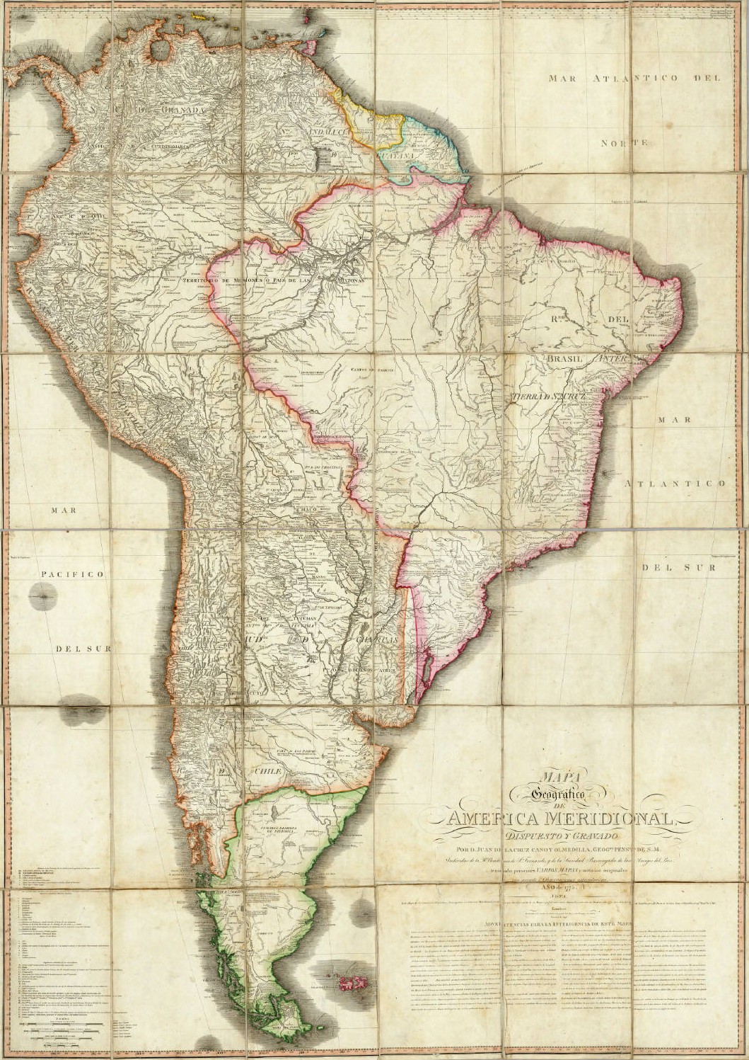
English: Geographical Map of South America, Drawn and Engraved by Mr. Juan de la Cruz Cano y Olmedilla, Geographer to His Majesty...
Español: Mapa Geografico de America Meridional, dispuesto y gravado por D. Juan de la Cruz Cano y Olmedilla, Geogfo. Pensdo. de S. M. Individuo de la R. Academia de Sn. Fernando, y da la Sociedad Bascongada de los Amigos del Pais, teniendo presentes Varios Mapas y noticias originales con arreglo a Observaciones astronómicas (Año 1775.) Londres, Publicado por William Faden, Geografo del Rey, y del Principe de Gales, Enero 1 de 1799. |
||||||||||||||||||||||
| تاریخ | 1775, reprinted 1799 | ||||||||||||||||||||||
| ماخذ | Unknown sourceUnknown source | ||||||||||||||||||||||
| مصنف |
creator QS:P170,Q8008902 |
||||||||||||||||||||||
| دوسرے نسخے |
|
||||||||||||||||||||||
.jpg)
اجازہ کاری
|
This is a faithful photographic reproduction of a two-dimensional, public domain work of art. The work of art itself is in the public domain for the following reason:
The official position taken by the Wikimedia Foundation is that "faithful reproductions of two-dimensional public domain works of art are public domain".
This photographic reproduction is therefore also considered to be in the public domain in the United States. In other jurisdictions, re-use of this content may be restricted; see Reuse of PD-Art photographs for details. | |||||
Captions
Items portrayed in this file
عکاسی
1790
فائل کا تاریخچہ
کسی خاص وقت یا تاریخ میں یہ فائل کیسی نظر آتی تھی، اسے دیکھنے کے لیے اس وقت/تاریخ پر کلک کریں۔
| تاریخ/وقت | تھمب نیل | ابعاد | صارف | تبصرہ | |
|---|---|---|---|---|---|
| رائج الوقت | 02:37، 14 مئی 2006ء | | 1,059 × 1,497 (558 کلوبائٹ) | Fbaltra | |
| 02:32، 14 مئی 2006ء |  | 1,097 × 1,536 (360 کلوبائٹ) | Fbaltra | == Summary == Mapa Geografico de America Meridional de Juan de la Cruz Cano y Olmedilla, 1790. Publicado en 1799 por William Faden, Londres. == Licensing == {{PD-Art}} Category:Historical maps of South America Category:Historical maps of Chile |
روابط
اس فائل سے مربوط کوئی صفحہ موجود نہیں ہے۔
فائل کا عالمی استعمال
مندرجہ ذیل ویکیوں میں یہ فائل زیر استعمال ہے:
- de.wikipedia.org پر استعمال
- en.wikipedia.org پر استعمال
- es.wikipedia.org پر استعمال
- it.wikipedia.org پر استعمال
- roa-tara.wikipedia.org پر استعمال
میٹا ڈیٹا
اِس فائل میں اِضافی معلومات شامل ہیں، جو شاید اُس ڈیجیٹل کیمرے یا اِسکینر سے آئی ہیں جس کے ذریعے یہ فائل بنائی گئی تھی۔
اگر فائل اپنی اصل حالت میں نہ ہو تو کچھ معلومات ترمیم شدہ فائل کی مکمل طور پر عکاسی نہیں کر پائیں گی۔
| _error | 0 |
|---|
.jpg)