File:East-Hem_476ad.jpg
З Вікіпедії, безкоштовно encyclopedia
Повна роздільність (3240 × 1903 пікселів, розмір файлу: 754 КБ, MIME-тип: image/jpeg)
| Відомості про цей файл містяться на Вікісховищі — централізованому сховищі вільних файлів мультимедіа для використання у проектах Фонду Вікімедіа. |

|
Це зображення невідомого типу «historical map» має бути конвертоване у векторний формат SVG. Це дає декілька переваг, докладніше про які Ви можете прочитати на сторінці Commons:Media for cleanup. Якщо Вам вже зараз доступна векторна версія даного зображення, завантажте її, будь ласка. Після завантаження замініть цей шаблон на такий: {{vector version available|Назва_завантаженого_файлу.svg}}.
|
 | Цей файл був завантажений у форматі JPEG, навіть не зважаючи на те, що він складається з не фотографічних даних. Ця інформація може бути збережена ефективніше або точніше у форматі PNG або форматі SVG. Якщо можливо, будь ласка, завантажте PNG або SVG версію цього зображення без артефактів стиснення, що походить з не-JPEG джерела (або із видаленням наявних артефактів). Після цього, будь ласка, позначте JPEG версію наступним чином {{Superseded|Нове зображення.ext}} та вилучіть цю мітку. Ця мітка не повинна застосовуватись до фотографій та сканів. Задля подробиць, див. {{BadJPEG}}. |  |
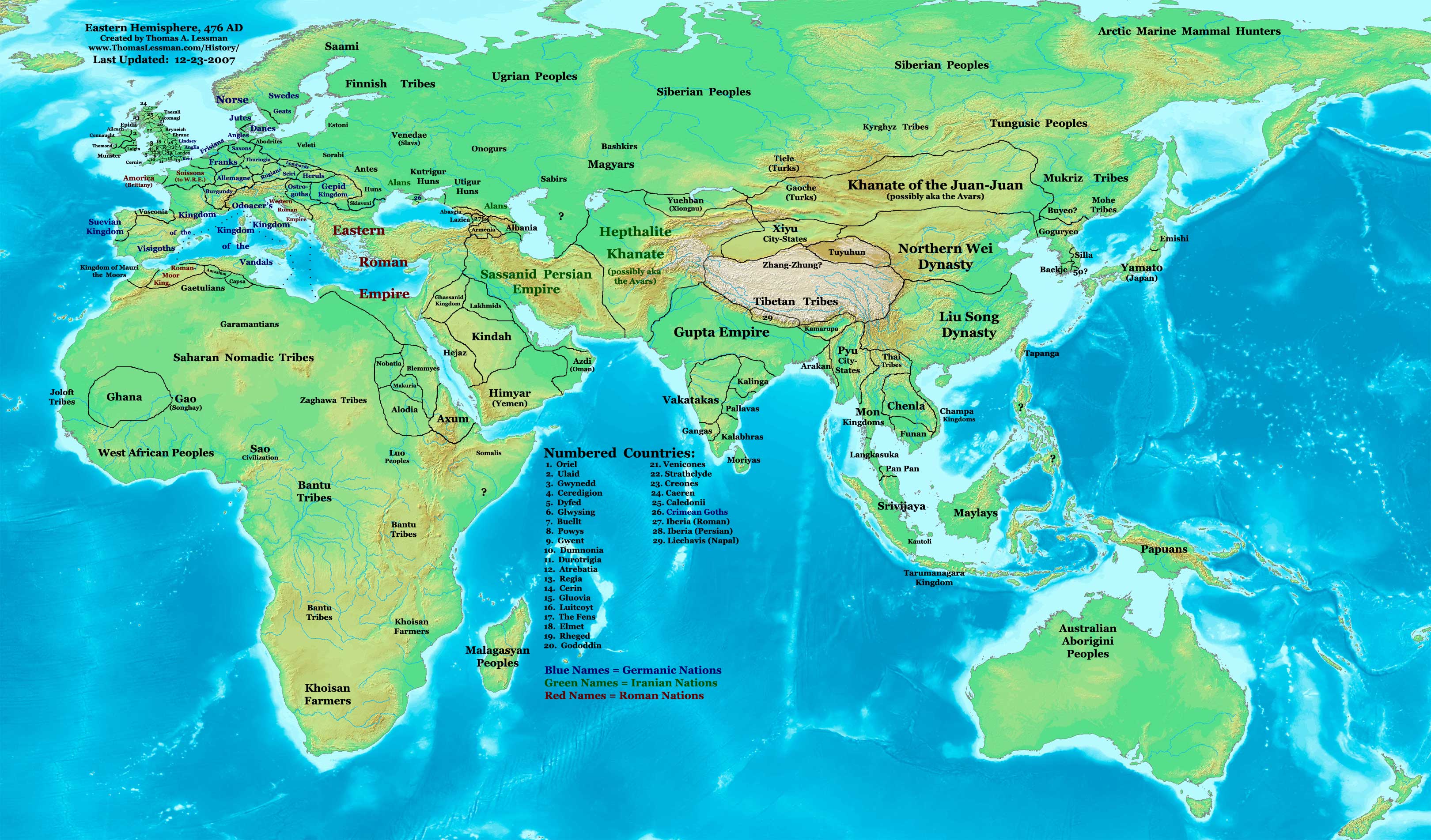
| ОписEast-Hem 476ad.jpg | Eastern Hemisphere in 476 AD. | |||
| Джерело | self-made (For reference information, see the Map Source References section below.) | |||
| Автор | Thomas Lessman (Contact!) | |||
| Ліцензія (Повторне використання цього файлу) |
Я, власник авторських прав на цей твір, добровільно публікую його на умовах такої ліцензії: Цей файл ліцензований на умовах ліцензії Creative Commons Attribution-Share Alike 3.0 Unported
|
|||
| Інші версії |
|
.jpg)
Зміст
Map Summary
Original Source URL: http://www.thomaslessman.com/History/images/East-Hem_476ad.jpg.
This map of the Eastern Hemisphere in 476 AD was created by Thomas Lessman, based on information from the sources listed below. This map is free for educational use (see Permission info above). When using this map, please mention that it is available for free at www.WorldHistoryMaps.info.
Map Source References
- Remember, sources often conflict with each other. This map is only as accurate as the information that is available to me. To report any errors or to help further this work, please click here, or email Thomas Lessman at talessman@yis.us
References for information contained in this map:
1. The DK Atlas of World History, 2000 Edition; map of The World in 500 CE, (Pages 50-51) was used for information on several borders in this map.
2. Borders of Europe are mostly derived from the Euratlas.com map of Europe in 500 AD.
- a - Borders of Britain are derived from the "EarlyBritishKingdoms.com", map of map Britain in 475 AD.
3. Borders of Asia are derived mostly from the following sources:
- a - various Wikipedia articles and Google history map searches.
- (More info will be added soon)
4. Some information is derived from Wikimedia's map of The world in 500 CE, created by User:Javierfv1212.
5. Much of the information in this map was cross-checked with Bruce Gordon's Regnal Chronologies.
Other Historical Maps by Thomas Lessman
| Maps of the eastern hemisphere showing history
Bold dates are available on Wikimedia or Wikipedia. | ||
| Primeval | ||
| Ancient
|
·| 600 BC | 550 BC | 527 BC | 500 BC |
400 BC | ·| 1 AD | 50 AD | 100 AD | 200 AD | 300 AD | | |
| Medieval |
·| 500 AD | 565 AD | 600 AD | 700 AD | | |
| Modern |
·| 1500 AD | · * For historical maps of the whole world, | |
| history links talk edit view | ||
Журнал завантажень локального файлу
- 2007-12-23 11:36 Talessman 3240×1903×8 (771644 bytes) Added numbered legend. Added more info for Manchuria, central Asia, Indonesia, Africa, and British Isles.
- 2007-11-06 22:07 Talessman 3240×1903×8 (718060 bytes) Updated borders for Sudan and Arabia.
- 2007-10-30 00:25 Talessman 3240×1903×8 (718905 bytes) Updated info on far eastern islands, Japan, Indonesia, etc.
- 2007-09-26 15:42 Talessman 2880×1692×8 (572882 bytes) Author: Thomas A. Lessman. Source URL: http://www.ThomasLessman.com/History/images/East-Hem_476ad.jpg. Image was created by me (Thomas Lessman) based on historical information located on Wikipedia, as well as information from maps located in Wikipedia and
- 2007-09-12 21:08 Talessman 2942×1728×8 (578540 bytes) Reverted to version as of 20:43, 12 September 2007
- 2007-09-12 20:44 Talessman 2942×1728×8 (578540 bytes) Reverted to version as of 19:32, 12 September 2007
- 2007-09-12 20:43 Talessman 2942×1728×8 (578540 bytes) Author: Thomas A. Lessman. Source URL: http://www.ThomasLessman.com/History/images/East-Hem_476ad.jpg. Image was created by me (Thomas Lessman) based on historical information located on Wikipedia, as well as information from maps located in Wikipedia and
- 2007-09-12 19:32 Talessman 2942×1728×8 (578540 bytes) Author: Thomas A. Lessman. Source URL: http://www.ThomasLessman.com/History/images/East-Hem_476ad.jpg. Image was created by me (Thomas Lessman) based on historical information located on Wikipedia, as well as information from maps located in Wikipedia and
- 2007-08-23 19:15 Talessman 1973×1159×8 (2352602 bytes) Reverted to earlier revision
- 2007-08-23 19:15 Talessman 1973×1159×8 (2373060 bytes) Author: Thomas A. Lessman. Source URL: http://www.ThomasLessman.com/History/images/East-Hem_600ad.jpg. Image was created by me (Thomas Lessman) based on historical information located on Wikipedia, as well as information from maps located in Wikipedia and
- 2007-08-23 19:12 Talessman 1973×1159×8 (2373060 bytes) Author: Thomas A. Lessman. Source URL: http://www.ThomasLessman.com/History/images/East-Hem_600ad.jpg. Image was created by me (Thomas Lessman) based on historical information located on Wikipedia, as well as information from maps located in Wikipedia and
- 2007-07-21 20:15 Talessman 1973×1159×8 (2352602 bytes) Author: Thomas A. Lessman. Source URL: http://www.ThomasLessman.com/History/images/East-Hem_476ad.jpg. Image was created by me (Thomas Lessman) based on historical information located on Wikipedia, as well as information from maps located in Wikipedia and
Підписи
Об'єкти, показані на цьому файлі
зображує
Історія файлу
Клацніть на дату/час, щоб переглянути, як тоді виглядав файл.
| Дата/час | Мініатюра | Розмір об'єкта | Користувач | Коментар | |
|---|---|---|---|---|---|
| поточний | 14:32, 18 квітня 2008 | | 3240 × 1903 (754 КБ) | Rottweiler | {{Information |Description=== Summary == Author: Thomas A. Lessman. Source URL: http://www.ThomasLessman.com/History/images/East-Hem_476ad.jpg. Image was created by Thomas Lessman based on historical information located in sources listed below. This map i |
Використання файлу
Нема сторінок, що використовують цей файл.
Глобальне використання файлу
Цей файл використовують такі інші вікі:
- Використання в de.wikipedia.org
- Використання в en.wikipedia.org
- Використання в id.wikipedia.org
- Використання в jv.wikipedia.org
- Використання в rue.wikipedia.org
- Використання в ru.wikipedia.org
- Використання в sv.wikipedia.org
Метадані
Файл містить додаткові дані, які зазвичай додаються цифровими камерами чи сканерами. Якщо файл редагувався після створення, то деякі параметри можуть не відповідати цьому зображенню.
| _error | 0 |
|---|