File:Africa_relief_location_map-no_borders.jpg
From Wikipedia, the free encyclopedia
Saizi ya chakuona ichi: 635 × 600 pixels. Mu misani inyake: 254 × 240 pixels | 508 × 480 pixels | 813 × 768 pixels | 1,084 × 1,024 pixels | 1,525 × 1,440 pixels.
Chinthu cha kwenekuko (1,525 × 1,440 pixels, file size: 549 KB, MIME type: image/jpeg)
Chinthu ichi ntchaku Wikimedia Commons ndipo chingagwiliskikaso kunyake. Vakulongosola vake file description page vili pasi apa.

|
This map image could be re-created using vector graphics as an SVG file. This has several advantages; see Commons:Media for cleanup for more information. If an SVG form of this image is available, please upload it and afterwards replace this template with
{{vector version available|new image name}}.
It is recommended to name the SVG file “Africa relief location map-no borders.svg”—then the template Vector version available (or Vva) does not need the new image name parameter. |
 | This map image was uploaded in the JPEG format even though it consists of non-photographic data. This information could be stored more efficiently or accurately in the PNG or SVG format. If possible, please upload a PNG or SVG version of this image without compression artifacts, derived from a non-JPEG source (or with existing artifacts removed). After doing so, please tag the JPEG version with {{Superseded|NewImage.ext}} and remove this tag. This tag should not be applied to photographs or scans. If this image is a diagram or other image suitable for vectorisation, please tag this image with {{Convert to SVG}} instead of {{BadJPEG}}. If not suitable for vectorisation, use {{Convert to PNG}}. For more information, see {{BadJPEG}}. |  |
Mwakudumula
| MalongosoleloAfrica relief location map-no borders.jpg |
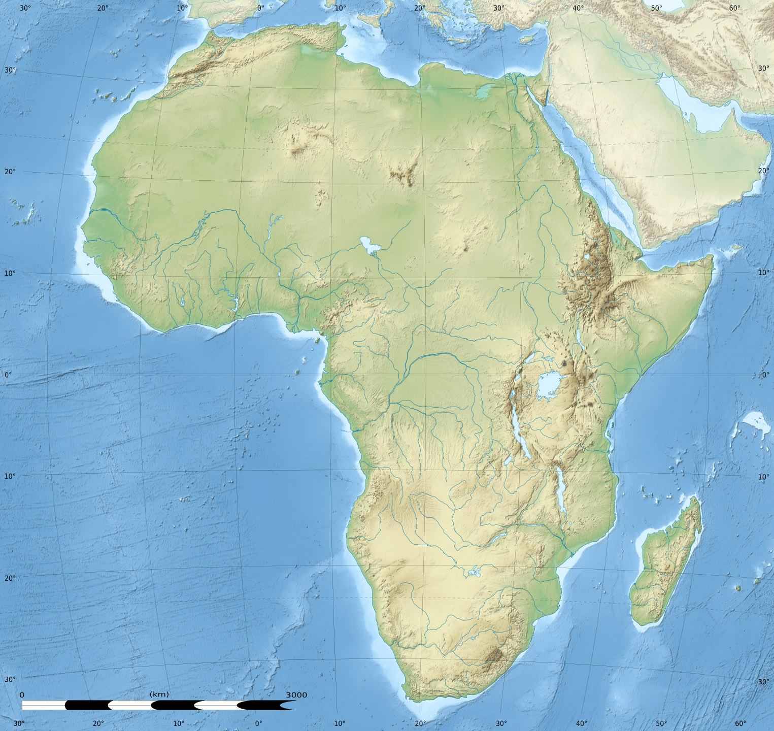
English: Blank physical map of Africa, without international boundaries, for geo-location purposes.
Français : Carte physique vierge de l'Afrique, sans frontières, destinée à la géolocalisation. Lambert azimutal equal-area projection, WGS84 datum
|
||
| Siku | |||
| Ukaboni |
Based upon File:Africa_map_blank.svg created by myself
|
||
| Mlembi | Eric Gaba (Sting - fr:Sting) | ||
| Chilolezo (Kugwiliskaso ntchito ichi) |
|
||
| Other versions |
|


| Camera location | 0° 00′ 00″ N, 15° 00′ 00″ E | View this and other nearby images on: OpenStreetMap |
|---|
This map was improved or created by the Wikigraphists of the Graphic Lab (fr). You can propose images to clean up, improve, create or translate as well. |
Chilolezo
Eric Gaba, Wikimedia Commons user Sting, the copyright holder of this work, hereby publishes it under the following licenses:

|
Chilolezo ntchakupelekeka pakupanga copy, kutandazga panj kusintha na malango gha GNU Free Documentation License, Version 1.2 or any later version published by the Free Software Foundation; with no Invariant Sections, no Front-Cover Texts, and no Back-Cover Texts. A copy of the license is included in the section entitled GNU Free Documentation License.http://www.gnu.org/copyleft/fdl.htmlGFDLGNU Free Documentation Licensetruetrue |
Chinthu ichi ntchakuzomelezgeka na Creative Commons Attribution-Share Alike 3.0 Unported license.
Attribution: Eric Gaba, Wikimedia Commons user Sting
- Ndimwe ŵakuzomelezgeka:
- kugaŵa – kuti mutandazge, kugaŵa na kusintha ntchito
- kusazga – kusintha chito iyi
- Pa malango ghakulondezga agha:
- Viyambilo vya kuchita – Mukwenela kupeleka malumbo ghawemi, kupeleka linki yakutyonda ku chilolezo, kweneso yowoyaniso pala vinyake vyasintha. Mukwenela kuchita nthena mwakwenelela, kwambula kujikhalila khonde.
- mwa kugaŵana – Pala mwasazga panji mwasintha chinthu, mukwenela kuchitandazga
You may select the license of your choice.
Captions
Add a one-line explanation of what this file represents
Items portrayed in this file
depicts English
copyright status English
copyrighted English
inception English
Julayi 2010
coordinates of the point of view English
0°0'0.000"N, 15°0'0.000"E
media type English
image/jpeg
checksum English
6755f647679353b8ba5ef0d3c41599b2ee71deed
data size English
562,563 byte
height English
1,440 pixel
width English
1,525 pixel
Mbili ya chinthu
Dofyani pa siku/nyengo kuti muone umo vikaonekela pa nyengo iyo.
| Siku/Nyengo | Kachithuzi | Vipimo | Mgwiliski | Ganizo | |
|---|---|---|---|---|---|
| sono | 15:48, 18 Okutobala 2012 | | 1,525 × 1,440 (549 KB) | Sting | == {{int:filedesc}} == {{Information |Description={{en|Blank physical map of Africa, without international boundaries, for geo-location purposes.}} {{fr|Carte physique vierge de l'Afrique, sans frontières, destinée à l... |
Magwiliskilo ntchito
Palije majani agho ghogwiliska chinthu ichi.
Metadata
Chinthu ichi china vyakulemba vinyake ivo panji vikasazgika pa siku ilo kamela ikajambulilanga, panji apo makina gha ghakulemba ghakajambulila.
Pala chinthu chakwamba chasinthika, vyakulemba vinandi vikuukako.
| Author | Eric Gaba |
|---|---|
| Copyright holder |
|
| Orientation | Normal |
| Horizontal resolution | 89.9922 dpi |
| Vertical resolution | 89.9922 dpi |
| Software used | Adobe Photoshop CS6 (Windows) |
| File change date and time | 12:41, 18 Okutobala 2012 |
| Color space | Uncalibrated |
| Date and time of digitizing | 09:38, 18 Okutobala 2012 |
| Date metadata was last modified | 09:41, 18 Okutobala 2012 |
| Copyright status | Copyrighted |
| Unique ID of original document | xmp.did:C9E7B5393A19E2119BF9ED001B0EFBC2 |
| IIM version | 2 |