File:Europe_1867_map_en.png
From Wikipedia, the free encyclopedia
Bu önizlemenin boyutu: 800 × 526 piksel. Diğer çözünürlükler: 320 × 211 piksel | 640 × 421 piksel | 1.024 × 674 piksel | 1.280 × 842 piksel | 2.284 × 1.503 piksel.
Tam çözünürlük ((2.284 × 1.503 piksel, dosya boyutu: 1,07 MB, MIME tipi: image/png))
Bu dosya Wikimedia Commons'ta bulunmaktadır. Dosyanın açıklaması aşağıda gösterilmiştir. Commons, serbest/özgür telifli medya dosyalarının bulundurulduğu depodur. Siz de yardım edebilirsiniz. |
Özet
| AçıklamaEurope 1867 map en.png |
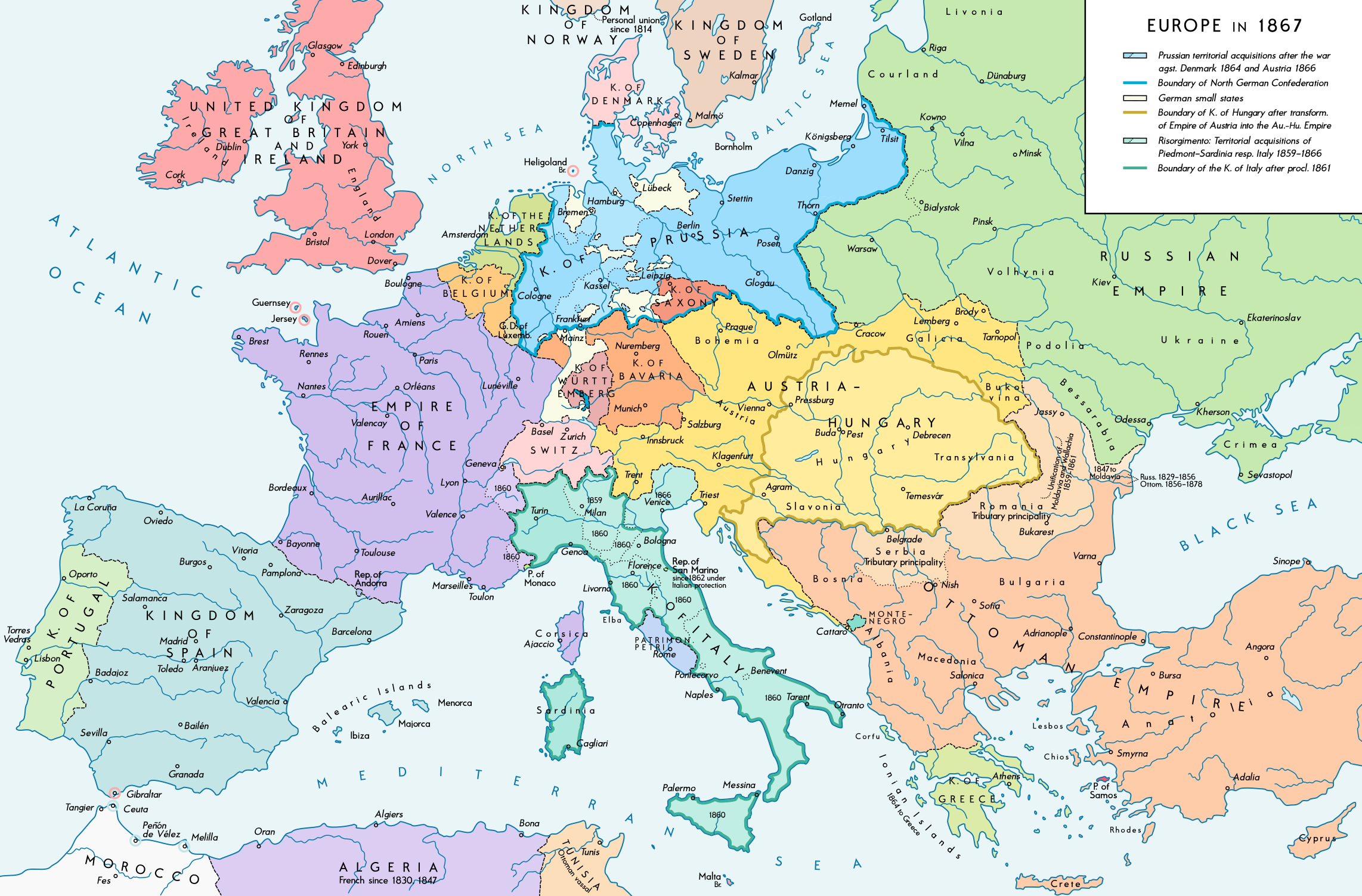
English: Europe 1867. Historical map of the political situation after the forming of the North German Confederation, the Italian Risorgimento (with the exception of the Roman part of the Papal States) and the Austro-Hungarian Compromise of 1867. Please don't alter the map, when you think there something not written or depicted correctly. Leave a message at the talk page of the file. After a verificiation and a possible discussion, i will upload a new map version with all new changes. This prevents an unnecessary waste of disc space and ensures a good result, aesthetically and contentwise. - The author. Deutsch: Europa 1867. Historische Karte der politischen Situation in Europa nach der Gründung des Norddeutschen Bundes, des italienischen Risorgimento (mit Ausnahme des röm. Teils des Kirchenstaats) und dem Österreichisch-Ungarischen Ausgleich von 1867. Bitte die Karte bei Änderungs- und Korrekturwünschen nicht selbst verändern, sondern eine Anmerkung im Diskussionsbereich der Bilddatei hinterlassen. Nach einer Prüfung und ggfs. Diskussion werden evtl. Änderungen von mir zusammengefasst eingearbeitet. Das vermeidet unnötige Speicherplatz-Verschwendung und gewährleistet ein ästhetisch ansprechendes und inhaltlich korrektes Ergebnis. - Der Urheber. |
| Tarih | |
| Kaynak |
Yükleyenin kendi çalışması. Source of Information: Historical atlases and maps – Ramsay Muir, George Philip (ed.): Philip's New School Atlas of Universal History, George Philip & Son, Ltd., London 1928 – Dr. Walter Leisering (ed.): Putzger Historischer Weltatlas, Cornelsen Verlag, Berlin 1992, ISBN 3-464-00176-8 – Bayerischer Schulbuch-Verlag (ed.): Großer Historischer Weltatlas, Dritter Teil, Neuzeit, Bayerischer Schulbuch-Verlag, München 1981, ISBN 3-7627-6021-7. – Prof. Dr. Vadim Oswalt u. Prof. Dr. Hans Ulrich Rudolf (ed.): Klett-Perthes Atlas zur Weltgeschichte, Ernst Klett Verlag, Stuttgart 2011, ISBN 978-3-12-828194-0 – Ziegelbrenner: Karte des Norddeutschen Bundes 1866–1871, 6 June 2014 version (map link) Other publications – Francesco Traniello u. Gianni Sofri: Der lange Weg zur Nation. Das italienische Risorgimento, Verlag W. Kohlhammer, Stuttgart 2012, ISBN 978-3-17-021898-7 |
| Yazar | Alexander Altenhof |
| Diğer sürümler |
|

Recompressed without quality loss with OptiPNG (1.35 MB > 1.06 MB)
Lisanslama
Ben, bu işin telif sahibi, burada işi aşağıdaki lisans altında yayımlıyorum:
Bu dosya, Creative Commons Atıf-Benzer Paylaşım 4.0 Uluslararası lisansı ile lisanslanmıştır.
- Şu seçeneklerde özgürsünüz:
- paylaşım – eser paylaşımı, dağıtımı ve iletimi
- içeriği değiştirip uyarlama – eser adaptasyonu
- Aşağıdaki koşullar geçerli olacaktır:
- atıf – Esere yazar veya lisans sahibi tarafından belirtilen (ancak sizi ya da eseri kullanımınızı desteklediklerini ileri sürmeyecek bir) şekilde atıfta bulunmalısınız.
- benzer paylaşım – Maddeyi yeniden karıştırır, dönüştürür veya inşa ederseniz, katkılarınızı orijinal olarak aynı veya uyumlu lisans altında dağıtmanız gerekir.
Altyazılar
Bu dosyanın temsil ettiği şeyin tek satırlık açıklamasını ekleyin.
Bu dosyada gösterilen öğeler
betimlenen
Vikiveri ögesi olmayan bir değer
4 Eylül 2016
Dosya geçmişi
Dosyanın herhangi bir zamandaki hâli için ilgili tarih/saat kısmına tıklayın.
| Tarih/Saat | Küçük resim | Boyutlar | Kullanıcı | Yorum | |
|---|---|---|---|---|---|
| güncel | 23.42, 14 Nisan 2017 | | 2.284 × 1.503 (1,07 MB) | KaterBegemot | Empire of France (not Kingdom), changed main caption to "Europe in 1867", fixed font size of "Piedmont-Sardinia", minor changes |
| 21.36, 4 Eylül 2016 |  | 2.284 × 1.503 (1,06 MB) | KaterBegemot | {{Information |Description ={{en|1=Europe 1867. Historical map of the political situation after the forming of the North German Confederation, the Italian Risorgimento (with the exception of the Roman part of the Papal States) and the Austro-Hungari... |
Dosya kullanımı
Bu görüntü dosyasına bağlanan sayfa yok.
Küresel dosya kullanımı
Aşağıdaki diğer vikiler bu dosyayı kullanır:
- ast.wikipedia.org üzerinde kullanımı
- en.wikipedia.org üzerinde kullanımı
- et.wikipedia.org üzerinde kullanımı
- it.wikipedia.org üzerinde kullanımı
Meta veri
Bu dosyada, muhtemelen fotoğraf makinesi ya da tarayıcı tarafından eklenmiş ek bilgiler mevcuttur. Eğer dosyada sonradan değişiklik yapıldıysa, bazı bilgiler yeni değişikliğe göre eski kalmış olabilir.
| Yatay çözünürlük | 70 dpi |
|---|---|
| Dikey çözünürlük | 70 dpi |
| Renk aralığı | Kalibrasyonsuz |
| Resim genişliği | 2.284 px |
| Resim yüksekliği | 1.503 px |
| Kullanılan yazılım | Adobe Photoshop CC 2017 (Windows) |
| Dijitalleştirme zamanı | 03.05, 15 Nisan 2017 |
| Dosya değişiklik tarihi ve zamanı | 03.22, 15 Nisan 2017 |
| Üst veri son değişim tarihi | 03.22, 15 Nisan 2017 |
| Özgün belgenin benzersiz kimliği | xmp.did:fd41fa5f-5199-fd40-bec6-d1a7668cc651 |
"https://tr.wikipedia.org/wiki/Dosya:Europe_1867_map_en.png" sayfasından alınmıştır