File:ElectoralCollege1992-Large.png
From Wikipedia, the free encyclopedia
Bu önizlemenin boyutu: 800 × 430 piksel. Diğer çözünürlükler: 320 × 172 piksel | 640 × 344 piksel | 1.182 × 635 piksel.
Tam çözünürlük ((1.182 × 635 piksel, dosya boyutu: 174 KB, MIME tipi: image/png))
Bu dosya Wikimedia Commons'ta bulunmaktadır. Dosyanın açıklaması aşağıda gösterilmiştir. Commons, serbest/özgür telifli medya dosyalarının bulundurulduğu depodur. Siz de yardım edebilirsiniz. |
| U.S. presidential election maps from the National Atlas of the United States |
| See also: SVG maps |
| 1789 · 1792 · 1796 · 1800 · 1804 · 1808 · 1812 · 1816 · 1820 · 1824 · 1828 · 1832 · 1836 · 1840 · 1844 · 1848 · 1852 · 1856 · 1860 · 1864 · 1868 · 1872 · 1876 · 1880 · 1884 · 1888 · 1892 · 1896 · 1900 · 1904 · 1908 · 1912 · 1916 · 1920 · 1924 · 1928 · 1932 · 1936 · 1940 · 1944 · 1948 · 1952 · 1956 · 1960 · 1964 · 1968 · 1972 · 1976 · 1980 · 1984 · 1988 · 1992 · 1996 · 2000 · 2004 |
Özet
| AçıklamaElectoralCollege1992-Large.png |
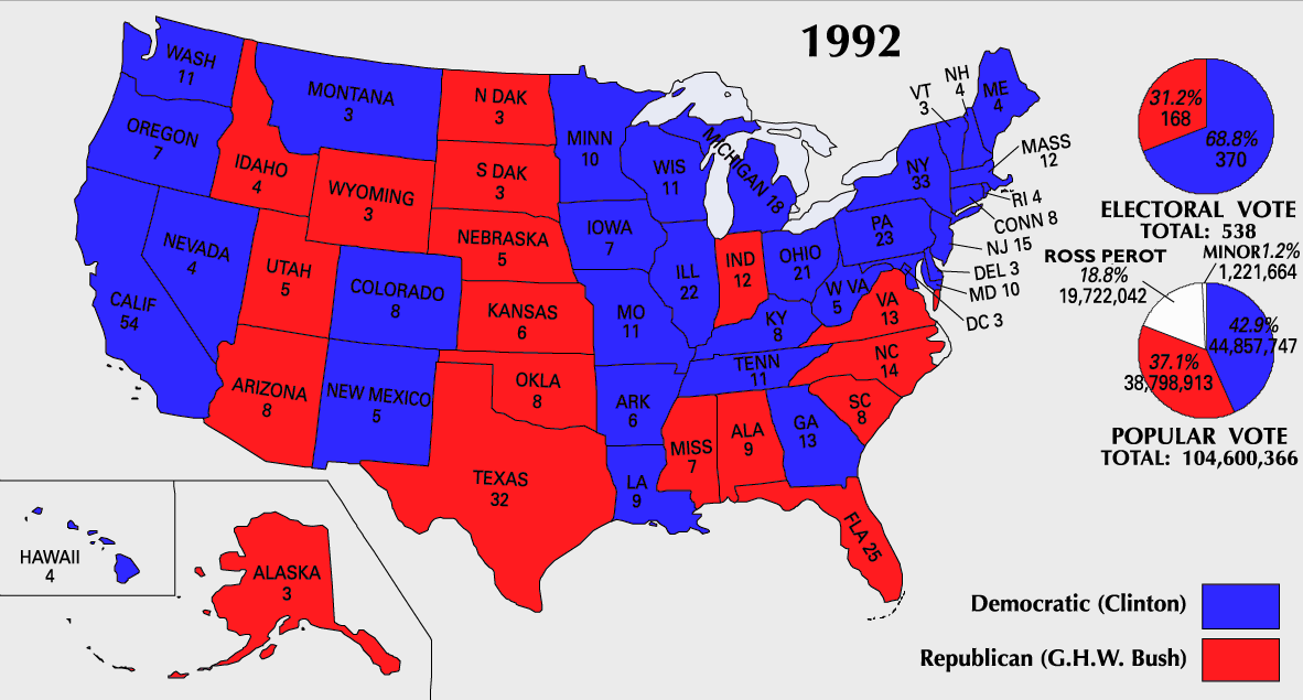
English: 1992 Electoral College Map |
||
| Kaynak | https://nationalmap.gov/small_scale/printable/elections.html | ||
| Yazar | ABD Jeoloji Araştırmaları Kurumu | ||
| Diğer sürümler |
|

Lisanslama
| Public domainPublic domainfalsefalse |
This map was obtained from an edition of the National Atlas of the United States. Like almost all works of the U.S. federal government, works from the National Atlas are in the public domain in the United States.
Online access: NationalAtlas.gov | 1970 print edition: Library of Congress, Perry-Castañeda Library čeština | Deutsch | English | français | Bahasa Indonesia | italiano | македонски | മലയാളം | sicilianu | 中文 | 中文(简体) | 中文(繁體) | +/− |
Dosya geçmişi
Dosyanın herhangi bir zamandaki hâli için ilgili tarih/saat kısmına tıklayın.
| Tarih/Saat | Küçük resim | Boyutlar | Kullanıcı | Yorum | |
|---|---|---|---|---|---|
| güncel | 10.21, 25 Temmuz 2007 | | 1.182 × 635 (174 KB) | Cardsplayer4life~commonswiki | Reverted to earlier revision |
| 09.28, 25 Temmuz 2007 |  | 1.182 × 635 (111 KB) | Joseph Solis in Australia~commonswiki | {{PD-USGov-Atlas}} Category:1992 {{US presidential election maps}} | |
| 08.02, 13 Temmuz 2007 |  | 1.182 × 635 (174 KB) | Cardsplayer4life~commonswiki | {{PD-USGov-Atlas}} {{ConvertToSVG|map}} {{US presidential election maps}} | |
| 01.48, 9 Temmuz 2007 |  | 1.182 × 635 (174 KB) | Cardsplayer4life~commonswiki | {{PD-USGov-Atlas}} {{ConvertToSVG|map}} {{US presidential election maps}} | |
| 09.33, 6 Temmuz 2007 |  | 1.182 × 635 (111 KB) | Joseph Solis in Australia~commonswiki | {{PD-USGov-Atlas}} Category:1992 {{US presidential election maps}} | |
| 02.29, 2 Temmuz 2007 |  | 1.182 × 635 (174 KB) | Cardsplayer4life~commonswiki | {{PD-USGov-Atlas}} {{ConvertToSVG|map}} {{US presidential election maps}} | |
| 10.10, 29 Haziran 2007 |  | 1.182 × 635 (111 KB) | Joseph Solis in Australia~commonswiki | {{PD-USGov-Atlas}} Category:1992 {{US presidential election maps}} | |
| 21.01, 21 Haziran 2007 |  | 1.182 × 635 (175 KB) | Cardsplayer4life~commonswiki | {{PD-USGov-Atlas}} {{ConvertToSVG|map}} {{US presidential election maps}} | |
| 16.04, 22 Ocak 2006 |  | 1.182 × 635 (111 KB) | Red devil 666 | {{PD-USGov-Atlas}} |
Dosya kullanımı
Bu görüntü dosyasına bağlanan sayfa yok.
Küresel dosya kullanımı
Aşağıdaki diğer vikiler bu dosyayı kullanır:
- en.wikipedia.org üzerinde kullanımı
- ru.wikipedia.org üzerinde kullanımı
- sv.wikipedia.org üzerinde kullanımı
- uk.wikipedia.org üzerinde kullanımı
"https://tr.wikipedia.org/wiki/Dosya:ElectoralCollege1992-Large.png" sayfasından alınmıştır