File:Valley_of_the_Kings_from_space_STS026-041-058.tif
From Wikipedia, the free encyclopedia

Buong resolusyon ((5,700 × 5,900 pixel, laki ng talaksan: 112.83 MB, uri ng MIME: image/tiff))
|
|
Ito ay isang talaksan mula sa Wikimedia Commons. Makikita sa ibaba ang impormasyon mula sa pahina ng paglalarawan nito roon. |
Buod
| PaglalarawanValley of the Kings from space STS026-041-058.tif |
English: Valley of the Kings, Southern Egypt October 1988
Arid landforms comprise much of this nearly vertical view of a portion of the Nile River. These desert landforms include eroded valleys and wadis (watercourses). The fertile and highly productive green Nile River Valley stands out in marked contrast to the tan desert landscape on either side. This part of the Nile Valley varies in width from 4 to 9 miles (6 to 14 kilometers). Near the southern edge of this photograph, the city of Luxor can be ascertained along the eastern bank of the Nile. The narrow, linear runways of the airport are visible on the edge of the desert east of the city. This particular bend in the Nile River is the home of many historical points of interest-Valley of the Kings, Valley of the Queens, Temple of Luxor, Tomb of Tutankhamen, and Necropolis of Thebes. Italiano: Valle dei Re, Egitto Meridionale, Ottobre 1988
La maggior parte di questa fotografia, ripresa circa sulla verticale di una parte del fiume Nilo, comprende territori desertici. Questo territorio desertico include valli erose e torrenti stagionali. La verde Valle sulla riva del Nilo, fertile e molto produttiva si estende in un marcato contrasto con il panorama desertico da entrambe le rive. Questa parte della Valle del Nilo ha una larghezza che varia da 6 a 14 chilometri (4 a 6 miglia). Si può riconoscere la città di Luxor, vicino al bordo meridionale di questa fotografia, lungo la riva orientale del Nilo. A Est della città, sul bordo del deserto, sono visibili le strette e diritte piste di atterraggio dell'aeroporto. Questa particolare fascia della riva del Nilo è sede di molti punti di interesse storico come la Valle dei Re, la Valle della Regine, il Tempio di Luxor, la tomba di Tutankhamen e l'antico cimitero di Tebe. STS026-041-058 è una sigla che indica in modo univoco la fonte di questa foto, STS026 è la sigla della missione shuttle Discovery che ha ripreso la foto n° 041-058. |
| Petsa | |
| Pinanggalingan | EARTH FROM SPACE Valley of the King STS026-041-058 |
| May-akda | NASA/Crew of STS-26 |
| Iba pang mga bersyon | Tutankhamen map Valle Re Nilo space STS026-041-058.jpg – JPEG |
This image or video was catalogued by Johnson Space Center of the United States National Aeronautics and Space Administration (NASA) under Photo ID: STS026-041-058. This tag does not indicate the copyright status of the attached work. A normal copyright tag is still required. See Commons:Licensing. Other languages:
العربية ∙ беларуская (тарашкевіца) ∙ български ∙ català ∙ čeština ∙ dansk ∙ Deutsch ∙ English ∙ español ∙ فارسی ∙ français ∙ galego ∙ magyar ∙ հայերեն ∙ Bahasa Indonesia ∙ italiano ∙ 日本語 ∙ македонски ∙ മലയാളം ∙ Nederlands ∙ polski ∙ português ∙ русский ∙ sicilianu ∙ slovenščina ∙ Türkçe ∙ українська ∙ 简体中文 ∙ 繁體中文 ∙ +/− |
Paglilisensiya
| Public domainPublic domainfalsefalse |
This file is in the public domain in the United States because it was created by the Image Science & Analysis Laboratory, of the NASA Johnson Space Center. NASA copyright policy states that "NASA material is not protected by copyright unless noted". (NASA media use guidelines or Conditions of Use of Astronaut Photographs).
Photo source: STS026-041-058.
العربيَّة | Deutsch | English | español | français | italiano | kurdî | македонски | മലയാളം | português | sicilianu | +/− |
Captions
significant event English
STS-26 English
1 Oktubre 1988
catalog code English
STS026-041-058
Nakaraan ng file
Pindutin ang araw/oras upang makita kung papaano ang itsura ng talaksan noong oras na iyon.
| Araw/Oras | Thumbnail | Mga dimensiyon | tagagamit | Kumento | |
|---|---|---|---|---|---|
| ngayon | 23:44, 11 Nobyembre 2014 | 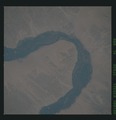 | 5,700 × 5,900 (112.83 MB) | Ras67 | User created page with UploadWizard |
Mga ugnay
Walang mga pahina ang tumuturo sa talaksang ito.
Metadata
Naglalaman ng mga karagdagang impormasyon ang talaksan na ito, marahil nadagdag mula sa kamerang digital o scanner na ginamit upang makalikha o gawing digital ito. Kung nabago ang talaksan mula sa orihinal na katayuan, maaaring hindi maipapakita ng lubusan ang detalye ng binagong larawan.
| Gumawa ng kamera | STS-26 |
|---|---|
| Modelo ng kamera | Valley of the Kings |
| Araw at oras ng paggawa ng datos | 08:33, 1 Oktubre 1988 |
| Haba | 5,700 px |
| Taas | 5,900 px |
| Mga bit bawat komponente |
|
| Iskima ng kompresyon | Paimpisin (Adobe) |
| Komposisyon ng pixel | RGB |
| Pamagat ng larawan | Valley of the Kings, Southern Egypt October 1988 |
| Oryentasyon | Karaniwan |
| Bilang ng mga komponente | 3 |
| Bilang ng mga hanay bawat strip | 30 |
| Pahigang resolusyon | 300 dpi |
| Patayong resolusyon | 300 dpi |
| Pagkakaayos ng datos | pagkaayos sa malalaking bahagi (chunky) |
| Ginamit na software | Adobe Photoshop |
| Araw at oras ng pagpapalit ng talaksan | 17:08, 11 Nobyembre 2014 |
| May akda | STS-26 crew member |
| May hawak ng karapatang-ari | NASA |
| Araw at oras ng ginawang digital | 16:13, 2 Hulyo 2013 |
| Kumento ng tagagamit | STS026-041-058 |
| Espasyo ng kulay | sRGB |