File:OttomanEmpireIn1683tr.png
From Wikipedia, the free encyclopedia
Bu synlawyň ölçegi: 637 × 599 piksel. Other resolutions: 255 × 240 piksel | 510 × 480 piksel | 816 × 768 piksel | 1 088 × 1 024 piksel | 1 966 × 1 850 piksel.
Original faýl (1 966 × 1 850 piksel, faýlyň ölçegi: 327 KB, MIME tipli: image/png)
Bu faýl Wikimedia Commons toplaýjysyndan, özem başga taslamalarda ulanylýan bolmagy mümkin. Onuň faýl düşündiriş sahypasyndaky maglumatlar aşakda görkezilýär.
Gysgaça düşündiriş
| DüşündirişOttomanEmpireIn1683tr.png |
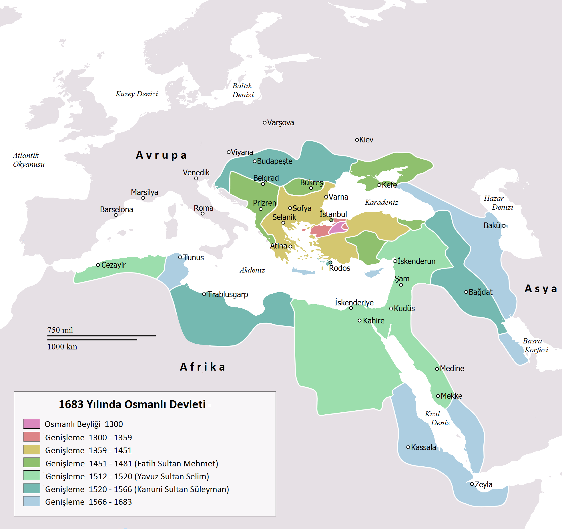
English: Map depicting the Ottoman Empire at its greatest extent, in 1683.
Türkçe: 1683 yılına gelindiğinde Osmanlı İmparatorluğu haritası |
| Sene | |
| Çeşme | Self drawn, mainly based on Robert Mantran (ed.), Histoire de l'Empire Ottoman, Paris: Fayard (1989), also en:List of Ottoman Empire dominated territories, Image:Ottoman 1683.png, [1], and [2]. Background map modified from Image:A large blank world map with oceans marked in blue.svg. |
| Awtor | Atilim Gunes Baydin yapımı, Osmanlı98 Türkçeye çevirdi. |
| Beýleki wersiýalar |
[düzet]
|


Lisenzirleme
| Public domainPublic domainfalsefalse |
| I, the copyright holder of this work, release this work into the public domain. This applies worldwide. In some countries this may not be legally possible; if so: I grant anyone the right to use this work for any purpose, without any conditions, unless such conditions are required by law. |
Captions
Add a one-line explanation of what this file represents
Items portrayed in this file
depicts iňlis dili
copyright status iňlis dili
copyright license iňlis dili
inception iňlis dili
7 fewral 2010
Faýlyň taryhy
Faýlyň geçmişini görmek üçin Sene/Wagt bölümündäki senelere tyklaň.
| Sene/Wagt | Miniatýura | Ölçegler | Ulanyjy | Teswir | |
|---|---|---|---|---|---|
| häzirki | 22:15, 14 noýabr 2016 | | 1 966 × 1 850 (327 KB) | Gündoğdu | New version.High image quality |
| 16:23, 28 fewral 2010 |  | 637 × 599 (101 KB) | Osmanlı98 | Cezayir=Trablus | |
| 13:04, 7 fewral 2010 |  | 637 × 599 (100 KB) | Osmanlı98 | {{Information |Description={{en|1=Map depicting the Ottoman Empire at its greatest extent, in 1683.}} {{tr|1=1683 yılına gelindiğinde Osmanlı İmparatorluğu haritası}} |Source=Self drawn, mainly based on ''Robert Mantran (ed.), Histoire de l'Empire |
Faýlyň ulanylyşy
Bu faýly ulanýan hiç hili sahypa ýok.
Global faýl ulanyşy
Bu faýl aşakdaky beýleki wikiler tarapyndan ulanylýar:
- az.wikipedia.org sahypasynda ulanyş
- tr.wikipedia.org sahypasynda ulanyş
- ug.wikipedia.org sahypasynda ulanyş
Meta-maglumat
Bu faýlda, ähtimal, dijital fotoapparat ýa-da skaner tarapyndan goşulan goşmaça maglumatlar bardyr. Eger faýl soňradan redaktirlenen bolsa, onda käbir maglumatlar häzirki redaktirlenen faýly görä köneligine galan bolup biler.
| Kese ölçeg | 37,8 dpc |
|---|---|
| Dik ölçeg | 37,8 dpc |