ไฟล์:Magnolia_virginiana_range_map_3.png
From Wikipedia, the free encyclopedia
ขนาดของตัวอย่างนี้: 600 × 600 พิกเซล ความละเอียดอื่น: 240 × 240 พิกเซล | 480 × 480 พิกเซล | 768 × 768 พิกเซล | 1,024 × 1,024 พิกเซล | 2,048 × 2,048 พิกเซล | 2,977 × 2,977 พิกเซล
ดูภาพที่มีความละเอียดสูงกว่า (2,977 × 2,977 พิกเซล, ขนาดไฟล์: 164 กิโลไบต์, ชนิดไมม์: image/png)
| รูปภาพหรือไฟล์เสียงนี้ ต้นฉบับอยู่ที่ คอมมอนส์ รายละเอียดด้านล่าง เป็นข้อความที่แสดงผลจาก ไฟล์ต้นฉบับในคอมมอนส์
|
ความย่อ
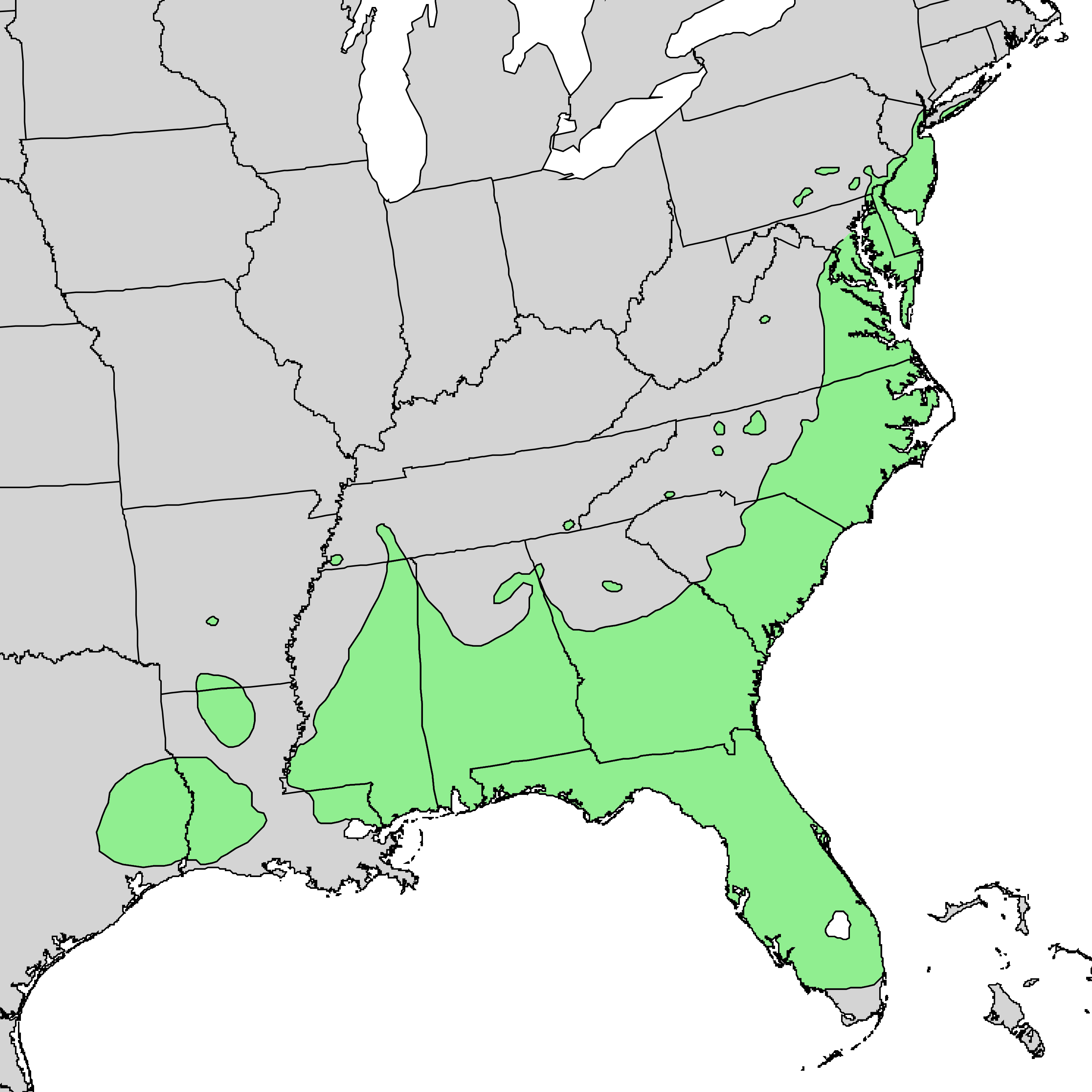
| คำอธิบายMagnolia virginiana range map 3.png |
English: Range map of Magnolia virginica |
| วันที่ | |
| แหล่งที่มา | Digital representation of "Atlas of United States Trees" by Elbert L. Little, Jr. [1] |
| ผู้สร้างสรรค์ | U.S. Geological Survey |
การอนุญาตใช้สิทธิ
| Public domainPublic domainfalsefalse |
This image is in the public domain in the United States because it only contains materials that originally came from the United States Geological Survey, an agency of the United States Department of the Interior. For more information, see the official USGS copyright policy.
Bahasa Indonesia ∙ català ∙ čeština ∙ Deutsch ∙ eesti ∙ English ∙ español ∙ français ∙ galego ∙ italiano ∙ Nederlands ∙ português ∙ polski ∙ sicilianu ∙ suomi ∙ Tiếng Việt ∙ Türkçe ∙ български ∙ македонски ∙ русский ∙ മലയാളം ∙ 한국어 ∙ 日本語 ∙ 中文 ∙ 中文(简体) ∙ 中文(繁體) ∙ العربية ∙ فارسی ∙ +/− |
ปูมการอัปโหลดต้นฉบับ
The original description page was here. All following user names refer to en.wikipedia.
- 2010-05-02 22:51 Masebrock 733×671× (124799 bytes) {{Information |Description=Range map of Magnolia virginica |Source=Digital representation of "Atlas of United States Trees" by Elbert L. Little, Jr. [http://esp.cr.usgs.gov/data/atlas/little/] |Date=1999 |Author=U.S. Geological Survey |Permission={{PD-USG
คำบรรยายโดยย่อ
เพิ่มคำบรรยายทรรทัดเดียวเพื่อขยายความว่าไฟล์นี้มีอะไร
รายการที่แสดงอยู่ในไฟล์นี้
ประกอบด้วย
ประวัติไฟล์
คลิกวันที่/เวลาเพื่อดูไฟล์ที่ปรากฏในขณะนั้น
| วันที่/เวลา | รูปย่อ | ขนาด | ผู้ใช้ | ความเห็น | |
|---|---|---|---|---|---|
| ปัจจุบัน | 22:54, 3 มกราคม 2557 | | 2,977 × 2,977 (164 กิโลไบต์) | Nonenmac | higher resolution |
| 10:16, 10 กันยายน 2554 |  | 1,200 × 1,200 (64 กิโลไบต์) | Nonenmac | Removed striping and changed to indexed color mode. | |
| 03:10, 8 สิงหาคม 2553 |  | 733 × 671 (122 กิโลไบต์) | GreenZmiy | {{Information |Description={{en|Range map of Magnolia virginica}} |Source=Transferred from [http://en.wikipedia.org en.wikipedia]<br/> (Original text : ''Digital representation of "Atlas of United States Trees" by Elbert L. Little, Jr. [http://esp.cr.usgs |
หน้าที่มีภาพนี้
หน้าต่อไปนี้ โยงมาที่ภาพนี้:
การใช้ไฟล์ข้ามโครงการ
วิกิอื่นต่อไปนี้ใช้ไฟล์นี้:
- การใช้บน ab.wikipedia.org
- การใช้บน ar.wikipedia.org
- การใช้บน arz.wikipedia.org
- การใช้บน azb.wikipedia.org
- การใช้บน ca.wikipedia.org
- การใช้บน ceb.wikipedia.org
- การใช้บน cs.wikipedia.org
- การใช้บน en.wikipedia.org
- การใช้บน es.wikipedia.org
- การใช้บน fa.wikipedia.org
- การใช้บน koi.wikipedia.org
- การใช้บน la.wikipedia.org
- การใช้บน nl.wikipedia.org
- การใช้บน no.wikipedia.org
- การใช้บน pl.wikipedia.org
- การใช้บน pt.wikipedia.org
- การใช้บน ru.wikipedia.org
- การใช้บน sv.wikipedia.org
- การใช้บน udm.wikipedia.org
- การใช้บน uk.wikipedia.org
- การใช้บน uz.wikipedia.org
- การใช้บน www.wikidata.org
ข้อมูลเกี่ยวกับภาพ
ภาพนี้มีข้อมูลเพิ่มเติม ซึ่งส่วนใหญ่มาจากกล้องดิจิตอลหรือสแกนเนอร์ที่สามารถเก็บข้อมูลดังกล่าวไว้รวมกับภาพได้ ถ้าภาพนี้ถูกปรับปรุงแก้ไขหรือเปลี่ยนแปลงจากเดิม ข้อมูลบางอย่างจะยังคงไม่เปลี่ยนแปลงเหมือนภาพที่ถูกปรับปรุงแก้ไขนั้น
| ความละเอียดแนวนอน | 472.44 dpc |
|---|---|
| ความละเอียดแนวตั้ง | 472.44 dpc |