ไฟล์:Han_foreign_relations_CE_2_chinese.jpg
From Wikipedia, the free encyclopedia
ดูภาพที่มีความละเอียดสูงกว่า (965 × 650 พิกเซล, ขนาดไฟล์: 530 กิโลไบต์, ชนิดไมม์: image/jpeg)
| รูปภาพหรือไฟล์เสียงนี้ ต้นฉบับอยู่ที่ คอมมอนส์ รายละเอียดด้านล่าง เป็นข้อความที่แสดงผลจาก ไฟล์ต้นฉบับในคอมมอนส์
|
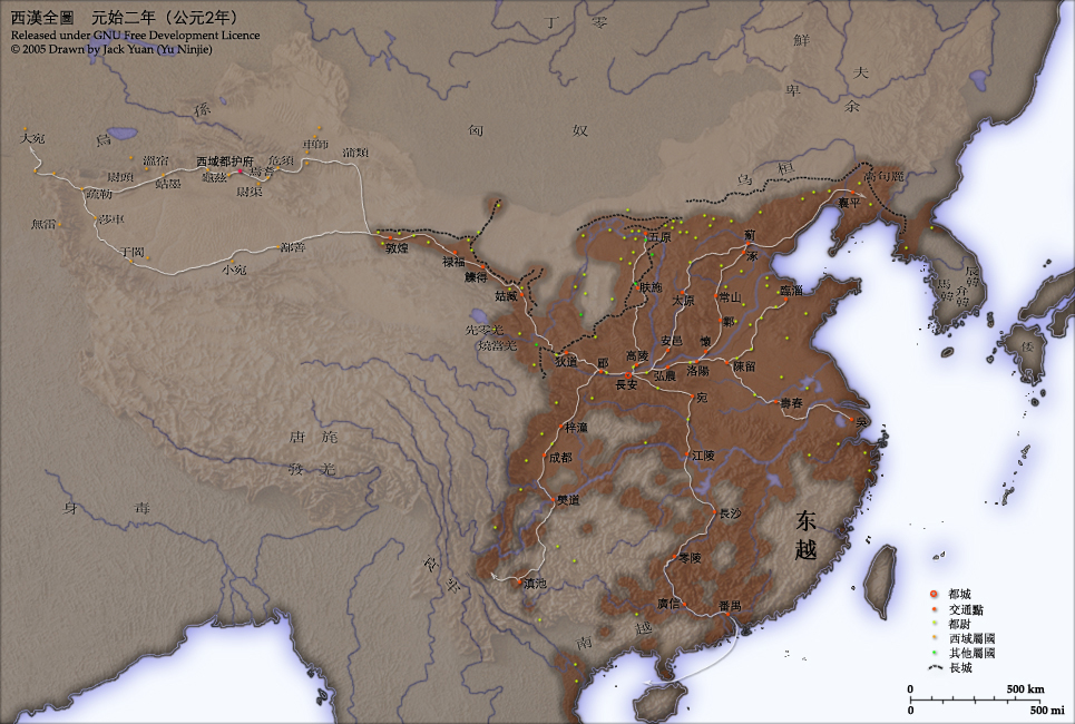
- Chinese language version of "Map of Han foreign relations in CE 2"
เนื้อหา
Introduction
This map shows the world as was known to Han Dynasty China in CE 2. Names of non-Chinese peoples and states have been purposely left with their Chinese names (e.g. Dayuan instead of Fergana; Gaogouli instead of Goguryeo) to reflect the fact that our knowledge of participants in the Han world order comes almost exclusively from Chinese sources.
- Credits
- Chinese Version of Image:Han foreign relations CE 2.jpg.
- Created and copyright (2005) by Yu Ninjie.
- Released under the GNU FDL.
Territorial garrisons
The headquarters of chief commandants (都尉) are shown in yellow. Chief commandants commanded territorial garrisons and were responsible for the supression of local armed threats and supervision of recruitment for military service. Note that these were concentrated on the frontiers, especially on the northern border region. When in the interior of the Han empire, they were often placed near iron or salt industries, or on important communication routes. A few dependent states (屬國) are shown in green. These were usually mixed settlements of Chinese and Xiongnu or more commonly, Qiang, under Han administration.
The Great Wall
During most of the Western Han period, the Great Wall served as a line of demarcation between Han and non-Chinese peoples, most notable of whom were the Xiongnu. The line of the Great Wall was extended by Emperor Wu along the Gansu corridor (the commanderies based at Dunhuang, Lufu, Lude and Guzang). This, along with walls north of the great loop of the Yellow River (beyond Wuyuan), provided the front line defences against the Xiongnu. A second line was maintained along the old Qin wall (the one that passes close to Fushi and Didao), which was important even into the 1st century CE.
Both the lines of the Great Wall and Yellow River are based on Tan Qixiang (ed.), Zhongguo lishi ditu (中国历史地图集), 1982. Note that the Yellow River is considerably to the north of its present flow.
Routes of communication
The broad outline of communication and transport routes from the capital Chang'an is marked in white. These were based on Qin Dynasty imperial highways, Han roads (such as the Chang'an-Anyi-Taiyuan-Yu road) and navigable riverways (such as the Chenliu and Shouchun river routes). The long road, often known as the Silk Road, extended west from Chang'an to the "Western Regions".
These are based in part on the reconstruction of early Chinese roads and waterways by Joseph Needham in Science and Civilisation, Vol. IV, 1954-, and the additions of Rafe de Crespigny in Generals of the South, 1992. The northern and southern routes of the Silk Road in the Western Regions is based on Map 16 in Cambridge History of China, vol. 1, 1986.
The Western Regions
From the end of the 2nd century CE, Han China fought with the Xiongnu over control of the "Western Regions". By the time that they established the office of Protector General of the Western Regions (at Wulei) in 60 BCE or 59 BCE, the entire region was dominated by the Chinese. Tributary city-states, in light orange, sent periodic tribute to Chang'an and were rewarded by the Han court.
License and Source

|
อนุญาตให้คัดลอก แจกจ่ายและ/หรือดัดแปรเอกสารนี้ภายใต้เงื่อนไขของสัญญาอนุญาตเอกสารเสรีของกนู รุ่น 1.2 หรือรุ่นใด ๆ นับจากนี้ที่ออกโดยมูลนิธิซอฟต์แวร์เสรี โดยไม่มีส่วนใดห้ามแก้ไข ไม่มีข้อความปกหน้าและปกหลัง สำเนาของสัญญาอนุญาตรวมอยู่ในส่วนชื่อ สัญญาอนุญาตเอกสารเสรีของกนูhttp://www.gnu.org/copyleft/fdl.htmlGFDLGNU Free Documentation Licensetruetrue |
| ไฟล์นี้อยู่ภายใต้สัญญาอนุญาต ครีเอทีฟคอมมอนส์ แบบแสดงที่มา-อนุญาตแบบเดียวกัน 3.0 ต้นฉบับ | ||
| ||
| ป้ายแสดงสถานะลิขสิทธิ์นี้ถูกเพิ่มเพื่อให้เป็นไปตามการเปลี่ยนแปลงสัญญาอนุญาตของมูลนิธิวิกิมีเดีย จาก GFDL ไปยัง GFDL ควบคู่กับ CC-BY-SA 3.0http://creativecommons.org/licenses/by-sa/3.0/CC BY-SA 3.0Creative Commons Attribution-Share Alike 3.0truetrue |
- Source
- Chinese Wikipedia, original upload 2005年4月7日 (木) by Yu Ninjie
คำบรรยายโดยย่อ
ไอเทมที่แสดงอยู่ในไฟล์นี้
ประกอบด้วย
ประวัติไฟล์
คลิกวันที่/เวลาเพื่อดูไฟล์ที่ปรากฏในขณะนั้น
| วันที่/เวลา | รูปย่อ | ขนาด | ผู้ใช้ | ความเห็น | |
|---|---|---|---|---|---|
| ปัจจุบัน | 10:37, 25 มิถุนายน 2552 | | 965 × 650 (530 กิโลไบต์) | KEIMS | add a name |
| 16:29, 13 ธันวาคม 2548 |  | 965 × 650 (516 กิโลไบต์) | Shizhao | ||
| 09:51, 4 ตุลาคม 2548 |  | 965 × 650 (558 กิโลไบต์) | Saperaud~commonswiki | Chinese Version of Image:Han foreign relations CE 2.jpg. Created and copyright (2005) by Yu Ninjie. Released under the GNU FDL. This map shows the world as was known to Han Dynasty China |
หน้าที่มีภาพนี้
หน้าต่อไปนี้ โยงมาที่ภาพนี้:
การใช้ไฟล์ข้ามโครงการ
วิกิอื่นต่อไปนี้ใช้ไฟล์นี้:
- การใช้บน av.wikipedia.org
- การใช้บน azb.wikipedia.org
- การใช้บน incubator.wikimedia.org
- การใช้บน ja.wikipedia.org
- การใช้บน rue.wikipedia.org
- การใช้บน ru.wikipedia.org
- การใช้บน wikimania2006.wikimedia.org
- การใช้บน yi.wikipedia.org
- การใช้บน zh-classical.wikipedia.org
- การใช้บน zh-min-nan.wikipedia.org
- การใช้บน zh.wikipedia.org
ข้อมูลเกี่ยวกับภาพ
ภาพนี้มีข้อมูลเพิ่มเติม ซึ่งส่วนใหญ่มาจากกล้องดิจิตอลหรือสแกนเนอร์ที่สามารถเก็บข้อมูลดังกล่าวไว้รวมกับภาพได้ ถ้าภาพนี้ถูกปรับปรุงแก้ไขหรือเปลี่ยนแปลงจากเดิม ข้อมูลบางอย่างจะยังคงไม่เปลี่ยนแปลงเหมือนภาพที่ถูกปรับปรุงแก้ไขนั้น
| การจัดวางภาพ | ปกติ |
|---|---|
| ความละเอียดแนวนอน | 150 dpi |
| ความละเอียดแนวตั้ง | 150 dpi |
| ซอฟต์แวร์ที่ใช้ | Adobe Photoshop CS2 Windows |
| แก้ไขภาพล่าสุด | 23:36, 24 มิถุนายน 2552 |
| สเปซสี | sRGB |
| ความกว้างของภาพ | 965 พิกเซล |
| ความสูงของภาพ | 650 พิกเซล |
| เวลาที่แปลงเป็นดิจิทัล | 22:58, 7 เมษายน 2548 |
| วันที่แก้ไขข้อมูลเมตาล่าสุด | 19:36, 24 มิถุนายน 2552 |
| รุ่น IIM | 2 |