ไฟล์:Cuban_crisis_map_missile_range.jpg
From Wikipedia, the free encyclopedia
ขนาดของตัวอย่างนี้: 603 × 599 พิกเซล ความละเอียดอื่น: 241 × 240 พิกเซล | 483 × 480 พิกเซล | 666 × 662 พิกเซล
ดูภาพที่มีความละเอียดสูงกว่า (666 × 662 พิกเซล, ขนาดไฟล์: 198 กิโลไบต์, ชนิดไมม์: image/jpeg)
| รูปภาพหรือไฟล์เสียงนี้ ต้นฉบับอยู่ที่ คอมมอนส์ รายละเอียดด้านล่าง เป็นข้อความที่แสดงผลจาก ไฟล์ต้นฉบับในคอมมอนส์
|

|
This file has been superseded by The relative ranges of the IL-28, SS-4, and SS-5, stationed on Cuba.png. It is recommended to use the other file. Please note that deleting superseded images requires consent. Reason to use the other file: "A PNG version of this file is now available."
|

|
| คำอธิบายCuban crisis map missile range.jpg |
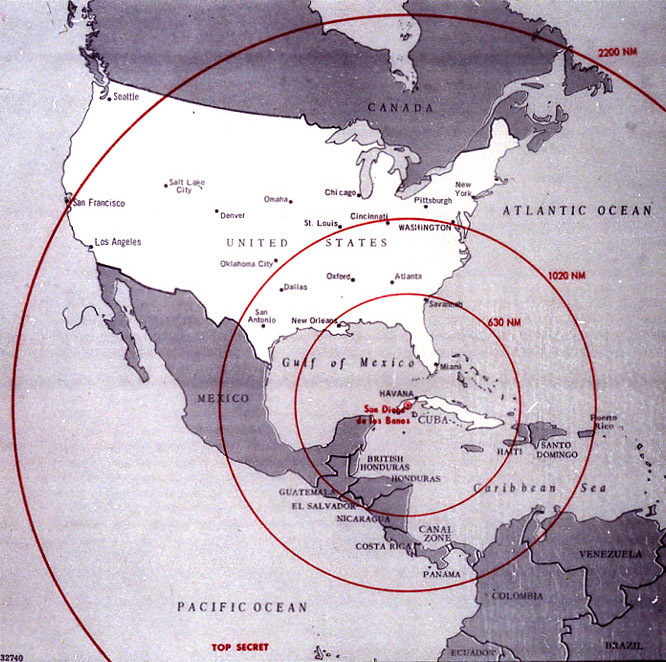
English: Map of Northern America showing the full range of the nuclear missiles under construction in Cuba, used during the secret meetings on the Cuban crisis. Deutsch: Diese Karte der westlichen Hemisphäre zeigt die volle Reichweite der Atomraketen, die auf Kuba im Rahmen der Kubakrise stationiert werden sollten bzw. worden sind. Diese Karte wurde bei den geheimen Treffen während der Kubakrise verwendet. Die Karte war ehemals Top Secret. Die eingezeichneten Radien sind in Nautischen Meilen (1 NM ~ 1,852 km) bemaßt; die 1020 NM (~ 1900 km) entsprechen ungefähr der taktischen Reichweite der SS-4, die 2200 NM (~ 4000 km) jener der SS-5. |
||||
| วันที่ | |||||
| แหล่งที่มา | The John F. Kennedy Presidential Library and Museum, Boston. [1] | ||||
| ผู้สร้างสรรค์ | CIA | ||||
| การอนุญาต (การใช้ไฟล์นี้ใหม่) |
|

คำบรรยายโดยย่อ
เพิ่มคำบรรยายทรรทัดเดียวเพื่อขยายความว่าไฟล์นี้มีอะไร
Map showing the maximum range of Soviet missiles deployed in Cuba in 1962
Mapa que muestra el alcance máximo de los misiles soviéticos desplegados en Cuba en 1962
raggio d'azione potenziale dei missili sovietici installati a Cuba
รายการที่แสดงอยู่ในไฟล์นี้
ประกอบด้วย
16 ตุลาคม 1962
media type อังกฤษ
image/jpeg
checksum อังกฤษ
89a2dee262749dfc22abebb6d457e36d8b7f96d9
data size อังกฤษ
202,362 ไบต์
662 พิกเซล
666 พิกเซล
ประวัติไฟล์
คลิกวันที่/เวลาเพื่อดูไฟล์ที่ปรากฏในขณะนั้น
| วันที่/เวลา | รูปย่อ | ขนาด | ผู้ใช้ | ความเห็น | |
|---|---|---|---|---|---|
| ปัจจุบัน | 04:18, 9 มกราคม 2552 | | 666 × 662 (198 กิโลไบต์) | PaulBommel | {{Information |Description= |Source= |Date= |Author= |Permission= |other_versions= }} |
| 23:31, 9 มิถุนายน 2550 |  | 700 × 920 (249 กิโลไบต์) | Nickel Chromo~commonswiki | {{Information| |Description= '''English''': Map of the western hemisphere showing the full range of the nuclear missiles under construction in Cuba, used during the secret meetings on the Cuban crisis. |Source= The John F. Kennedy Presidential Library and |
หน้าที่มีภาพนี้
หน้าต่อไปนี้ โยงมาที่ภาพนี้:
การใช้ไฟล์ข้ามโครงการ
วิกิอื่นต่อไปนี้ใช้ไฟล์นี้:
- การใช้บน ar.wikipedia.org
- การใช้บน ba.wikipedia.org
- การใช้บน bg.wikipedia.org
- การใช้บน da.wikipedia.org
- การใช้บน en.wikipedia.org
- การใช้บน en.wikiquote.org
- การใช้บน eo.wikipedia.org
- การใช้บน es.wikipedia.org
- การใช้บน fi.wikipedia.org
- การใช้บน fi.wikibooks.org
- การใช้บน ga.wikipedia.org
- การใช้บน hr.wikipedia.org
- การใช้บน it.wikipedia.org
- การใช้บน lv.wikipedia.org
- การใช้บน no.wikibooks.org
- การใช้บน rm.wikipedia.org
- การใช้บน ro.wikipedia.org
- การใช้บน ru.wikipedia.org
- การใช้บน sk.wikipedia.org
- การใช้บน sr.wikipedia.org
- การใช้บน sv.wikipedia.org
- การใช้บน uk.wikipedia.org
ข้อมูลเกี่ยวกับภาพ
ภาพนี้มีข้อมูลเพิ่มเติม ซึ่งส่วนใหญ่มาจากกล้องดิจิตอลหรือสแกนเนอร์ที่สามารถเก็บข้อมูลดังกล่าวไว้รวมกับภาพได้ ถ้าภาพนี้ถูกปรับปรุงแก้ไขหรือเปลี่ยนแปลงจากเดิม ข้อมูลบางอย่างจะยังคงไม่เปลี่ยนแปลงเหมือนภาพที่ถูกปรับปรุงแก้ไขนั้น
| _error | 0 |
|---|