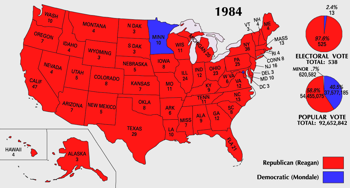
File:ElectoralCollege1984-Large.png
From Wikipedia, the free encyclopedia
ขนาดของตัวอย่างนี้: 800 × 430 พิกเซล ความละเอียดอื่น: 320 × 172 พิกเซล | 640 × 344 พิกเซล | 1,182 × 635 พิกเซล
ดูภาพที่มีความละเอียดสูงกว่า (1,182 × 635 พิกเซล, ขนาดไฟล์: 163 กิโลไบต์, ชนิดไมม์: image/png)
| รูปภาพหรือไฟล์เสียงนี้ ต้นฉบับอยู่ที่ คอมมอนส์ รายละเอียดด้านล่าง เป็นข้อความที่แสดงผลจาก ไฟล์ต้นฉบับในคอมมอนส์
|
| U.S. presidential election maps from the National Atlas of the United States |
| See also: SVG maps |
| 1789 · 1792 · 1796 · 1800 · 1804 · 1808 · 1812 · 1816 · 1820 · 1824 · 1828 · 1832 · 1836 · 1840 · 1844 · 1848 · 1852 · 1856 · 1860 · 1864 · 1868 · 1872 · 1876 · 1880 · 1884 · 1888 · 1892 · 1896 · 1900 · 1904 · 1908 · 1912 · 1916 · 1920 · 1924 · 1928 · 1932 · 1936 · 1940 · 1944 · 1948 · 1952 · 1956 · 1960 · 1964 · 1968 · 1972 · 1976 · 1980 · 1984 · 1988 · 1992 · 1996 · 2000 · 2004 |
ความย่อ


การอนุญาตใช้สิทธิ
| Public domainPublic domainfalsefalse |
This map was obtained from an edition of the National Atlas of the United States. Like almost all works of the U.S. federal government, works from the National Atlas are in the public domain in the United States.
Online access: NationalAtlas.gov | 1970 print edition: Library of Congress, Perry-Castañeda Library čeština | Deutsch | English | français | Bahasa Indonesia | italiano | македонски | മലയാളം | sicilianu | 中文 | 中文(简体) | 中文(繁體) | +/− |
ประวัติไฟล์
คลิกวันที่/เวลาเพื่อดูไฟล์ที่ปรากฏในขณะนั้น
| วันที่/เวลา | รูปย่อ | ขนาด | ผู้ใช้ | ความเห็น | |
|---|---|---|---|---|---|
| ปัจจุบัน | 17:20, 25 กรกฎาคม 2550 | | 1,182 × 635 (163 กิโลไบต์) | Cardsplayer4life~commonswiki | Reverted to earlier revision |
| 16:32, 25 กรกฎาคม 2550 |  | 1,182 × 635 (104 กิโลไบต์) | Joseph Solis in Australia~commonswiki | {{PD-USGov-Atlas}} Category:1988 {{US presidential election maps}} | |
| 08:46, 9 กรกฎาคม 2550 |  | 1,182 × 635 (163 กิโลไบต์) | Cardsplayer4life~commonswiki | {{PD-USGov-Atlas}} Category:1984 {{US presidential election maps}} | |
| 16:36, 6 กรกฎาคม 2550 |  | 1,182 × 635 (104 กิโลไบต์) | Joseph Solis in Australia~commonswiki | {{PD-USGov-Atlas}} Category:1984 {{US presidential election maps}} | |
| 09:28, 2 กรกฎาคม 2550 |  | 1,182 × 635 (163 กิโลไบต์) | Cardsplayer4life~commonswiki | {{PD-USGov-Atlas}} Category:1984 {{US presidential election maps}} | |
| 17:14, 29 มิถุนายน 2550 |  | 1,182 × 635 (104 กิโลไบต์) | Joseph Solis in Australia~commonswiki | {{PD-USGov-Atlas}} Category:1984 {{US presidential election maps}} | |
| 04:07, 22 มิถุนายน 2550 |  | 1,182 × 635 (163 กิโลไบต์) | Cardsplayer4life~commonswiki | {{PD-USGov-Atlas}} Category:1984 {{US presidential election maps}} | |
| 15:27, 31 พฤษภาคม 2550 |  | 1,182 × 635 (104 กิโลไบต์) | Joseph Solis in Australia~commonswiki | {{PD-USGov-Atlas}} Category:1984 {{US presidential election maps}} | |
| 03:06, 26 พฤษภาคม 2549 |  | 1,182 × 635 (89 กิโลไบต์) | JP06035 | switched colors | |
| 23:08, 22 มกราคม 2549 |  | 1,182 × 635 (104 กิโลไบต์) | Red devil 666 | {{PD-USGov-Atlas}} |
หน้าที่มีภาพนี้
ไม่มีหน้าใดโยงมาที่ภาพนี้
การใช้ไฟล์ข้ามโครงการ
วิกิอื่นต่อไปนี้ใช้ไฟล์นี้:
- การใช้บน hu.wikipedia.org
ข้อมูลเกี่ยวกับภาพ
ภาพนี้มีข้อมูลเพิ่มเติม ซึ่งส่วนใหญ่มาจากกล้องดิจิตอลหรือสแกนเนอร์ที่สามารถเก็บข้อมูลดังกล่าวไว้รวมกับภาพได้ ถ้าภาพนี้ถูกปรับปรุงแก้ไขหรือเปลี่ยนแปลงจากเดิม ข้อมูลบางอย่างจะยังคงไม่เปลี่ยนแปลงเหมือนภาพที่ถูกปรับปรุงแก้ไขนั้น
| ความละเอียดแนวนอน | 28.35 dpc |
|---|---|
| ความละเอียดแนวตั้ง | 28.35 dpc |