File:1856_Electoral_Map.png
From Wikipedia, the free encyclopedia
ขนาดของตัวอย่างนี้: 800 × 430 พิกเซล ความละเอียดอื่น: 320 × 172 พิกเซล | 640 × 344 พิกเซล | 1,182 × 635 พิกเซล
ดูภาพที่มีความละเอียดสูงกว่า (1,182 × 635 พิกเซล, ขนาดไฟล์: 165 กิโลไบต์, ชนิดไมม์: image/png)
| รูปภาพหรือไฟล์เสียงนี้ ต้นฉบับอยู่ที่ คอมมอนส์ รายละเอียดด้านล่าง เป็นข้อความที่แสดงผลจาก ไฟล์ต้นฉบับในคอมมอนส์
|
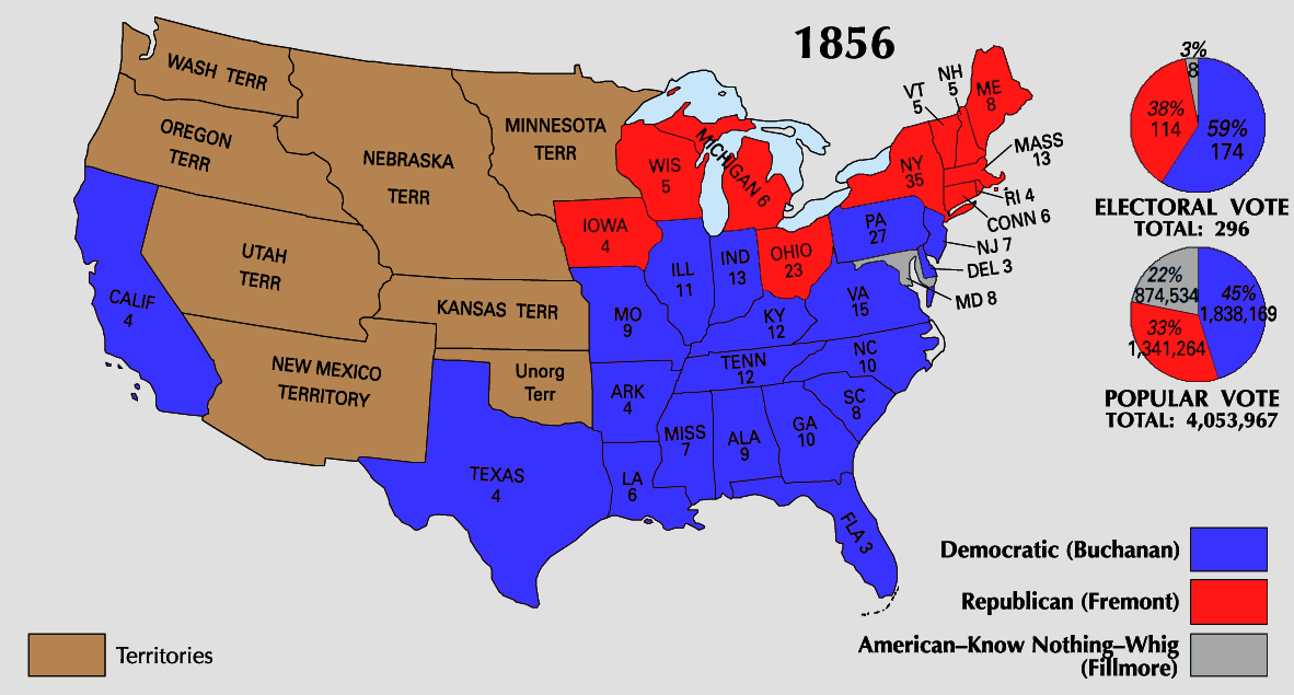
| U.S. presidential election maps from the National Atlas of the United States |
| See also: SVG maps |
| 1789 · 1792 · 1796 · 1800 · 1804 · 1808 · 1812 · 1816 · 1820 · 1824 · 1828 · 1832 · 1836 · 1840 · 1844 · 1848 · 1852 · 1856 · 1860 · 1864 · 1868 · 1872 · 1876 · 1880 · 1884 · 1888 · 1892 · 1896 · 1900 · 1904 · 1908 · 1912 · 1916 · 1920 · 1924 · 1928 · 1932 · 1936 · 1940 · 1944 · 1948 · 1952 · 1956 · 1960 · 1964 · 1968 · 1972 · 1976 · 1980 · 1984 · 1988 · 1992 · 1996 · 2000 · 2004 |
ความย่อ
| คำอธิบาย1856 Electoral Map.png |
ภาพหรือสื่อนี้ขาดคำอธิบายภาพหรือสื่อ และอาจขาดข้อมูลอื่น ๆ ด้วย
กรุณาช่วยเพิ่มคำอธิบายที่มีความหมายชัดเจนลงบนภาพหรือสื่อนี้ |
| แหล่งที่มา | https://nationalmap.gov/small_scale/printable/elections.html |
| ผู้สร้างสรรค์ | United States Geological Survey |
การอนุญาตใช้สิทธิ
| Public domainPublic domainfalsefalse |
This map was obtained from an edition of the National Atlas of the United States. Like almost all works of the U.S. federal government, works from the National Atlas are in the public domain in the United States.
Online access: NationalAtlas.gov | 1970 print edition: Library of Congress, Perry-Castañeda Library čeština | Deutsch | English | français | Bahasa Indonesia | italiano | македонски | മലയാളം | sicilianu | 中文 | 中文(简体) | 中文(繁體) | +/− |
คำบรรยายโดยย่อ
เพิ่มคำบรรยายทรรทัดเดียวเพื่อขยายความว่าไฟล์นี้มีอะไร
รายการที่แสดงอยู่ในไฟล์นี้
ประกอบด้วย
media type อังกฤษ
image/png
checksum อังกฤษ
58ea9f78819ee43287cf9bad36d1389b7b28700b
data size อังกฤษ
169,179 ไบต์
635 พิกเซล
1,182 พิกเซล
ประวัติไฟล์
คลิกวันที่/เวลาเพื่อดูไฟล์ที่ปรากฏในขณะนั้น
| วันที่/เวลา | รูปย่อ | ขนาด | ผู้ใช้ | ความเห็น | |
|---|---|---|---|---|---|
| ปัจจุบัน | 06:08, 26 มิถุนายน 2551 | | 1,182 × 635 (165 กิโลไบต์) | Tallicfan20 | {{Information |Description= |Source= |Date= |Author= |Permission= |other_versions= }} |
| 11:09, 25 พฤษภาคม 2551 |  | 1,182 × 635 (153 กิโลไบต์) | Tallicfan20 | better coloring | |
| 12:00, 17 พฤษภาคม 2551 |  | 1,182 × 635 (96 กิโลไบต์) | Tallicfan20 | {{PD-USGov-Atlas}} |
หน้าที่มีภาพนี้
ไม่มีหน้าใดโยงมาที่ภาพนี้
การใช้ไฟล์ข้ามโครงการ
วิกิอื่นต่อไปนี้ใช้ไฟล์นี้:
- การใช้บน it.wikipedia.org
- การใช้บน no.wikipedia.org
- การใช้บน sv.wikipedia.org
ข้อมูลเกี่ยวกับภาพ
ภาพนี้มีข้อมูลเพิ่มเติม ซึ่งส่วนใหญ่มาจากกล้องดิจิตอลหรือสแกนเนอร์ที่สามารถเก็บข้อมูลดังกล่าวไว้รวมกับภาพได้ ถ้าภาพนี้ถูกปรับปรุงแก้ไขหรือเปลี่ยนแปลงจากเดิม ข้อมูลบางอย่างจะยังคงไม่เปลี่ยนแปลงเหมือนภาพที่ถูกปรับปรุงแก้ไขนั้น
| ความละเอียดแนวนอน | 37.79 dpc |
|---|---|
| ความละเอียดแนวตั้ง | 37.79 dpc |