File:Map_Crusader_states_1135-el.svg
From Wikipedia, the free encyclopedia

Ҳаҷми пешнамоиши PNG барои файли кунунии SVG: 441 × 600 пиксел. Дигар кайфиятҳо: 176 × 240 пиксел | 353 × 480 пиксел | 565 × 768 пиксел | 753 × 1 024 пиксел | 1 506 × 2 048 пиксел | 978 × 1 330 пиксел.
Акси аслӣ (SVG парванда, исмӣ 978 × 1 330 пиксел, андозаи парванда: 490 кбайт)
Ин файл аз Викианбор ва дар дигар лоиҳаҳо метавонад истифода шавад. Тафсилоти ин файл саҳифаи тафсилоти файл дар зер нишон дода шудааст.
Хулоса
| ТавсифотMap Crusader states 1135-el.svg |
[вироиш]
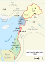
Čeština: Politická mapa Blízkého východu v roce 1135. Deutsch: Die Levante, 1135, zwischen den Ersten und Zweiten Kreuzzügen. Kreuzzugsstaaten sind mit einem roten Kreuz gekennzeichnet Eesti: Lähis-Ida (1135) Español: Oriente Próximo en 1135, entre la primera y segunda cruzadas. Esperanto: Politika mapo de Levantenio dum 1135, inter la krucmilitaroj unuaj kaj duaj. Français : Carte politique du Proche-Orient en 1135, entre la Première et la Seconde Croisades. les États latins d'Orient sont marqués d'une croix rouge. Galego: Mapa dos estados cruzados en Próximo Oriente polo 1135. Italiano: Carta politica del Vicino Oriente nel 1135. Magyar: A Közel-Kelet térképe 1135-ben. Polski: Mapa polityczna Bliskiego Wschodu w roku 1135, w okresie II krucjaty. Ελληνικά: Πολιτικός χάρτης της Μέσης Ανατολής το 1135, ανάμεσα στην πρώτη και τη δεύτερη Σταυροφορία Македонски: Политичка карта на Блискиот Исток во 1135 г. Крстоносните држави се означени со црвени крстови. Русский: Карта Ближнего Востока в 1135 г. Српски / srpski: Politička karta Bliskog Istoka 1135. godine, između Prvog i Drugog krstaškog pohoda. Krstaške države su označene crvenim krstom. ქართული: ახლო აღმოსავლეთი 1135 წელს ไทย: แผนที่ตะวันออกกลาง (คศ. 1135) ระหว่างครูเสดครั้งที่ 1 และครั่งที่ 2 中文: 一副关于1135年近东地区局势的地图,标注红色十字的为十字军国家 العربية : الدويلات الصليبية والدول الإسلامية المجاورة لها في الفترة بين الحملتين الصليبيتين الأولى والثانية. فارسی : نسخه فارسی No description.
|
||||||||||||||
| Манбаъ | Кори худ | ||||||||||||||
| Муаллиф | MapMaster | ||||||||||||||
References
- Bjorklund, Oddvar; Holmboe, Haakon; Rohr, Anders (1970) Historical Atlas of the World, Barnes & Noble, NY, SBN: 389-00253-4.
- Asia Minor and the Crusader states, c. 1140 from Findlay, Alexander G. (1849) Classical Atlas of Ancient Geography.
- Map of the Crusader states from Muir's Historical Atlas (1911)
- Eine Karte aus Putzgers, Historischer Schul-Atlas 39. Auflage. 1917. Tafel 16.
Other versions
|other_versions=[вироиш]
-
 العربية
 -
 català
 -
 čeština (чехӣ)
 -
 Deutsch (немисӣ)
 -
 English (Англисӣ) (original)
 -
 Esperanto (эсперанто)
 -
 español (испанӣ) (1)
 -
 español (испанӣ) (2)
 -
 eesti (эстонӣ) (PNG)
 -
 français (франсузӣ) (1)
 -
 français (франсузӣ) (2)
 -
 galego (галисиягӣ) (1)
 -
 Bahasa Indonesia
 -
 italiano (италиявӣ) (PNG)
 -
 magyar (маҷорӣ)
 -
 日本語 (японӣ) (PNG)
 -
 Nederlands (голландӣ)
 -
 polski (лаҳистонӣ)
 -
 português (португалӣ)
 -
 македонски (мақдунӣ)
 -
 русский (русӣ)
 -
 Ελληνικά (юнонӣ)
 -
 հայերեն (арманӣ)
 -
 ქართული (гурҷӣ) (PNG)
 -
 中文 (хитоӣ)
 -
 العربية (арабӣ) (PNG)
 -
 فارسی (форсӣ) (PNG)


-ka.png)


See also
Иҷозатнома
I, the copyright holder of this work, hereby publish it under the following licenses:

|
Permission is granted to copy, distribute and/or modify this document under the terms of the GNU Free Documentation License, Version 1.2 or any later version published by the Free Software Foundation; with no Invariant Sections, no Front-Cover Texts, and no Back-Cover Texts. A copy of the license is included in the section entitled GNU Free Documentation License.http://www.gnu.org/copyleft/fdl.htmlGFDLGNU Free Documentation Licensetruetrue |
| This file is licensed under the Creative Commons Attribution-Share Alike 3.0 Unported license. | ||
| ||
| This licensing tag was added to this file as part of the GFDL licensing update.http://creativecommons.org/licenses/by-sa/3.0/CC BY-SA 3.0Creative Commons Attribution-Share Alike 3.0truetrue |
This file is licensed under the Creative Commons Attribution-Share Alike 2.5 Generic license.
- Шумо озодед:
- мубодилот намудан – копӣ, паҳн ва фиристадани асар
- ремикс кардан – татбиқи кор
- Under the following conditions:
- тахсис – You must give appropriate credit, provide a link to the license, and indicate if changes were made. You may do so in any reasonable manner, but not in any way that suggests the licensor endorses you or your use.
- саҳми яксон – If you remix, transform, or build upon the material, you must distribute your contributions under the same or compatible license as the original.
Шумо иҷозатномаи хостаи худро интихоб карда метавонед.
Captions
Add a one-line explanation of what this file represents
Items portrayed in this file
тавсифҳо
some value
copyrighted Англисӣ
source of file Англисӣ
original creation by uploader Англисӣ
Таърихи файл
Рӯи таърихҳо клик кунед то нусхаи марбути парвандаро бубинед.
| Таърих | Бандангуштӣ | Андоза | Корбар | Тавзеҳ | |
|---|---|---|---|---|---|
| нусхаи феълӣ | 02:39, 4 июни 2008 | | 978 × 1 330 (490 кбайт) | MapMaster | trying to fix rendering |
| 02:30, 4 июни 2008 |  | 978 × 1 330 (378 кбайт) | MapMaster | corrected 4 labels | |
| 14:01, 27 феврали 2008 |  | 978 × 1 330 (493 кбайт) | MapMaster | trying to fix what went wrong last time | |
| 03:08, 27 феврали 2008 |  | 978 × 1 330 (379 кбайт) | MapMaster | fixed word spacing | |
| 01:34, 6 октябри 2007 |  | 978 × 1 330 (374 кбайт) | MapMaster | == Summary == {{de|Die Levante, 1135, zwischen den Ersten und Zweiten Kreuzzügen.}} {{en|A political map of the w:en:Near East in 1135 CE.}} {{fr|Carte politique du Proche-Orient en 1135, en |
Пайвандҳо
Ин акс дар ҳеҷ саҳифа истифода намешавад.
Истифодаи саросарии парванда
Викиҳои дигари зерин ин файлро истифода мекунанд:
- Истифода дар el.wikipedia.org