File:Kazakhstan_provinces_numbered_english.png
From Wikipedia, the free encyclopedia
Нусхаи ҳаҷман ва сифатан баландтар дастрас нест.
Kazakhstan_provinces_numbered_english.png ((500 × 285 пиксел, ҳаҷми парванда: 14 кбайт, навъи MIME: image/png))
Ин файл аз Викианбор ва дар дигар лоиҳаҳо метавонад истифода шавад. Тафсилоти ин файл саҳифаи тафсилоти файл дар зер нишон дода шудааст.
Хулоса
| ТавсифотKazakhstan provinces numbered english.png |
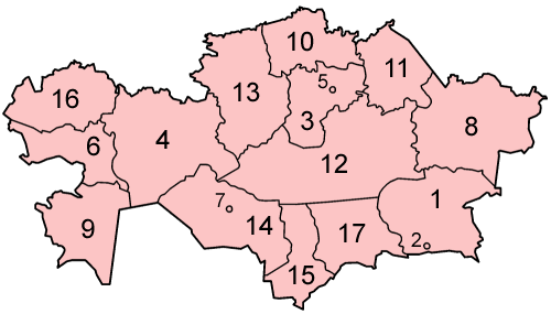
Map of the provinces of Kazakhstan in alphabetical order in English. Made by User:Golbez based on a PD United Nations map; its borders are different from the available CIA maps, but the UN map is several years newer. |
| Сана | 6 Январ 2006 (original upload date) |
| Манбаъ | No machine-readable source provided. Own work assumed (based on copyright claims). |
| Муаллиф | No machine-readable author provided. Golbez assumed (based on copyright claims). |
Иҷозатнома
I, the copyright holder of this work, hereby publish it under the following licenses:

|
Permission is granted to copy, distribute and/or modify this document under the terms of the GNU Free Documentation License, Version 1.2 or any later version published by the Free Software Foundation; with no Invariant Sections, no Front-Cover Texts, and no Back-Cover Texts. A copy of the license is included in the section entitled GNU Free Documentation License.http://www.gnu.org/copyleft/fdl.htmlGFDLGNU Free Documentation Licensetruetrue |
| This file is licensed under the Creative Commons Attribution-Share Alike 3.0 Unported license. | ||
| ||
| This licensing tag was added to this file as part of the GFDL licensing update.http://creativecommons.org/licenses/by-sa/3.0/CC BY-SA 3.0Creative Commons Attribution-Share Alike 3.0truetrue |
This file is licensed under the Creative Commons Attribution 2.5 Generic license.
- Шумо озодед:
- мубодилот намудан – копӣ, паҳн ва фиристадани асар
- ремикс кардан – татбиқи кор
- Under the following conditions:
- тахсис – You must give appropriate credit, provide a link to the license, and indicate if changes were made. You may do so in any reasonable manner, but not in any way that suggests the licensor endorses you or your use.
Шумо иҷозатномаи хостаи худро интихоб карда метавонед.
Captions
Add a one-line explanation of what this file represents
Items portrayed in this file
тавсифҳо
copyrighted Англисӣ
6 Январ 2006
Таърихи файл
Рӯи таърихҳо клик кунед то нусхаи марбути парвандаро бубинед.
| Таърих | Бандангуштӣ | Андоза | Корбар | Тавзеҳ | |
|---|---|---|---|---|---|
| нусхаи феълӣ | 05:32, 6 Январ 2006 | | 500 × 285 (14 кбайт) | Golbez | Map of the provinces of Kazakhstan in alphabetical order in English. Made by User:Golbez based on a PD United Nations map; its borders are different from the available CIA maps, but the UN map is several years newer. Category:Maps of Kazakhstan |
Пайвандҳо
Саҳифаҳои зерин ба ин акс пайванданд:
Истифодаи саросарии парванда
Викиҳои дигари зерин ин файлро истифода мекунанд:
- Истифода дар ca.wikipedia.org
- Истифода дар en.wikipedia.org
- Истифода дар eu.wikipedia.org
- Истифода дар fi.wikipedia.org
- Истифода дар gl.wikipedia.org
- Истифода дар nl.wikipedia.org
- Истифода дар pt.wikipedia.org
- Истифода дар sv.wikipedia.org
- Истифода дар wuu.wikipedia.org