File:Gps-atmosphericefects.xcf
From Wikipedia, the free encyclopedia

Ҳаҷми пешнамоиши PNG барои файли кунунии XCF: 608 × 599 пиксел. Дигар кайфиятҳо: 243 × 240 пиксел | 487 × 480 пиксел | 849 × 837 пиксел.
Акси аслӣ ((849 × 837 пиксел, ҳаҷми парванда: 539 кбайт, навъи MIME: image/x-xcf))
Ин файл аз Викианбор ва дар дигар лоиҳаҳо метавонад истифода шавад. Тафсилоти ин файл саҳифаи тафсилоти файл дар зер нишон дода шудааст.
|
|
| ТавсифотGps-atmosphericefects.xcf |
Español: Efecto de la atmósfera en la propagación de la señal GPS.
English: Effect of the atmosphere in the GPS signal propagation. |
| Сана | (UTC) |
| Манбаъ | |
| Муаллиф |
|
| Other versions |
| This is a retouched picture, which means that it has been digitally altered from its original version. Modifications: Collage. The original can be viewed here: GPS tracking satellites.jpg:
|
This file is licensed under the Creative Commons Attribution-Share Alike 3.0 Unported license.
- Шумо озодед:
- мубодилот намудан – копӣ, паҳн ва фиристадани асар
- ремикс кардан – татбиқи кор
- Under the following conditions:
- тахсис – You must give appropriate credit, provide a link to the license, and indicate if changes were made. You may do so in any reasonable manner, but not in any way that suggests the licensor endorses you or your use.
- саҳми яксон – If you remix, transform, or build upon the material, you must distribute your contributions under the same or compatible license as the original.
Original upload log
This image is a derivative work of the following images:
- File:The_Earth_seen_from_Apollo_17.jpg licensed with PD-USGov-NASA
- 2004-11-08T15:18:10Z Ævar Arnfjörð Bjarmason 1860x1898 (5274108 Bytes)
- File:Navstar-2.jpg licensed with PD-USGov-Military-Air Force
- 2005-03-26T18:06:36Z GDK 400x400 (20897 Bytes) NAVSTAR-2 (GPS-2) satellite Source: http://www.jpl.nasa.gov/images/grace/grace_083002_browse.jpg Status: PD-USGov-Military-Air Force {{PD-USGov-Military-Air Force}} [[Category:Satellites]]
- File:GPS_tracking_satellites.jpg licensed with Cc-by-sa-2.5,2.0,1.0, Cc-by-sa-3.0-migrated, GFDL
- 2007-04-21T06:19:59Z Theonlysilentbob 1536x2048 (385521 Bytes) == Summary == {{Information |Description = Garmin eTrex Yellow GPS acquiring satellite signal |Source = Not Applicable |Date = April 21st 2007 |Author = Vaughan Weather |Permission = Anyone can use and freely distribute this
Uploaded with derivativeFX
Captions
Add a one-line explanation of what this file represents
Items portrayed in this file
тавсифҳо
copyrighted Англисӣ
9 апрели 2010
Таърихи файл
Рӯи таърихҳо клик кунед то нусхаи марбути парвандаро бубинед.
| Таърих | Бандангуштӣ | Андоза | Корбар | Тавзеҳ | |
|---|---|---|---|---|---|
| нусхаи феълӣ | 14:10, 9 апрели 2010 | 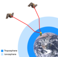 | 849 × 837 (539 кбайт) | Javiersanp | {{Information |Description={{en|1=aaa}} |Source={{own}} |Author=Javiersanp |Date= |Permission= |other_versions= }} |
Пайвандҳо
Ин акс дар ҳеҷ саҳифа истифода намешавад.
Баргирифта аз "https://tg.wikipedia.org/wiki/Акс:Gps-atmosphericefects.xcf"