దస్త్రం:Indianrailwayzones-numbered.png
From Wikipedia, the free encyclopedia
మరింత స్పష్టమైన బొమ్మ లేదు.
Indianrailwayzones-numbered.png (500 × 563 పిక్సెళ్ళు, ఫైలు పరిమాణం: 33 KB, MIME రకం: image/png)
This is a file from the Wikimedia Commons. Information from its description page there is shown below. Commons is a freely licensed media file repository. You can help. |
సారాంశం
| వివరణIndianrailwayzones-numbered.png |
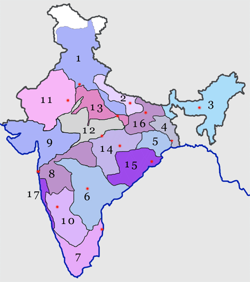
English: Zones sorted by their numbering 1-Northern 2-North Eastern 3-Northeast Frontier 4-Eastern 5-South Eastern 6-South Central 7-Southern 8-Central 9-Western 10-South Western 11-North Western 12-West Central 13-North Central 14-South East Central 15-East Coast 16-East Central 17-Konkan Railway |
|||||
| మూలం | Made by Nichalp | |||||
| కర్త | Nichalp | |||||
| ఇతర కూర్పులు |
|


Numbered map of the Indian Railways network: See w:Indian Railways
Map made by me, Nichalp

|
ఈ కృతి యొక్క కర్తనైన నేను, ఇక నుండీ ఈ కృతిని కాపీ చేసుకోవడానికి, పంచి పెట్టడానికి మరియు/లేదా మార్పులు-చేర్పులు చేసుకోవడానికి GFDL, లైసెన్సు వెర్షను 1.2 లేదా దాని తరువాత స్వేచ్చా సాఫ్టువేరు ఫౌండేషను విడుదలచేసే ఏ GFDL లైసెన్సు ద్వారా నయినా అనుమతి ఇస్తున్నాను; ఈ కృతిలో మార్చకూడని బాగాలు లేవు, Front-Cover పాఠం లేదు, Back-Cover పాఠం లేదు. ఈ లైసెన్సు యొక్క పత్రం నకలును "జిఎన్యూ ఉచిత డాక్యుమెంటేషను లైసెన్సు" అని పిలుస్తున్న విభాగంలో ఉంది.http://www.gnu.org/copyleft/fdl.htmlGFDLGNU Free Documentation Licensetruetrue |
| ఈ దస్త్రం క్రియేటివ్ కామన్స్ Attribution-Share Alike 3.0 Unported లైసెన్సు క్రింద లభ్యం. | ||
| ||
| GFDL లైసెన్సు తాజాకరణలో భాగంగా ఈ దస్త్రానికి ఈ లైసెన్సింగు ట్యాగుని చేర్చారు.http://creativecommons.org/licenses/by-sa/3.0/CC BY-SA 3.0Creative Commons Attribution-Share Alike 3.0truetrue |
Captions
Add a one-line explanation of what this file represents
Railway Zones In India
Items portrayed in this file
చిత్రణ
some value
copyright status ఇంగ్లీష్
copyrighted ఇంగ్లీష్
ఫైలు చరితం
తేదీ/సమయం ను నొక్కి ఆ సమయాన ఫైలు ఎలా ఉండేదో చూడవచ్చు.
| తేదీ/సమయం | నఖచిత్రం | కొలతలు | వాడుకరి | వ్యాఖ్య | |
|---|---|---|---|---|---|
| ప్రస్తుత | 14:39, 17 జూన్ 2005 | | 500 × 563 (33 KB) | Nichalp | Numbered map of the Indian Railways network: See w:Indian Railways ---- Map made by me, ~~~ ---- {{GFDL}} ---- category:Indian Railways category:Maps of India |
లింకులు
కింది పేజీలలో ఈ ఫైలుకు లింకులు ఉన్నాయి:
- ఆగ్నేయ మధ్య రైల్వే
- ఆగ్నేయ రైల్వే
- ఈశాన్య రైల్వే
- ఈశాన్య సరిహద్దు రైల్వే
- ఉత్తర మధ్య రైల్వే
- ఉత్తర రైల్వే
- తూర్పు తీర రైల్వే
- తూర్పు మధ్య రైల్వే
- తూర్పు రైల్వే
- దక్షిణ మధ్య రైల్వే
- దక్షిణ రైల్వే
- నైరుతి రైల్వే
- పశ్చిమ మధ్య రైల్వే
- పశ్చిమ రైల్వే
- భారతీయ రైలు రవాణా వ్యవస్థ
- భారతీయ రైల్వే జోన్లు
- మధ్య రైల్వే
- వాయవ్య రైల్వే
- సికిందరాబాద్ రైల్వే డివిజను
సార్వత్రిక ఫైలు వాడుక
ఈ దస్త్రాన్ని ఈ క్రింది ఇతర వికీలు ఉపయోగిస్తున్నాయి:
- as.wikipedia.org లో వాడుక
- bn.wikipedia.org లో వాడుక
- en.wikipedia.org లో వాడుక
- West Central Railway zone
- East Coast Railway zone
- South Central Railway zone
- Central Railway zone
- Western Railway zone
- North Western Railway zone
- Northeast Frontier Railway zone
- Southern Railway zone
- Eastern Railway zone
- Northern Railway zone
- South Western Railway zone
- North Central Railway zone
- South East Central Railway zone
- East Central Railway zone
- North Eastern Railway zone
- South Eastern Railway zone
- Indian Railways organisational structure
- Ajmer railway division
- Bikaner railway division
- Jodhpur railway division
- Jaipur railway division
- Rail transport in Haryana
- fa.wikipedia.org లో వాడుక
- hi.wikipedia.org లో వాడుక
- kn.wikipedia.org లో వాడుక
- mai.wikipedia.org లో వాడుక
- ml.wikipedia.org లో వాడుక
ఈ దస్త్రపు మరింత సార్వత్రిక వాడుకను చూడండి.
"https://te.wikipedia.org/wiki/దస్త్రం:Indianrailwayzones-numbered.png" నుండి వెలికితీశారు