File:Norwegian_Sea_map_sv.png
From Wikipedia, the free encyclopedia
ఈ మునుజూపు పరిమాణం: 657 × 600 పిక్సెళ్ళు. ఇతర రిజల్యూషన్లు: 263 × 240 పిక్సెళ్ళు | 526 × 480 పిక్సెళ్ళు | 1,000 × 913 పిక్సెళ్ళు.
అసలు దస్త్రం (1,000 × 913 పిక్సెళ్ళు, ఫైలు పరిమాణం: 360 KB, MIME రకం: image/png)
This is a file from the Wikimedia Commons. Information from its description page there is shown below. Commons is a freely licensed media file repository. You can help. |
| వివరణNorwegian Sea map sv.png |
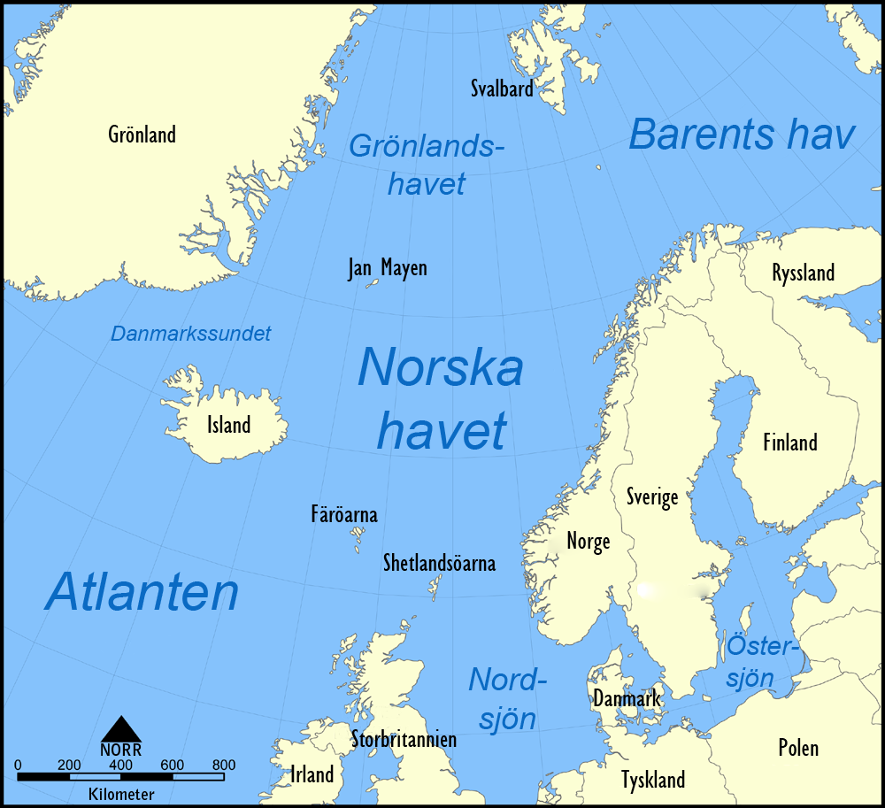
English: A map in Swedish showing the location of the Norwegian Sea in the North Atlantic Ocean.
Svenska: En svensk karta över Norska havets läge i norra Atlanten. |
| తేదీ | (UTC) |
| మూలం | |
| కర్త |
|
| ఇతర కూర్పులు |
[మార్చు]
|


నేను, ఈ కృతి యొక్క కాపీహక్కుదారుని, దీన్ని ఇందుమూలముగా ఈ లైసెన్సుల క్రింద ప్రచురిస్తున్నాను:
| ఈ దస్త్రం క్రియేటివ్ కామన్స్ Attribution-Share Alike 3.0 Unported లైసెన్సు క్రింద లభ్యం. | ||
| ||
| GFDL లైసెన్సు తాజాకరణలో భాగంగా ఈ దస్త్రానికి ఈ లైసెన్సింగు ట్యాగుని చేర్చారు.http://creativecommons.org/licenses/by-sa/3.0/CC BY-SA 3.0Creative Commons Attribution-Share Alike 3.0truetrue |

|
ఈ కృతి యొక్క కర్తనైన నేను, ఇక నుండీ ఈ కృతిని కాపీ చేసుకోవడానికి, పంచి పెట్టడానికి మరియు/లేదా మార్పులు-చేర్పులు చేసుకోవడానికి GFDL, లైసెన్సు వెర్షను 1.2 లేదా దాని తరువాత స్వేచ్చా సాఫ్టువేరు ఫౌండేషను విడుదలచేసే ఏ GFDL లైసెన్సు ద్వారా నయినా అనుమతి ఇస్తున్నాను; ఈ కృతిలో మార్చకూడని బాగాలు లేవు, Front-Cover పాఠం లేదు, Back-Cover పాఠం లేదు. ఈ లైసెన్సు యొక్క పత్రం నకలును "జిఎన్యూ ఉచిత డాక్యుమెంటేషను లైసెన్సు" అని పిలుస్తున్న విభాగంలో ఉంది.http://www.gnu.org/copyleft/fdl.htmlGFDLGNU Free Documentation Licensetruetrue |
పైవాటిలో మీకు నచ్చిన లైసెన్సునును ఎంచుకోవచ్చు.
అసలు ఎక్కింపుల చిట్టా
This image is a derivative work of the following images:
- File:Norwegian_Sea_map.png licensed with Cc-by-sa-3.0-migrated, GFDL
- 2005-11-07T16:10:45Z NormanEinstein 1000x913 (525159 Bytes)
| ఈ దస్త్రం క్రియేటివ్ కామన్స్ Attribution-Share Alike 3.0 Unported లైసెన్సు క్రింద లభ్యం. | ||
| ||
| GFDL లైసెన్సు తాజాకరణలో భాగంగా ఈ దస్త్రానికి ఈ లైసెన్సింగు ట్యాగుని చేర్చారు.http://creativecommons.org/licenses/by-sa/3.0/CC BY-SA 3.0Creative Commons Attribution-Share Alike 3.0truetrue |
Captions
Add a one-line explanation of what this file represents
Items portrayed in this file
చిత్రణ
copyright status ఇంగ్లీష్
copyrighted ఇంగ్లీష్
25 ఆగస్టు 2010
ఫైలు చరితం
తేదీ/సమయం ను నొక్కి ఆ సమయాన ఫైలు ఎలా ఉండేదో చూడవచ్చు.
| తేదీ/సమయం | నఖచిత్రం | కొలతలు | వాడుకరి | వ్యాఖ్య | |
|---|---|---|---|---|---|
| ప్రస్తుత | 09:35, 25 ఆగస్టు 2010 | | 1,000 × 913 (360 KB) | Dcastor | {{Information |Description={{en|A map in Swedish showing the location of the Norwegian Sea in the North Atlantic Ocean.}} {{sv|En svensk karta över Norska havets läge i norra Atlanten.}} |Source=*File:Norwegian_Sea_map.png |Date=2010-08-25 09:25 ( |
లింకులు
ఈ ఫైలును వాడుతున్న పేజీలు లేవు.
సార్వత్రిక ఫైలు వాడుక
ఈ దస్త్రాన్ని ఈ క్రింది ఇతర వికీలు ఉపయోగిస్తున్నాయి:
- sv.wikipedia.org లో వాడుక
"https://te.wikipedia.org/wiki/దస్త్రం:Norwegian_Sea_map_sv.png" నుండి వెలికితీశారు