File:United_States_1848-02-1848-05.png
From Wikipedia, the free encyclopedia
Storlek på förhandsvisningen: 800 × 542 pixlar. Andra upplösningar: 320 × 217 pixlar | 640 × 433 pixlar | 1 000 × 677 pixlar.
Originalfil (1 000 × 677 pixlar, filstorlek: 90 kbyte, MIME-typ: image/png)
| Denna fil tillhandahålls av Wikimedia Commons. Informationen nedan är kopierad från dess filbeskrivningssida. |
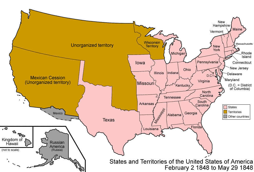
| BeskrivningUnited States 1848-02-1848-05.png | Map of the states and territories of the United States as it was from February 1848 to May 1848. On February 2 1848, as a result of the Mexican-American War, Mexico ceded a large portion of its land to the United States. On May 29 1848, most of Wisconsin Territory was admitted as the state of Wisconsin, and the remainer became unorganized. |
| Källa | Eget arbete |
| Skapare | Made by User:Golbez. |
| Tillstånd (Återanvändning av denna fil) |
Own work, attribution required (Multi-license with GFDL and Creative Commons CC-BY 2.5) |
Jag, upphovsrättsinnehavaren av detta verk, publicerar härmed det under följande licenser:

|
Tillstånd ges att kopiera, distribuera och/eller modifiera detta dokument under villkoren i GNU Free Documentation License, Version 1.2 eller senare version publicerad av Free Software Foundation, utan oföränderliga avsnitt, framsidestexter eller baksidestexter. En kopia av licensen ingår i avsnittet GNU Free Documentation License.http://www.gnu.org/copyleft/fdl.htmlGFDLGNU Free Documentation Licensetruetrue |
| Denna fil har gjorts tillgänglig under licensen Creative Commons Erkännande-Dela Lika 3.0 Unported | ||
| ||
| Detta licenstillägg lades till till denna fil som en del av GFDL:s licensuppdatering.http://creativecommons.org/licenses/by-sa/3.0/CC BY-SA 3.0Creative Commons Attribution-Share Alike 3.0truetrue |
Denna fil har gjorts tillgänglig under licensen Creative Commons Erkännande 2.5 Generisk
- Du är fri:
- att dela – att kopiera, distribuera och sända verket
- att remixa – att skapa bearbetningar
- På följande villkor:
- erkännande – Du måste ge lämpligt erkännande, ange en länk till licensen och indikera om ändringar har gjorts. Du får göra det på ett lämpligt sätt, men inte på ett sätt som antyder att licensgivaren stödjer dig eller din användning.
Du får själv välja den licens du vill använda.
| Territorial evolution maps of the United States |
| v · d (template shows date of beginning of change yyyy-mm-dd) |
| 1789-03, 1789-08, 1790-04, 1790-05, 1791-03, 1791-09, 1792-03, 1792-06, 1795, 1796, 1798, 1800-07-04, 1800-07, 1802, 1803-03, 1803-04, 1804-03, 1804-10, 1805-01, 1805-07, 1809, 1810-04, 1810-10, 1812-04, 1812-05, 1812-06, 1816, 1817-03, 1817-12, 1818-10, 1818-12, 1819-03, 1819-12, 1820, 1821-07, 1821, 1822, 1824, 1828, 1834, 1836-03, 1836-06, 1836-07, 1837-01, 1837-03, 1838, 1842, 1845-03, 1845-12, 1846-06, 1846-12, 1848-02, 1848-05, 1848-08, 1849, 1850, 1853-03, 1853-12, 1854, 1858, 1859, 1860, 1861-01, 1861-02-04, 1861-02-28, 1861-03, 1861-08, 1862, 1863-02, 1863-03, 1863-06, 1864-05, 1864-10, 1865, 1866, 1867-01, 1867-03, 1867-10, 1868, 1876, 1884, 1889-11-02, 1889-11-08, 1889-11-11, 1890-05, 1890-07-03, 1890-07-10, 1896-01, 1896-05, 1898, 1907, 1912-01, 1912-02, 1912-08, 1959-01, 1959-08 |
Bildtexter
Ingen bildtext har definierats
Objekt som porträtteras i den här filen
motiv
Filhistorik
Klicka på ett datum/klockslag för att se filen som den såg ut då.
| Datum/Tid | Miniatyrbild | Dimensioner | Användare | Kommentar | |
|---|---|---|---|---|---|
| nuvarande | 29 juli 2006 kl. 09.04 | | 1 000 × 677 (90 kbyte) | Golbez | {{Information| |Description=Map of the states and territories of the United States as it was from |Source= |Date= |Author=Made by User:Golbez. |Permission=Own work, attribution required (Multi-license with GFDL and Creative Commons CC-BY 2.5) |other_ |
Filanvändning
Inga sidor använder den här filen.
Global filanvändning
Följande andra wikier använder denna fil:
- Användande på de.wikipedia.org
- Användande på en.wikipedia.org
- User:Buaidh/Territorial evolution of Colorado
- List of territorial claims and designations in Colorado
- Territorial evolution of New Mexico
- Outline of Wyoming territorial evolution
- Territorial evolution of Utah
- Territorial evolution of Arizona
- Territorial evolution of Nevada
- Territorial evolution of California
- User:Falcaorib/Canada, United States and Mexico
- Användande på es.wikipedia.org
- Användande på fr.wikipedia.org
- Användande på ja.wikipedia.org
- Användande på lb.wikipedia.org
- Användande på vi.wikipedia.org
- Användande på zh.wikipedia.org