File:East-Hem_700ad.jpg
From Wikipedia, the free encyclopedia
Оригинална датотека (3.240 × 1.903 пиксела, величина датотеке: 924 kB, MIME тип: image/jpeg)
| Ово је датотека са Викимедијине оставе. Информације са њене странице са описом приказане су испод. Викимедијина остава је складиште слободно лиценциралних мултимедијалних датотека. И Ви можете да помогнете. |

|
Ова historical map слика требало би да буду поново израђене као векторска графика у SVG формату. Тиме се остварује неколико предности. Више информација потражите на Commons:Media for cleanup. Ако је ова слика већ доступна у SVG формату, отпремите је. Након отпремања датотеке, овај шаблон замените шаблоном {{vector version available|new image name.svg}}.
|
 | This historical map image was uploaded in the JPEG format even though it consists of non-photographic data. This information could be stored more efficiently or accurately in the PNG or SVG format. If possible, please upload a PNG or SVG version of this image without compression artifacts, derived from a non-JPEG source (or with existing artifacts removed). After doing so, please tag the JPEG version with {{Superseded|NewImage.ext}} and remove this tag. This tag should not be applied to photographs or scans. If this image is a diagram or other image suitable for vectorisation, please tag this image with {{Convert to SVG}} instead of {{BadJPEG}}. If not suitable for vectorisation, use {{Convert to PNG}}. For more information, see {{BadJPEG}}. |  |
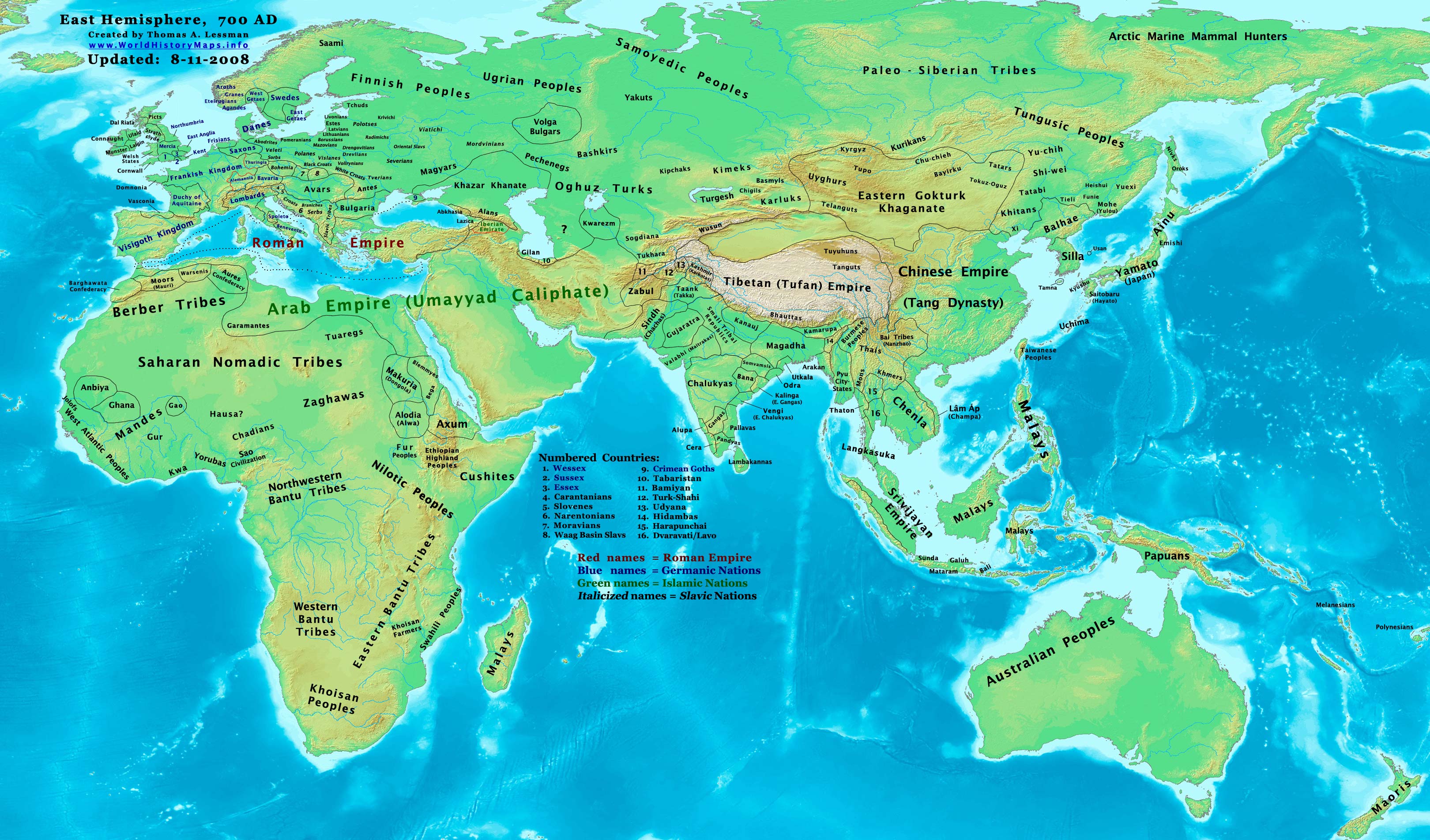
| ОписEast-Hem 700ad.jpg | Eastern Hemisphere in 700 AD. |
| Извор | self-made (For reference information, see the Map Source References section below.) |
| Аутор | Thomas Lessman (Contact!) |
| Дозвола (Поновно коришћење ове датотеке) |
Ја, носилац ауторског права над овим делом, објављујем исто под следећом лиценцом: Ова датотека је доступна под лиценцом Creative Commons Ауторство-Делити под истим условима 3.0 Unported.
|
| Остале верзије |
Derivative works of this file: Part of East-Hem 700ad.jpg see East-Hem_700ad.jpg file history on Wikipedia. |
Map Summary
Original Source URL: http://www.thomaslessman.com/History/images/East-Hem_700ad.jpg.
This map of the Eastern Hemisphere in 700 AD was created by Thomas Lessman, based on information from the sources listed below. This map is free for educational use (see Permission info above). When using this map, please mention that it is available for free at www.WorldHistoryMaps.info.
Map Source References
- Remember, sources often conflict with each other. This map is only as accurate as the information that is available to me. To report any errors or to help further this work, please click here, or email Thomas Lessman at talessman@yis.us
References for information contained in this map:
1. Borders of Europe are mostly derived from the www.Euratlas.com map of Europe in 700 AD archive copy at the Wayback Machine.
- (Please note: User:Bogomolov.PL has done a great job of showing me possible discrepancies in my north European borders compared to this source, due to the differences in the geographical layout of the maps.)
2. Asian information is mostly derived from the following sources:
- 2a. Wikimedia's World Map 700 CE, created by User:Javierfv1212.
- 2b. Map of Asia in 750 AD, from Huhai.net.
- Please note: borders between Tibet and India are in question due to conflicts between source information:
- 2c. My depiction of Tibet's borders with India are based on these sources:
- 1: DK Atlas of World History (2000 edition, pg. 262), showing Tibet's borders in 800 AD, with northern India (the entire length of the Ganges, almost to the Indus river) under Tibet's control.
- 2: Huhai.net's map of Asia in 750 AD, which shows Tibetan control over Kamarupa, Bengal, and Pala.
- 3: "Himalayan Region, 500–1000 A.D." in Timeline of Art History. New York: The Metropolitan Museum of Art, (October 2001)
- 4: Google Book's "History of Tibet" (Page 54), makes several notes of Nepal's Licchavi dynasty as vassals of Tibet, and also says that India's Pala Empire under King Dharmapala accepted Tibetan overlordship.
- 5: Google Book's "Ancient India", (Page 632), describes Tibetan activities during the reigns of Songtsan Gampo and King Harsha of Kannauj. Also describes the Tibetan subjucation of Kamarupa and Kannauj after the death of King Harsha.
- 6: Wikipedia's article about Tibetan King Songtsän Gampo states that Tibet and Nepal invaded India in 648 AD and defeated Harsha's successor, after the Indian King had attacked a Chinese envoy named Wang Xuanze. (That statement referenced with Stein, R. A. Tibetan Civilization 1962. Revised English edition, 1972, Faber & Faber, London. Reprint, 1972. Stanford University Press, p. 62. ISBN 0-8047-0806-1 cloth; ISBN 0-8047-0901-7 pbk., pp. 58-59)
- Possible alternative borders for Indias Kamarupa, Gauda, Tripura, and Manipur can be seen on User:Porikolpok_Oxom map of Kamarupa 7th-8th Century AD.
3. Fringe areas like Africa, Australia, Siberia, etc. derive from Wikimedia's map of the World Map 700 CE, created by User:Javierfv1212.
4. Much of the information in this map was cross-checked with Bruce Gordon's Regnal Chronologies.
Other Maps by Thomas Lessman
| Maps of the eastern hemisphere showing history
Bold dates are available on Wikimedia or Wikipedia. | ||
| Primeval | ||
| Ancient
|
·| 600 BC | 550 BC | 527 BC | 500 BC |
400 BC | ·| 1 AD | 50 AD | 100 AD | 200 AD | 300 AD | | |
| Medieval |
·| 500 AD | 565 AD | 600 AD | 700 AD | | |
| Modern |
·| 1500 AD | · * For historical maps of the whole world, | |
| history links talk edit view | ||
Натписи
Ставке приказане у овој датотеци
приказује
Нека вредност без ставке на Википодаци
image/jpeg
Историја датотеке
Кликните на датум/време да бисте видели тадашњу верзију датотеке.
| Датум/време | Минијатура | Димензије | Корисник | Коментар | |
|---|---|---|---|---|---|
| тренутна | 19:42, 13. октобар 2022. | | 3.240 × 1.903 (924 kB) | Gyalu22 | Reverted to version as of 20:11, 11 August 2008 (UTC) This is not an ethnic map. |
| 15:37, 6. мај 2016. |  | 3.240 × 1.903 (2,33 MB) | Julieta39 | Cosmetic changes according with « Putzger historischer Weltatlas Cornelsen » 1990 - ISBN 3-464-00176-8 ; « Atlas historique Georges Duby » Larousse 1987 - ISBN 2-03-503009-9 ; André & Jean Sellier's « Atlas des Peuples » La Découverte : issues... | |
| 22:11, 11. август 2008. |  | 3.240 × 1.903 (924 kB) | Talessman | {{Information |Description= |Source= |Date= |Author= |Permission= |other_versions= }} | |
| 20:37, 9. мај 2008. |  | 3.240 × 1.903 (737 kB) | Talessman | {{Information |Description=Eastern Hemisphere in 700 AD. |Source=self-made |Author=Thomas Lessman |Permission={{self|cc-by-sa-3.0}} }} |
Употреба датотеке
Нема страница које користе ову датотеку.
Глобална употреба датотеке
Други викији који користе ову датотеку:
- Употреба на ar.wikipedia.org
- Употреба на arz.wikipedia.org
- Употреба на azb.wikipedia.org
- Употреба на bar.wikipedia.org
- Употреба на be.wikipedia.org
- Употреба на bs.wikipedia.org
- Употреба на ca.wikipedia.org
- Употреба на cs.wikipedia.org
- Употреба на da.wikipedia.org
- Употреба на de.wikipedia.org
- Употреба на en.wikipedia.org
- 7th century
- 8th century
- 745
- 700
- History of the Khitans
- User:Tompw/sandbox10
- File:Tibet 700ad.jpg
- User:Talessman/Maps
- User talk:Talessman/Maps
- Tibetan Empire
- History of the Great Wall of China
- User:Benjamin Trovato/sandbox
- List of states during the Middle Ages
- List of political entities in the 7th century
- User:Navops47/sandbox10
- Wikipedia:Graphics Lab/Map workshop/Archive/Feb 2018
- User:Falcaorib/Ancient East Hemisphere
- Употреба на es.wikipedia.org
- Употреба на et.wikipedia.org
- Употреба на fa.wikipedia.org
- Употреба на frr.wikipedia.org
- Употреба на fr.wikipedia.org
- Употреба на gl.wikipedia.org
- Употреба на hi.wikipedia.org
- Употреба на hu.wikipedia.org
- Употреба на hy.wikipedia.org
- Употреба на id.wikipedia.org
- Употреба на it.wikipedia.org
Још глобалног коришћења ове датотеке.